Grant, Michigan
| Grant, Michigan | |
|---|---|
| City | |
 Location of Grant within Newaygo County, Michigan | |
| Coordinates: 43°20′10.00″N 85°48′39.00″W / 43.3361111°N 85.8108333°WCoordinates: 43°20′10.00″N 85°48′39.00″W / 43.3361111°N 85.8108333°W | |
| Country | United States |
| State | Michigan |
| County | Newaygo |
| Government | |
| • Mayor | Terry A. Fett |
| Area[1] | |
| • Total | 0.67 sq mi (1.74 km2) |
| • Land | 0.65 sq mi (1.68 km2) |
| • Water | 0.02 sq mi (0.05 km2) |
| Elevation | 833 ft (255 m) |
| Population (2010)[2] | |
| • Total | 894 |
| • Estimate (2012[3]) | 885 |
| • Density | 1,375.4/sq mi (531.0/km2) |
| Time zone | EST (UTC-5) |
| • Summer (DST) | EDT (UTC-4) |
| ZIP code | 49327 |
| Area code(s) | 231 |
| FIPS code | 26-34360[4] |
| GNIS feature ID | 0627144[5] |
| Website |
www |
Grant is a city in Newaygo County in the U.S. state of Michigan. The population was 894 at the 2010 census. The city is on the boundary between Grant Township and Ashland Township, but is politically independent of both. It is a part of the Grand Rapids-Muskegon-Holland, Michigan combined statistical area, and is an exurb of Grand Rapids, due to its major commuter route into Grand Rapids along M-37 and into Muskegon along M-46, both cities being about 30 minutes away.
Geography
According to the United States Census Bureau, the city has a total area of 0.67 square miles (1.74 km2), of which 0.65 square miles (1.68 km2) is land and 0.02 square miles (0.05 km2) is water.[1]
Demographics
| Historical population | |||
|---|---|---|---|
| Census | Pop. | %± | |
| 1880 | 90 | — | |
| 1900 | 214 | — | |
| 1910 | 428 | 100.0% | |
| 1920 | 473 | 10.5% | |
| 1930 | 483 | 2.1% | |
| 1940 | 552 | 14.3% | |
| 1950 | 646 | 17.0% | |
| 1960 | 732 | 13.3% | |
| 1970 | 772 | 5.5% | |
| 1980 | 683 | −11.5% | |
| 1990 | 764 | 11.9% | |
| 2000 | 881 | 15.3% | |
| 2010 | 894 | 1.5% | |
| Est. 2015 | 882 | [6] | −1.3% |
2010 census
As of the census[2] of 2010, there were 894 people, 361 households, and 229 families residing in the city. The population density was 1,375.4 inhabitants per square mile (531.0/km2). There were 416 housing units at an average density of 640.0 per square mile (247.1/km2). The racial makeup of the city was 93.8% White, 0.1% African American, 0.4% Native American, 0.3% Asian, 4.5% from other races, and 0.8% from two or more races. Hispanic or Latino of any race were 13.3% of the population.
There were 361 households, of which 37.7% had children under the age of 18 living with them, 41.0% were married couples living together, 17.2% had a female householder with no husband present, 5.3% had a male householder with no wife present, and 36.6% were non-families. 31.9% of all households were made up of individuals and 18.5% had someone living alone who was 65 years of age or older. The average household size was 2.46, and the average family size was 3.06.
The median age in the city was 31.9 years. 29.5% of residents were under the age of 18; 9.2% were between the ages of 18 and 24; 24.8% were from 25 to 44; 20.9% were from 45 to 64; and 15.7% were 65 years of age or older. The gender makeup of the city was 46.2% male and 53.8% female.
2000 census
As of the census[4] of 2000, there were 881 people, 323 households, and 214 families residing in the city. The population density was 1,350.1 per square mile (523.3/km²). There were 344 housing units at an average density of 527.2 per square mile (204.3/km²). The racial makeup of the city was 95.12% White, 0.23% African American, 0.23% Native American, 0.11% Asian, 2.04% from other races, and 2.27% from two or more races. Hispanic or Latino of any race were 10.33% of the population.
There were 323 households, out of which 37.5% had children under the age of 18 living with them, 48.0% were married couples living together, 14.6% had a female householder with no husband present, and 33.7% were non-families. 29.1% of all households were made up of individuals and 19.2% had someone living alone who was 65 years of age or older. The average household size was 2.59, and the average family size was 3.22.
In the city the population was spread out, with 29.6% under the age of 18, 11.2% from 18 to 24, 24.6% from 25 to 44, 16.2% from 45 to 64, and 18.3% who were 65 years of age or older. The median age was 32 years. For every 100 females there were 86.3 males. For every 100 females age 18 and over, there were 76.1 males.
The median income for a household in the city was $50,972, and the median income for a family was $44,583. Males had a median income of $41,250 versus $26,696 for females. The per capita income for the city was $15,308. About 11.1% of families and 20.8% of the population were below the poverty line, including 26.1% of those under age 18 and 19.9% of those age 65 or over.
Community Information
The City of Grant is located in Newaygo County at the junction of 120th and M-37. Grant is 25 miles (40 km) north of Grand Rapids, 25 miles (40 km) north-east of Muskegon (the two principal cities in West Michigan), and 160 miles (260 km) northeast of Chicago. The community of Grant is known for the Fine Arts. The Grant Fine Arts Center seats about 800 people, and holds many events throughout the year. Grant is also known for its prominent agricultural industry, In 1915, 10 to 12 cars of peaches were shipped from Grant per day, and in the 1930s countless carloads of onions were also being shipped from Grant, for a while earning it the title of “Onion Capital of the World.” Since then area growers now plant a variety of different crops, and no longer ship record amounts of onions, however having some of the largest muck farms east of the Mississippi River, produce grown in Grant still finds its way to grocery stores across North America.
Education
The Grant Public School District operates four main school buildings all located relatively close to each other: two Elementary schools (K-4), one Middle school (5-8), and one High school (9-12). The district also operates the Grant Learning Center which houses the Alternative High School, as well as the Building Bridges Preschool. In September 2002, the community voted in favor of a bonding proposal for 26 years, to construct a $7.4 million state-of-the-art Fine Arts Center. Student enrollment of over 2,400 is the second largest in Newaygo County, and the graduation rate of 97.03% is the highest in the County.
The Grant Christian School is located 4 miles (6 km) east of the city in Grant Township at 12931 Poplar Avenue. It is a multi-denominational, private and parent controlled institution governed by a Board of Trustees which are elected from the supporting school society. The school has been in operation since 1946, it educates approximately 100 students in grades PK-8, and is a member of Christian Schools International.
The Grant Area District Library (GADL) is located at 122 South Elder, near the Middle School. The library serves a population of about 8,500 people with a collection of about 30,000 items. Annually the library circulates over 57,000 items.[8] It is a member of the Lakeland Library Cooperative and participates in Cooperative's Interlibrary Loan Program. Which allows GADL patrons access to almost 4 million items from 84 other member libraries.
History
The history of Grant Center started in 1882 when Andrew J. Squier built the first saw mill. In the same year a railroad station was built on the Pere Marquette Railroad in Grant Center. Grant Center was incorporated in 1893, and the name was shortened to Grant in 1899. The City of Grant is named after President and Civil War General Ulysses S. Grant. During the community's early years, 20,000 board feet (47 m3) of lumber and 30,000 shingles per day were shipped out of Grant. In 1885 Squire was producing 1 million board feet (2,360 m3) of lumber per year, and in 1872 and 1873 9 million board feet (21,200 m3) of logs were shipped to Grand Rapids from Newaygo County, most of it coming from the Ashland Station two miles (3 km) south of present-day Grant, at the rate of 100,000 a day.
During World War II a German Prisoner of War camp was located 2.5 miles east of town, on the south-east corner of 120th St. and Walnut Ave.
Notable people from Grant
- William Herman Bolthouse, early founder of Wm. Bolthouse Farms, a national leading producer of carrots and super premium refrigerated products.
- Kristian Ostergaard - Danish-American Lutheran Minister and founder of the Ashland Folk School (1882–1938).[9]
Historical Sites
Major highways
References
- 1 2 "US Gazetteer files 2010". United States Census Bureau. Retrieved 2012-11-25.
- 1 2 "American FactFinder". United States Census Bureau. Retrieved 2012-11-25.
- ↑ "Population Estimates". United States Census Bureau. Retrieved 2013-06-03.
- 1 2 "American FactFinder". United States Census Bureau. Retrieved 2008-01-31.
- ↑ "US Board on Geographic Names". United States Geological Survey. 2007-10-25. Retrieved 2008-01-31.
- ↑ "Annual Estimates of the Resident Population for Incorporated Places: April 1, 2010 to July 1, 2015". Retrieved July 2, 2016.
- ↑ "Census of Population and Housing". Census.gov. Retrieved June 4, 2015.
- ↑ "National Center for Education Statistics". Retrieved 2009-05-30.
- ↑ Kristian Ostergaard, 1855-1931 (The Cyber Hymnal)
External links
- City of Grant
- Integrated Chamber for Croton-Hardy, Grant, Newaygo & White Cloud
- Grant Fine Arts Center
- Grant Public Schools
- Grant Public Schools Music Department
- All about the Danish College
Municipalities and communities of Newaygo County, Michigan, United States | ||
|---|---|---|
| Cities | 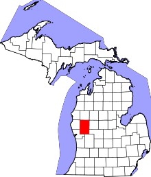 | |
| Village | ||
| Charter township | ||
| General law townships | ||
| Unincorporated communities | ||
| Footnotes | ‡This populated place also has portions in an adjacent county or counties | |