Grant Glacier
| Grant Glacier | |
|---|---|
|
Grant Glacier as seen in 1998 | |
 Grant Glacier Location in Montana | |
| Type | Cirque glacier |
| Location | Flathead County, Montana, U.S. |
| Coordinates | 48°19′24″N 113°45′06″W / 48.32333°N 113.75167°WCoordinates: 48°19′24″N 113°45′06″W / 48.32333°N 113.75167°W[1] |
| Area | 83 acres (34 ha) (in 1995) |
| Length | .25 mi (0.40 km) |
| Terminus | Barren rock |
| Status | Retreating |
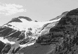
Grant Glacier is located in the US state of Montana in Flathead National Forest. The glacier is situated in a cirque and lies below the east slopes of Mount Grant (8,590 feet (2,620 m)).[2] Grant Glacier is 1 mile (1.6 km) southeast of Stanton Glacier and both 5 miles (8.0 km) west of Glacier National Park (U.S.). Images taken of the glacier in 1902 and from the same vantage point in 1998 indicate that the glacier retreated substantially during the 20th Century.[3]
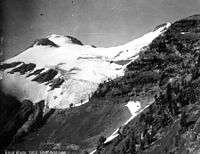
Comparing the image at right taken in 1998, with this image taken in 1902, substantial retreat of Grant Glacier over the course of the 20th Century is apparent
See also
References
- ↑ "Grant Glacier". Geographic Names Information System. United States Geological Survey. Retrieved 2012-09-01.
- ↑ Mount Grant, MT (Map). TopoQwest (United States Geological Survey Maps). Retrieved 2012-09-01.
- ↑ "Grant Glacier from Grant Ridge, Flathead National Forest, Montana". USGS Repeat Photography Project Documents Retreating Glaciers in Glacier National Park. United States Geological Survey. August 2011. Retrieved 2012-09-01.
This article is issued from Wikipedia - version of the 12/24/2015. The text is available under the Creative Commons Attribution/Share Alike but additional terms may apply for the media files.