Grantola
| Grantola | |
|---|---|
| Comune | |
| Comune di Grantola | |
 Grantola Location of Grantola in Italy | |
| Coordinates: 45°57′N 8°47′E / 45.950°N 8.783°ECoordinates: 45°57′N 8°47′E / 45.950°N 8.783°E | |
| Country | Italy |
| Region | Lombardy |
| Province / Metropolitan city | Province of Varese (VA) |
| Frazioni | Bellaria, Motta, Montebello, Vicema |
| Area | |
| • Total | 2.1 km2 (0.8 sq mi) |
| Elevation | 250 m (820 ft) |
| Population (Feb. 2007) | |
| • Total | 1,251 |
| • Density | 600/km2 (1,500/sq mi) |
| Demonym(s) | Grantolesi |
| Time zone | CET (UTC+1) |
| • Summer (DST) | CEST (UTC+2) |
| Postal code | 21030 |
| Dialing code | 0332 |
Grantola is a comune (municipality) in the Province of Varese in the Italian region Lombardy, located about 60 kilometres (37 mi) northwest of Milan and about 15 kilometres (9 mi) north of Varese. As of 28 February 2007, it had a population of 1,251 and an area of 2.1 square kilometres (0.81 sq mi).[1]
The municipality of Grantola contains the frazioni (subdivisions, mainly villages and hamlets) Bellaria, Motta, Montebello, and Vicema.
Grantola borders the following municipalities: Cassano Valcuvia, Cugliate-Fabiasco, Cunardo, Ferrera di Varese, Mesenzana, Montegrino Valtravaglia.
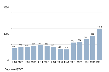
Demographic evolution
References
This article is issued from Wikipedia - version of the 1/31/2015. The text is available under the Creative Commons Attribution/Share Alike but additional terms may apply for the media files.