Graymoor-Devondale, Kentucky
| Graymoor-Devondale, Kentucky | |
|---|---|
| City | |
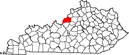
 Graymoor-Devondale, Kentucky Location within the state of Kentucky | |
| Coordinates: 38°16′24″N 85°37′2″W / 38.27333°N 85.61722°WCoordinates: 38°16′24″N 85°37′2″W / 38.27333°N 85.61722°W | |
| Country | United States |
| State | Kentucky |
| County | Jefferson |
| Named for | two predecessor cities |
| Area | |
| • Total | 0.7 sq mi (1.9 km2) |
| • Land | 0.7 sq mi (1.9 km2) |
| • Water | 0.0 sq mi (0.0 km2) |
| Elevation | 587 ft (179 m) |
| Population (2000) | |
| • Total | 2,925 |
| • Density | 4,002.9/sq mi (1,545.5/km2) |
| Time zone | Eastern (EST) (UTC-5) |
| • Summer (DST) | EDT (UTC-4) |
| FIPS code | 21-32523 |
| GNIS feature ID | 0493206 |
Graymoor-Devondale is a home rule-class city[1] in Jefferson County, Kentucky, United States. The city is the result of the merger of the former cities of Graymoor and Devondale. The population was 2,925 at the 2000 census.
Geography
Graymoor-Devondale is located at 38°16′24″N 85°37′2″W / 38.27333°N 85.61722°W (38.273370, -85.617259).[2]
According to the United States Census Bureau, the city has a total area of 0.7 square miles (1.8 km2), all land.
History
Devondale was incorporated sometime in 1958[3] and apparently named for a local farm.[4]
Graymoor was also named for a local farm, itself named for the monastery of the Society of the Atonement in Garrison, New York.[5] Merged with the nearby subdivision of Woodstock,[6] it was formally incorporated by the state assembly on November 17, 1959.[6]
Graymoor and Devondale merged on November 6, 1985,[6] and were reïncorporated together on November 23, 1987.[7] This allowed them (in 1992) to reach 4th-class status and control the zoning of properties around the Westport Rd.–Herr Ln. intersection.[8]
Demographics
| Historical population | |||
|---|---|---|---|
| Census | Pop. | %± | |
| 1990 | 2,911 | — | |
| 2000 | 2,925 | 0.5% | |
| 2010 | 2,870 | −1.9% | |
| Est. 2015 | 2,950 | [9] | 2.8% |
As of the 2000 U.S. census,[11] there were 2,925 people, 1,134 households, and 742 families residing in the city. The population density was 4,002.9 people per square mile (1,547.1/km²). There were 1,157 housing units at an average density of 1,583.4 per square mile (611.9/km²). The racial makeup of the city was 90.39% White, 5.20% Black or African American, 0.31% Native American, 2.43% Asian, 0.17% Pacific Islander, 0.58% from other races, and 0.92% from two or more races. Hispanic or Latino of any race were 1.71% of the population.
There were 1,134 households out of which 27.6% had children under the age of 18 living with them, 53.3% were married couples living together, 9.7% had a female householder with no husband present, and 34.5% were non-families. 31.2% of all households were made up of individuals and 14.0% had someone living alone who was 65 years of age or older. The average household size was 2.28 and the average family size was 2.86.
In the city the population was spread out with 19.8% under the age of 18, 5.3% from 18 to 24, 23.0% from 25 to 44, 21.6% from 45 to 64, and 30.4% who were 65 years of age or older. The median age was 46 years. For every 100 females there were 75.0 males. For every 100 females age 18 and over, there were 67.2 males.
The median income for a household in the city was $51,065, and the median income for a family was $66,613. Males had a median income of $46,283 versus $30,431 for females. The per capita income for the city was $29,755. About 2.4% of families and 3.0% of the population were below the poverty line, including 2.4% of those under age 18 and 0.6% of those age 65 or over.
References
- ↑ "Summary and Reference Guide to House Bill 331 City Classification Reform" (PDF). Kentucky League of Cities. Retrieved December 30, 2014.
- ↑ "US Gazetteer files: 2010, 2000, and 1990". United States Census Bureau. 2011-02-12. Retrieved 2011-04-23.
- ↑ Commonwealth of Kentucky. Office of the Secretary of State. Land Office. "Devondale, Kentucky". Accessed 28 Jul 2013.
- ↑ Vollenweider, B.A.H. Memories revisited: the Life and Family of W.W. "Bill" Henley, (1905–1982) and Reba Elizabeth Miars Henley (1905–1994): Their Lives, Descendants, and Ancestors. Gateway Press, 1995. Accessed 29 Jul 2013.
- ↑ Rennick, Robert M. (1987). Kentucky Place Names. University Press of Kentucky. p. 123. Retrieved 28 Apr 2013.
- 1 2 3 Commonwealth of Kentucky. Office of the Secretary of State. Land Office. "Graymoor, Kentucky". Accessed 28 Jul 2013.
- ↑ Commonwealth of Kentucky. Office of the Secretary of State. Land Office. "Graymoor-Devondale, Kentucky". Accessed 28 Jul 2013.
- ↑ The Encyclopedia of Louisville, p. 353. "Graymoor-Devondale". University Press of Kentucky (Lexington), 2001. ISBN 0813128900, 9780813128900. Accessed 29 Jul 2013.
- ↑ "Annual Estimates of the Resident Population for Incorporated Places: April 1, 2010 to July 1, 2015". Retrieved July 2, 2016.
- ↑ "Census of Population and Housing". Census.gov. Retrieved June 4, 2015.
- ↑ "American FactFinder". United States Census Bureau. Retrieved 2008-01-31.
| History |
|  |
|---|---|---|
| Geography |
| |
| Government |
| |
| Transportation | ||
| Other subject areas | ||
| Top subjects | ||
| National Historic Landmarks | ||
| Prominent suburbs (over 10K pop.) | ||
| ||