Hünfelden
| Hünfelden | ||
|---|---|---|
| ||
 Hünfelden | ||
Location of Hünfelden within Limburg-Weilburg district 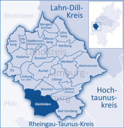 | ||
| Coordinates: 50°20′N 8°9′E / 50.333°N 8.150°ECoordinates: 50°20′N 8°9′E / 50.333°N 8.150°E | ||
| Country | Germany | |
| State | Hesse | |
| Admin. region | Gießen | |
| District | Limburg-Weilburg | |
| Government | ||
| • Mayor | Silvia Scheu -Menzer (Ind.) | |
| Area | ||
| • Total | 62.7 km2 (24.2 sq mi) | |
| Population (2015-12-31)[1] | ||
| • Total | 9,646 | |
| • Density | 150/km2 (400/sq mi) | |
| Time zone | CET/CEST (UTC+1/+2) | |
| Postal codes | 65597 | |
| Dialling codes | 06438 06431 Mensfelden | |
| Vehicle registration | LM | |
| Website | www.huenfelden.de | |

Hünfelden is a community in Limburg-Weilburg district in Hesse, Germany. Hünfelden lies on the Hühnerstraße, an historic part of Bundesstraße 417.
Geography
Location
Hünfelden lies in the Taunus north of Wiesbaden, 9 km southeast of Limburg an der Lahn.
Neighbouring communities
Hünfelden borders in the north on the town of Limburg and the community of Brechen, in the east on the community of Selters and the town of Bad Camberg (all in Limburg-Weilburg), in the south on the communities of Hünstetten and Aarbergen (both in Rheingau-Taunus-Kreis), and in the west on the Verbandsgemeinden (a kind of collective municipality) of Hahnstätten and Diez (both in Rhein-Lahn-Kreis in Rhineland-Palatinate).
Constituent communities
The community consists of seven Ortsteile, each formerly autonomous, listed here with population figures as at 1 January 2008.
- Kirberg: 2394
- Dauborn: 2764
- Mensfelden: 1339
- Heringen: 1055
- Nauheim: 997
- Ohren: 811
- Neesbach: 805
History
The community of Hünfelden came into being within the framework of administrative reform in Hesse on 1 October 1971 through the voluntary merger of the then autonomous communities of Dauborn, Heringen, Kirberg, Mensfelden, Nauheim, Neesbach and Ohren. The name “Hünfelden” was chosen then because of the great number of cromlechs – Hünengräber in German – from Hallstatt times around the centres of Heringen and Ohren. At the time of founding, the community’s population was 6,952.
Among Hünfelden’s constituent communities, Mensfelden can claim the earliest documentary mention, which came in 775. Dauborn, Heringen and the now long-vanished village of Bubenheim, which lay in the area of today’s Kirberg, followed in 790 in the Prüm Abbey’s golden book. Through Hünfelden’s current municipal area ran the Via Publica as well as the Hühnerstraße (roads). In 1355, a castle was built in Kirberg.
In 1235, the Cistercian convent of Gnadenthal was founded, which in 1590 was furnished with a great Abbess’s house. After the Reformation, the site became Nassau stately domain. Since 1969, the Christian community “Jesusbruderschaft” (“Jesus Brotherhood”) has existed there.
Politics
Community council
The municipal election held on 26 March 2006 yielded the following results:
| Parties and voter communities | % 2006 |
seats 2006 |
% 2001 |
seats 2001 | |
| CDU | Christian Democratic Union of Germany | 40.5 | 15 | 35.9 | 13 |
| SPD | Social Democratic Party of Germany | 40.8 | 15 | 39.5 | 15 |
| FDP | Free Democratic Party | 2.5 | 1 | 1.6 | 1 |
| FBH | Freie Bürgerliste Hünfelden | 16.1 | 6 | 19.9 | 7 |
| GRÜNE | Bündnis 90/Die Grünen | – | – | 3.1 | 1 |
| Total | 100.0 | 37 | 100.0 | 37 | |
| voter turnout in % | 45.6 | 51.4 | |||
Culture and sightseeing
Buildings
- Kirberg castle ruins
- Restored timber-frame buildings and former town hall in Kirberg
- Stein’sches Haus in Kirberg
- Former Gnadenthal convent
 Stein’sches Haus in Kirberg
 Dauborn church
 Mensfelden churchtower
 Former town hall and former postal station in Heringen
 Old school in Nauheim
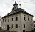 Old school in Ohren
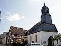 Neesbach church
 Kirberg castle ruins
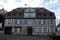 Former town hall of Kirberg
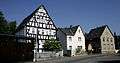 Row of buildings in Dauborn
Museums
- Heimatmuseum (local lore) in Kirberg.
Economy and infrastructure
Transport
Hünfelden has developed itself into a popular residential community, as it has at its disposal good transport connections with Wiesbaden and Limburg an der Lahn (Bundesstraße 417) as well as with the Frankfurt Rhein-Main Region over A 3 (Cologne–Frankfurt) through the Limburg-Süd and Bad Camberg interchanges. At the same time, though, it has kept a very quiet and rural character.
Education
The Freiherr-vom-Stein-Schule is a primary school, Hauptschule and Realschule with a Gymnasium branch.
Public institutions
- Kindergarten Kirberg
- Kindergarten Dauborn
- Kindergarten Heringen
- Kindergarten Mensfelden
- Kindergarten Nauheim
- Kindergarten Neesbach
- Kindergarten Ohren
- Kirberg Volunteer Fire Brigade, founded 1905 (includes Youth Fire Brigade)
- Dauborn Volunteer Fire Brigade, founded 1906 (includes Youth Fire Brigade)
- Heringen Volunteer Fire Brigade, founded 1909 (includes Youth Fire Brigade)
- Mensfelden Volunteer Fire Brigade, founded 1935 (includes Youth Fire Brigade)
- Nauheim Volunteer Fire Brigade, founded 1934 (includes Youth Fire Brigade)
- Neesbach Volunteer Fire Brigade, founded 1934 (includes Youth Fire Brigade)
- Ohren Volunteer Fire Brigade, founded 1934 (includes Youth Fire Brigade)
Famous people
- Wilhelm Bender, Chairman of the board of Fraport AG
- Frank Gerhardt, composer (b. 1967)
- Andreas Felger, painter (b. 1935)
- Hildegard Pfaff, (b. 1952), Hessian politician (SPD)
- Karlheinz Weimar (b. 1950), since 1999 Hessian Finance Minister
References
- ↑ "Bevölkerung der hessischen Gemeinden". Hessisches Statistisches Landesamt (in German). August 2016.
External links
| Wikimedia Commons has media related to Hünfelden. |
Towns and municipalities in Limburg-Weilburg | ||
|---|---|---|