Hallett Cove, South Australia
| Hallett Cove Adelaide, South Australia | |||||||||||||
|---|---|---|---|---|---|---|---|---|---|---|---|---|---|
 | |||||||||||||
 Hallett Cove | |||||||||||||
| Coordinates | 35°04′37″S 138°30′07″E / 35.077°S 138.502°ECoordinates: 35°04′37″S 138°30′07″E / 35.077°S 138.502°E | ||||||||||||
| Population | 12,272 (2006 census)[1] | ||||||||||||
| • Density | 1,215/km2 (3,147/sq mi) | ||||||||||||
| Postcode(s) | 5158 | ||||||||||||
| Area | 10.1 km2 (3.9 sq mi) | ||||||||||||
| Location | 21 km (13 mi) from Adelaide | ||||||||||||
| LGA(s) | City of Marion | ||||||||||||
| State electorate(s) | Bright | ||||||||||||
| Federal Division(s) | Kingston | ||||||||||||
| |||||||||||||
Hallett Cove is a coastal suburb in the south of Adelaide, South Australia, with a population of more than 12,000 people. Adjoining suburbs are Marino to the north, Trott Park and Sheidow Park to the east and Lonsdale to the south. It is within the City of Marion local government area. The Hallett Cove Shopping Centre is the suburb's largest shopping centre, and has recently undergone a major redevelopment. New features include underground parking, a food court, a Big W department store and a Woolworths supermarket in addition to the Drake Foodmarkets owned Foodland already in place.
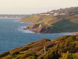
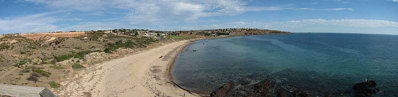
Hallett Cove itself is a small rocky beach, named after John Hallett, who came across it in 1837 whilst searching for missing stock.[2] The Field River runs out to sea at the southern end. The cliffs to the north are part of the Hallett Cove Conservation Park, featuring Aboriginal artefacts used by the Kaurna tribe and several significant geological features. These include glacial striations on the clifftop discovered by Professor Ralph Tate in 1877, which along with similar striations found earlier at Selwyn's Rock at Inman Valley, 40 km (25 mi) to the south in 1859, provide evidence for the Permian glaciation of southern Australia, then part of Gondwana. There are also a number of large glacial erratics on the beach.[3]
Schools
The suburb features three schools, Hallett Cove School (R-12) which was established in 1987 and is situated in the middle of the suburb. Hallett Cove East Primary School (R-7) exists in the Karrara estate on the northern side of the suburb. The Hallett Cove South School (R-7) is the oldest school in the suburb and is situated near the Hallett Cove School (R-12).
Transport
Hallett Cove railway station is on top of the cliffs to the north of the beach, and services the greater Hallett Cove area. Originally the line ran inland from there to Reynella and ultimately to Willunga but the section from Hallett Cove onwards was closed in the 1960s. The Coast to Vines rail trail is a shared bike/pedestrian path that now follows the old line. A new railway extension was built south along the coast to Noarlunga; Hallett Cove Beach is the first station on this line. Both stations underwent a refurbishment in 2011, giving them a more modern look.
Bus routes serviced by the Adelaide Metro run through Hallett Cove, terminating at the Hallett Cove Shopping Centre and Hallett Cove Beach Station. Routes include:
- 720: Old Reynella Interchange - Sheidow Park - Hallett Cove Shopping Centre - Marion Shopping Centre - Adelaide
- 720H: Old Reynella Interchange - Sheidow Park - Hallett Cove Shopping Centre - Marion Shopping Centre - Flinders Medical Centre - Adelaide
- 681 : Hallett Cove Beach - Hallett Cove Shopping Centre - Marion Shopping Centre - Flinders University
- 681A : Hallett Cove Beach - Hallett Cove Shopping Centre - Hallett Cove North
- 682: Hallett Cove Beach - Hallett Cove Shopping Centre - Sheidow Park
- 683: Hallett Cove Beach - Hallett Cove South
See also
References
| Wikimedia Commons has media related to Hallett Cove, South Australia. |
- ↑ Australian Bureau of Statistics (25 October 2007). "Hallett Cove (State Suburb)". 2006 Census QuickStats. Retrieved 30 June 2007.
- ↑ "The History of the Hallett Cove Conservation Park". Friends of Hallett Cove. 12 September 2007. Retrieved 27 July 2009.
- ↑ McBriar, E.M. & Mooney, P.A. (Eds. 1977): Geological Monuments in South Australia, Part 1. Geological Monuments Subcommittee of the S.A Division of the Geological Society of Australia Inc. pp32-39.