Hana Airport
| Hana Airport Kahua Mokulele o Hāna | |||||||||||
|---|---|---|---|---|---|---|---|---|---|---|---|
 | |||||||||||
| IATA: HNM – ICAO: PHHN – FAA LID: HNM | |||||||||||
| Summary | |||||||||||
| Airport type | Public | ||||||||||
| Owner | Hawaii Department of Transportation | ||||||||||
| Serves | Hana, Hawaii | ||||||||||
| Elevation AMSL | 78 ft / 24 m | ||||||||||
| Coordinates | 20°47′44″N 156°00′52″W / 20.79556°N 156.01444°WCoordinates: 20°47′44″N 156°00′52″W / 20.79556°N 156.01444°W | ||||||||||
| Website | hawaii.gov/hnm | ||||||||||
| Map | |||||||||||
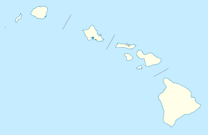 HNM Location of airport in Hawaii | |||||||||||
| Runways | |||||||||||
| |||||||||||
| Statistics (2009) | |||||||||||
| |||||||||||
Hana Airport (IATA: HNM, ICAO: PHHN, FAA LID: HNM) is a regional public use airport of the State of Hawaiʻi on the east shore of the island of Maui, 3 nautical miles (5.6 km) northwest[1] of the unincorporated town of Hana. The airport was officially opened on November 11, 1950.[2] It is primarily a commuter facility used by unscheduled air taxis and general aviation. As air traffic increases, the Hawaiʻi State Legislature will consider future improvements including the construction of a taxiway paralleling the runway, widening of access roads and expansion of passenger terminals and parking facilities.


Scheduled commercial airline service provided Pacific Wings was subsidized by the Essential Air Service program until April 1, 2007, when Pacific Wings began providing subsidy-free service;[3] however, with fares as high as $200 each way, most travelers opted to drive rather than fly. According to U.S. Department of Transportation data, Pacific Wings transported only 375 passengers in the first 10 months of 2012, while Mokulele Airlines claims to have transported 1706 passengers since October 2012, according to their EAS bid for Kamuela service on May 23, 2013.
As per Federal Aviation Administration records, the airport had 1,462 passenger boardings (enplanements) in calendar year 2008,[4] 682 enplanements in 2009, and 132 in 2010.[5] It is included in the National Plan of Integrated Airport Systems for 2011–2015, which categorized it as a general aviation airport.[6]
Facilities and aircraft
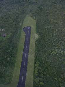
Hana Airport covers an area of 119 acres (48 ha) at an elevation of 78 feet (24 m) above mean sea level. It has one runway designated 8/26 with an asphalt surface measuring 3,606 by 100 feet (1,099 x 30 m).[1]
For the 12-month period ending December 31, 2009, the airport had 4,482 aircraft operations, an average of 12 per day: 45% general aviation, 29% air taxi, 26% scheduled commercial, and <1% military.[1]
Airlines and destinations
The following airlines offer scheduled passenger service:
| Airlines | Destinations |
|---|---|
| Mokulele Airlines | Kahului |
Authority
Hana Airport is part of a centralized state structure governing all of the airports and seaports of Hawaiʻi. The official authority of Hana Airport is the Governor of Hawaiʻi. He or she appoints the Director of the Hawai'i State Department of Transportation who has jurisdiction over the Hawaiʻi Airports Administrator.
The Hawaiʻi Airports Administrator oversees six governing bodies: Airports Operations Office, Airports Planning Office, Engineering Branch, Information Technology Office, Staff Services Office, Visitor Information Program Office. Collectively, the six bodies have authority over the four airport districts in Hawaiʻi: Hawai'i District, Kauaʻi District, Maui District and the principal Oʻahu District. Hana Airport is a subordinate of the Maui District officials.
Media appearances
Hana Airport is the destination in the "Hawaiian Checkout" mission supplied with Microsoft Flight Simulator X.
References
- 1 2 3 4 FAA Airport Master Record for HNM (Form 5010 PDF). Federal Aviation Administration. Effective April 5, 2012.
- ↑ "Hana Airport". Hawaiian Aviation. Retrieved April 13, 2015.
- ↑ "Order 2006-12-3: Pacific Wings to provide subsidy-free EAS beginning April 1, 2007". U.S. Department of Transportation. 2006-12-07.
- ↑ "Enplanements for CY 2008" (PDF, 1.0 MB). CY 2008 Passenger Boarding and All-Cargo Data. Federal Aviation Administration. December 18, 2009. External link in
|work=(help) - ↑ "Enplanements for CY 2010" (PDF, 189 KB). CY 2010 Passenger Boarding and All-Cargo Data. Federal Aviation Administration. October 4, 2011. External link in
|work=(help) - ↑ "2011–2015 NPIAS Report, Appendix A" (PDF, 2.03 MB). National Plan of Integrated Airport Systems. Federal Aviation Administration. October 4, 2010. External link in
|work=(help)
Other sources
- Essential Air Service documents (Docket OST-1999-6502) from the U.S. Department of Transportation:
- Order 2005-3-34: re-selecting Pacific Wings Airlines to provide essential air service (EAS) at Hana, Kalaupapa, and Kamuela, Hawaii, for the period from April 1, 2005, through March 31, 2007, at an annual rate of $1,597,422 for the first year and at an annual rate of $1,501,752 for the second year.
- Order 2006-12-3: terminating the carrier-selection proceeding for Essential Air Service at Hana, Kalaupapa, and Kamuela, Hawaii. The incumbent EAS carrier, Pacific Wings, has proposed to continue to provide all three communities' EAS on a subsidy-free basis beginning April 1, 2007.
External links
| Wikimedia Commons has media related to Hana Airport. |
- Hana Airport page at Hawaii DOT
- FAA Terminal Procedures for HNM, effective December 8, 2016
- Resources for this airport:
- FAA airport information for HNM
- AirNav airport information for PHHN
- ASN accident history for HNM
- FlightAware airport information and live flight tracker
- NOAA/NWS latest weather observations for PHHN
- SkyVector aeronautical chart for HNM