Hankley Common
Hankley Common is a common near Elstead, Surrey, England. It is an area of heathland with sandy infertile soil. The dry areas are covered in common heather (Calluna vulgaris) and bell heather (Erica cinerea) with patches of bracken (Pteridium aquilinum)
Hankley Common is a designated Site of Special Scientific Interest (SSSI).[1]
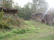
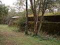
Atlantic Wall reconstruction
D-Day training sites were created in Britain in order to practice for Operation Overlord, the invasion of Northern France by allied forces in 1944.
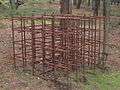
In 1943, in an area of the common known as the Lion's Mouth, Canadian troops constructed a replica of a section of the Atlantic Wall. It is constructed from reinforced concrete and was used as a major training aid to develop and practise techniques to breach the defences of the French coast prior to the D-Day landings.[2]
The wall is about 100 m (330 ft) long, 3 m (9.8 ft) high by 3.5 m (11 ft) wide. It is divided into two sections between which there were originally steel gates. Nearby are other obstacles such as dragon's teeth, reinforced concrete blocks and lengths of railway track set in concrete and with wire entanglements. Many of the relics show signs of live weapons training and the main wall has two breaches caused by demolition devices including the Double Onion: a specialised demolition vehicle, one of Hobart's Funnies, based on the Churchill tank.[3][4]
The reinforced concrete was made with rebars varying from 10 to 20 mm (0.39 to 0.79 in) thick.
Over the years the wall has become colonised by alkaline-loving lichens, mosses, ferns and other plants because the concrete provides the lime-based substrate that these species require and which is found nowhere else in the locality. They present an unusual range of plants to be found in an expanse of acid heathland.
The preservation of the Wall is managed by Army Training Estates with the assistance of the MOD Hankley Conservation Group.


Golf course
Hankley Common is home to one of Britain's most popular golf courses.[5] Hankley Common Golf Club opened in 1897 with nine holes and was expanded to eighteen holes in 1922. [6]
Film and television
Hankley Common was also used in the James Bond films The World Is Not Enough, Die Another Day, and Skyfall. The sets depicted a pier in the Caspian Sea where James Bond was attacked by a helicopter saw, a chase scene through the Korean Demilitarized Zone on hovercraft, and as the site of James Bond's ancestral Scottish mansion respectively.[7]
Hankley Common has been popular with fictional time travellers having featured in Doctor Who and the Silurians[8] and in Blackadder Back and Forth.[9]
In the fourth series of Ultimate Force, the Drop Zone huts and surrounding area were used to shoot a Colombian forces training camp.
Tenko was also filmed on the common.[10]
Bayne Bossom air crash
In July 1932 a Puss Moth aircraft carrying Emily Bayne Bossom, Bruce Bayne Bossom and Count Otho Erbach-Fürstenau broke up in mid air and at least two of the occupants fell to the ground on Hankley Common. The sites where they fell are marked with memorial stones.[11]
The Wigwam Murder
In 1942, Hankley Common was the site of a murder. The victim was a woman who was living rough in a crude shelter made of tree branches in the manner of a wigwam, and so the newspapers gave her the nickname of "Wigwam Girl". She was eventually identified as Joan Pearl Wolfe.
Notes
- ↑ "Thursley, Hankley and Frensham Commons" (PDF). Retrieved 4 December 2006.
- ↑ Image of Hankley Common dedication plaque.
- ↑ Hankley Common Trials - WO 195/4238. The Catalogue, The National Archives
- ↑ http://www.shepheard.plus.com/atlanticwall/ A Sea Wall in Surrey?.
- ↑ "Hankley common, England". Top 100 Gold Courses of the World. Retrieved 4 December 2006.
- ↑ "Hankley common Golf Club". Retrieved 13 October 2013.
- ↑ http://www.britannia.org/Film/filmdetails/00000330[]
- ↑ "Hankley Common". Doctor Who - The Locations Guide. Retrieved 17 September 2013.
- ↑ "Blackadder filming on Hankley Common". Blackadder Hall. Archived from the original on 5 October 2006. Retrieved 28 October 2006.
- ↑ Bomb alert hits 'Tenko' beauty spot
- ↑ http://www.geograph.org.uk/photo/968998
References
- The National Archives - repository of UK government records.
- WW2 People's War is an online archive of wartime memories contributed by members of the public and gathered by the BBC. The archive can be found at http://bbc.co.uk/ww2peopleswar.
- Lunn, Arthur (6 April 2007). "Murdered in the heroes 'drop' zone". The News.
Further reading
- William Foot. The Battlefields That Nearly Were: Defended England, 1940. Stroud: Tempus Publishing, 2006. ISBN 0-7524-3849-2.
External links
- Hankley and Elstead Commons (MOD)
- Hankley & Elstead Commons (Surrey Wildlife Trust)
- A Sea Wall in Surrey? - D-Day preparations on Hankley Common
- http://www.culture24.org.uk/spliced/pictures/art22136
- Hankley Common, Surrey
- Thursley, Hankley and Frensham Commons, SSSI notification
Coordinates: 51°09′53″N 0°44′09″W / 51.1646°N 0.7357°W