Law Brook, Surrey
| Law Brook | |
| Postford Brook | |
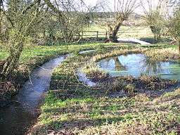 Law Brook flowing westwards from the hamlet of Brook towards Postford | |
| Country | England |
|---|---|
| County | Surrey |
| Borough | Guildford Borough |
| Source | Gasson Farm, The Hurtwood and sources in Peaslake proper |
| - location | Peaslake, Shere, Borough of Guildford |
| - elevation | 148 m (486 ft) |
| - coordinates | 51°11′02″N 0°26′38″W / 51.18389°N 0.44389°W |
| Mouth | River Tillingbourne |
| - location | Colyers Hanger, Albury (foot), Borough of Guildford |
| - elevation | 50 m (164 ft) |
| - coordinates | 51°13′20″N 0°31′00″W / 51.22222°N 0.51667°WCoordinates: 51°13′20″N 0°31′00″W / 51.22222°N 0.51667°W |
| Discharge | for Albury [1] |
| - average | 0.11 m3/s (4 cu ft/s) |
| - max | 0.8 m3/s (28 cu ft/s) (15 September 1968) |
| - min | 0.05 m3/s (2 cu ft/s) (4 August 1992) |
The Law Brook or Postford Brook is a Surrey stream, a tributary of the Tillingbourne which in turn flows into the River Wey. It is notable in its own right chiefly for its industrial heritage.
Course
The stream is about 7 km long and flows in a generally NW direction towards the Vale of Holmesdale. It rises at various sources above Peaslake on the northern slopes of the Greensand Ridge. It drains the northern Winterfold Forest/Hurtwood Forest: the upper half of the catchment area is mostly forest with some pasture other than Peaslake. The lower course flows between the clustered village of Brook/Little London in Albury on the right bank, and Blackheath, a sparsely-inhabited wooded plateau, on the left bank.[1]
It forms part of the boundary between the civil parishes of Albury and St Martha which contains most of Chilworth.[2] Like the Tillingbourne, the lower Law Brook was harnessed by the construction of leats (narrow cuts) and mill ponds to provide power for industrial mills, including a long leat dividing Chilworth and supplying its largest pond, known today as The Fish Pond, Chilworth.[3]
The North Downs Line runs roughly parallel to the Brook for about 2 km.
References
- 1 2 Marsh, T; Hannaford, J, eds. (2008). UK Hydrometric Register (PDF). Hydrological data UK series. Wallingford, Oxfordshire: Centre for Ecology & Hydrology. ISBN 978-0-9557672-2-7.
- ↑ Crocker, Glenys; Crocker, Alan (2000). Damnable Inventions: Chilworth Gunpowder and the Paper Mills of the Tillingbourne. Guildford: Surrey Industrial History Group. pp. 1–3. ISBN 0-9538122-0-0.
- ↑ Royal Gunpower Mills Newsletter 24. Accessed 2015-04-10.