Hanover Township, Shelby County, Indiana
| Hanover Township | |
|---|---|
| Township | |
 | |
| Coordinates: 39°40′09″N 85°40′44″W / 39.66917°N 85.67889°WCoordinates: 39°40′09″N 85°40′44″W / 39.66917°N 85.67889°W | |
| Country | United States |
| State | Indiana |
| County | Shelby |
| Government | |
| • Type | Indiana township |
| Area | |
| • Total | 27.33 sq mi (70.8 km2) |
| • Land | 27.21 sq mi (70.5 km2) |
| • Water | 0.12 sq mi (0.3 km2) |
| Elevation[1] | 883 ft (269 m) |
| Population (2010) | |
| • Total | 2,283 |
| • Density | 83.9/sq mi (32.4/km2) |
| FIPS code | 18-31270[2] |
| GNIS feature ID | 453372 |
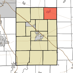
Hanover Township is one of fourteen townships in Shelby County, Indiana. As of the 2010 census, its population was 2,283 and it contained 962 housing units.[3]
Hanover Township was organized before 1840.[4]
Geography
According to the 2010 census, the township has a total area of 27.33 square miles (70.8 km2), of which 27.21 square miles (70.5 km2) (or 99.56%) is land and 0.12 square miles (0.31 km2) (or 0.44%) is water.[3]
Cities and towns
Unincorporated towns
References
- ↑ "US Board on Geographic Names". United States Geological Survey. 2007-10-25. Retrieved 2008-01-31.
- ↑ "American FactFinder". United States Census Bureau. Retrieved 2008-01-31.
- 1 2 "Population, Housing Units, Area, and Density: 2010 - County -- County Subdivision and Place -- 2010 Census Summary File 1". United States Census. Retrieved 2013-05-10.
- ↑ History of Shelby County, Indiana: From the Earliest Time to the Present, with Biographical Sketches, Notes, Etc. Brant & Fuller. 1887. p. 277.
External links
Municipalities and communities of Shelby County, Indiana, United States | ||
|---|---|---|
| City | ||
| Towns | ||
| Townships | ||
| CDP | ||
| Other unincorporated communities |
| |
| Footnotes | ‡This populated place also has portions in an adjacent county or counties | |
This article is issued from Wikipedia - version of the 11/17/2016. The text is available under the Creative Commons Attribution/Share Alike but additional terms may apply for the media files.