Hatfield Center Historic District
"Hatfield Center" redirects here. For demographic information on Hatfield Center, see Hatfield (CDP), Massachusetts. For the building at NIH, see National Institutes of Health Clinical Center.
|
Hatfield Center Historic District | |
|
Center School | |
  | |
| Location | Hatfield, Massachusetts |
|---|---|
| Coordinates | 42°21′43″N 72°36′1″W / 42.36194°N 72.60028°WCoordinates: 42°21′43″N 72°36′1″W / 42.36194°N 72.60028°W |
| Built | 1677 |
| Architectural style | Late 19th And 20th Century Revivals, Mid 19th Century Revival, Colonial |
| NRHP Reference # | [1] |
| Added to NRHP | July 27, 1994 |
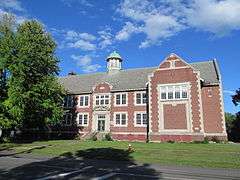
The Hatfield Center Historic District encompasses the traditional center of Hatfield, Massachusetts. The area, first laid out in 1661, is bounded by Maple Street to the south, the Connecticut River to the east, Day Avenue and School Street to the north, and the Mill River to the west. The district abuts the Elm Street and the Mill-Prospect Street Historic Districts to the west. Main Street, the principal north-south road in the district is characterized by well-spaced residential lots containing homes built in the 18th and 19th centuries, and the civic heart of the town, where the town hall, Center School, and Memorial Hall are located.[2]
The district was added to the National Register of Historic Places in 1994.[1]
See also
- National Register of Historic Places listings in Hampshire County, Massachusetts
- Bradstreet Historic District
- North Hatfield Historic District
- West Hatfield Historic District
- Upper Main Street Historic District (Hatfield, Massachusetts)
References
- 1 2 National Park Service (2008-04-15). "National Register Information System". National Register of Historic Places. National Park Service.
- ↑ "Hatfield Heritage Survey" (PDF). Massachusetts DCR via Hatfield Historical Society. Retrieved 2013-12-19.
| Topics |  | ||||||||||||||||||||||||||||||
|---|---|---|---|---|---|---|---|---|---|---|---|---|---|---|---|---|---|---|---|---|---|---|---|---|---|---|---|---|---|---|---|
| Lists by county | |||||||||||||||||||||||||||||||
| Lists by city |
| ||||||||||||||||||||||||||||||
| Other lists | |||||||||||||||||||||||||||||||
| |||||||||||||||||||||||||||||||
This article is issued from Wikipedia - version of the 11/27/2016. The text is available under the Creative Commons Attribution/Share Alike but additional terms may apply for the media files.