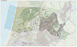
Heemskerk
| Heemskerk | |||
|---|---|---|---|
| Municipality | |||
|
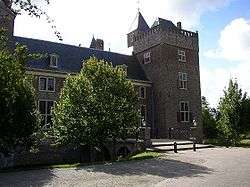
Assumburg castle in Heemskerk | |||
| |||
.svg.png) Location in North Holland | |||
| Coordinates: 52°31′N 4°40′E / 52.517°N 4.667°ECoordinates: 52°31′N 4°40′E / 52.517°N 4.667°E | |||
| Country | Netherlands | ||
| Province | North Holland | ||
| Government[1] | |||
| • Body | Municipal council | ||
| • Mayor | Mieke Baltus (CDA) | ||
| Area[2] | |||
| • Total | 31.67 km2 (12.23 sq mi) | ||
| • Land | 27.26 km2 (10.53 sq mi) | ||
| • Water | 4.41 km2 (1.70 sq mi) | ||
| Elevation[3] | 2 m (7 ft) | ||
| Population (May 2014)[4] | |||
| • Total | 39,078 | ||
| • Density | 1,434/km2 (3,710/sq mi) | ||
| Demonym(s) | Heemskerker | ||
| Time zone | CET (UTC+1) | ||
| • Summer (DST) | CEST (UTC+2) | ||
| Postcode | 1960–1969 | ||
| Area code | 0251 | ||
| Website |
www | ||


Heemskerk (![]() pronunciation ) is a municipality and a town in the Netherlands, in the province of North Holland. It is located in the Kennemerland region.
pronunciation ) is a municipality and a town in the Netherlands, in the province of North Holland. It is located in the Kennemerland region.
Local government
As of March 2014, the municipal council of Heemskerk consists of 25 seats, which are divided as follows:
- Christian Democratic Appeal - 5 seats
- Heemskerk Lokaal - 5 seats
- Liberaal Heemskerk - 5 seats
- Democrats 66 - 4 seats
- Labour Party - 4 seats
- Green Left- 2 seats
The CDA, Heemskerk Lokaal, Liberaal Heemskerk and D66 form the governing coalition. The (non-elected) mayor of Heemskerk is currently Mieke Baltus (CDA).
History
It is not certain where the name of Heemskerk comes from. The town was already known during the Middle Ages. In an official deed from the year of 1063, the town was known as Hemezen Kyrica, Latinized Frisian meaning Church of Hemezen, a Frisian nun who lived in a religious house there. Heemskerk knows many historical monuments, among them the Huldtoneel (lit. the "Inaugurate Stage"), an artificial hill located near the current Rijksstraatweg, where once the Counts of Holland where inaugurated. According to tradition, the Huldtoneel was used before the Roman Era as a Germanic sanctuary. In the nineteenth century Jonkheer Gevers finally made the Huldtoneel a monument - as it is known today - and ordered passers-by to honour the monument.
Many battles have been fought in Heemskerk. Two castles - Castle Oud Haerlem and Castle Heemskerk - were built in the twelfth and thirteenth century respectively to protect the County of Holland against the West Frisians. In the fifteenth century the residents of Heemskerk fought each other during the Hook and Cod wars, in which both castles were destroyed. The Oud Haerlem castle was never rebuilt, Castle Heemskerk however was. In 1492 a rebellion by the people of Kennemerland was brutally beaten down by the Austrian conquerors, on the place where today the cemetery of the Hervormde Kerk (Reformed Church) is located.
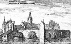
In 1610 the Castle Heemskerk was renamed to Castle Marquette and was at first the residence for many nobles and later inhabited by patricians. The last noble family that lived there were the House of Gevers. Today Castle Marquette is owned by the Spanish hotelgroup NH Hoteles and is the site of many weddings, conferences, and company courses, while the estate grounds are favoured for wedding photos.
Located on the eastside of Heemskerk is Castle Assumburg, built from the remains of Kasteel Oud Haerlem in 1546. The Nederlandse Hervormde Kerk (Dutch Reformed Church) at the Nielenplein and Kerkplein is built in 1628, but it has a tower from the Middle Ages. In the graveyard around the church is a copy of a monument dedicated to the father of painter Maarten van Heemskerck. The original is located inside the church.
Agricultural village
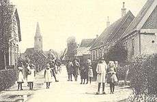
After the time of knights and nobles, Heemskerk remained a small, quiet village near the dunes. Its residents, who mainly worked in agriculture and keeping cattle, had good, but also some very bad times. From the time that products - mainly strawberries for the neighbouring town Beverwijk, where the fruits were sold - were brought to the market with donkeys, people from Heemskerk got the name of Donkey as a nickname and symbol.
The former town hall was built in 1911 after a design by Jan Stuyt and was raised with an additional floor in 1949. Today this is the building where Janssen's notary office is located. The Roman Catholic Laurentiuskerk, designed by architect J.H. Tonnaer, was completed in 1891 and is a rare example of a Catholic church in neo-renaissance style. There is nothing left of other historical monuments, like Castle Oud Haerlem.
Transportation
- Railway Station: Heemskerk
Notable residents
- Maarten van Heemskerck (1498 - 1574), painter.
- Ernesto Fritz Hoost "Mr Perfect" (11 July 1965), kickboxer: four-time K-1 World Champion
- Bart Schraa (22 November 1968), football player: Bayer Leverkusen, FC Schalke 04, Arminia Bielefeld.
- Arthur Numan (14 December 1969), football player: HFC Haarlem, FC Twente, PSV, Rangers.
- Peter Wijker (20 July 1971), football player: AZ, FC Volendam.
- Dennis Lens (25 September 1977), badminton player.
- Raymond Bronckhorst (6 August 1978), football player: FC Groningen, SC Cambuur.
- Rafael van der Vaart (11 February 1983), football player: AFC Ajax, Hamburger SV, Real Madrid and Tottenham Hotspur
- Julián Contreras (3 May 1983), football player: CD Buenavista (Spain)
- Sofie van den Enk (23 August 1980), television presenter
- Bette Franke, (3 December 1989), model
- Pelle van Amersfoort (1 April 1996), football player
References
- ↑ "De burgemeester van Heemskerk" [The mayor of Heemskerk] (in Dutch). Gemeente Heemskerk. Retrieved 5 March 2014.
- ↑ "Kerncijfers wijken en buurten" [Key figures for neighbourhoods]. CBS Statline (in Dutch). CBS. 2 July 2013. Retrieved 12 March 2014.
- ↑ "Postcodetool for 1964EZ". Actueel Hoogtebestand Nederland (in Dutch). Het Waterschapshuis. Retrieved 5 March 2014.
- ↑ "Bevolkingsontwikkeling; regio per maand" [Population growth; regions per month]. CBS Statline (in Dutch). CBS. 26 June 2014. Retrieved 24 July 2014.
- ↑ J. Van Venetien (1968). Hart van Kennemerland: Album van het leven en werken in Midden-Kennemerland door de eeuwen heen. p.212.
External links
 Media related to Heemskerk at Wikimedia Commons
- Official website
 |
Castricum | Uitgeest | | |
| North Sea | |
|||
| ||||
| | ||||
| Beverwijk | Zaanstad |
