West Friesland (region)
- For the historical region also named West Friesland, see West Friesland (historical region)
Not to be confused with the West Friesland Dutch dialect.
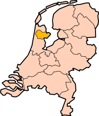
West Friesland (also West Frisia;Dutch: West-Fryslân) is a contemporary region in the Northwest of the Netherlands, in the province of North Holland.
History


The River Vlie (also called Fli) is an extension of the IJssel branch of the Rhine River. The River Vlie divides the northern Netherlands into two parts - the western and the eastern part. In the eleventh century, when northern Netherlands was part of Western Frisia, heavy rainfall caused the river to flood over large parts of the land. The Zuiderzee bay (previously a lake) was formed, separating West Friesland from the contemporary Province of Friesland.[1] In the Middle Ages, the Westflinge area of West Friesland became an island, bordered on the north by the Medem and Zijpe inlets, and to the south by various interconnecting lakes (now polder land) that were connected with the Zuiderzee. Because of this, the toponym "West Friesland" was applied more to the Westflinge area than to the original West Friesland.
For approximately 300 years, West Friesland operated as an autonomous area as the West Frisians did not wish to be vassals of lords from Holland. Floris V, Count of Holland, attempted to unite Holland and West Friesland during his reign and he succeeded in annexing West Frisia.[2] It was his successor, John I, who achieved ultimate victory over the West Frisians in 1297. West Friesland formed a united province with Holland in the Dutch Republic, though it was recognized an autonomous region, and the parliament of said province, commonly known as Holland, was formally known as the States of Holland and West Friesland. During the time of the United Provinces, West Friesland had its own independent Admiralty of the Northern Quarter. Any admiral serving within this admiralty or the two other Hollandic admiralties (Amsterdam and the Admiralty of de Maze) had the title of Admiral of Holland and West Frisia.
The West Frisian language has disappeared from the region[1] and the later West Frisian dialects are now slowly disappearing. Although these dialects are subdialects of Hollandic Dutch, they were strongly influenced in vocabulary and grammar by a West Frisian substratum.
Early Medieval Vroonen
The first inhabitants of Alkmaar, Oudorp, and St Pancras likely settled along the high beach ridges of the Vroonermeer in the 9th century AD. Better known as Vroonen, this settlement subsequently grew into a village. In the late 13th century, when West Frisians were conquered by the Dutch, the victors crossed the village and set it on fire. The few surviving inhabitants fled the region. After a long time, people returned to Vroonen and a chapel was built. The village of St Pancras was founded around this church [1484].
Vroonermeer was drained in 1561.
The reclamation of the North Holland lakes was a purely private business affair intended for the establishment of new tracts of fertile land. Investors financed the operation and leased their new land to farmers.
Geography
The exact location of West Friesland is not clearly defined, but it has been suggested that it comprised the area north of an imaginary line through Hoorn and Alkmaar.[3] Within this historical region is the contemporary region of West Friesland, a smaller area based on a dyke system on the Westfriese Omringdijk that lay in West Friesian district (gouw) of Westflinge.
The area between the rivers Vlie and IJ consists of the present-day municipalities of Alkmaar, Amsterdam (Landelijk Noord), Beemster, Bergen, Castricum, Den Helder, Drechterland, Edam-Volendam, Enkhuizen, Heerhugowaard, Heiloo, Hollands Kroon, Hoorn, Koggenland, Landsmeer, Langedijk, Medemblik, Purmerend, Oostzaan, Opmeer, Schagen, Stede Broec, Texel, Uitgeest, Vlieland, Waterland, Wognum, Wormerland, and Zaanstad.
(Former) municipalities
The region covers an area of about 800 km2 (309 sq mi), delineated by the Westfriese Omringdijk. It consists of the following (former) municipalities:
| Dutch name | West Frisian Name |
| Alkmaar | Alkmar |
| Andijk | Andoik [4] |
| Drechterland | Drechterland |
| Enkhuizen | Henkhúze |
| Harenkarspel | Harenkarspel [5] |
| Heerhugowaard | Heerhugoweerd or Heregeweerd |
| Hoorn | Hoorn |
| Koggenland | Koggeland |
| Langedijk | Lengedoik |
| Medemblik | Memeloik |
| Niedorp | Nierup [6] |
| Opmeer | Obmar or Opmar |
| Schagen | Skagen |
| Stede Broec | Stee Broek |
| Venhuizen | Venhûze [7] |
| Wervershoof | Wurrevershouf [4] |
Major cities include Hoorn (which was the capital of West-Friesland) and Alkmaar.
Dialect
The traditional dialect of the region is the West Frisian dialect of Hollandic Dutch. The contemporary region is similar in size and location to the historical district (gouw) of Westflinge which itself was a part of a much larger historical region of West Friesland.
-

Westfrisian flag
See also
References
- 1 2 Reinhardt, Andreas, ed. (1984). Die erschreckliche Wasser-Fluth 1634 (in German). Husum: Husum Druck- und Verlagsgesellschaft. p. 189. ISBN 3-88042-257-5.
- ↑ Delaissé, L. M. J. (1968). A Century of Dutch Manuscript Illumination. California Studies in the History of Art. University of California Press and Cambridge University Press. p. 5.
- ↑ van Nierop, Henk (2009). Treason in the Northern Quarter: War, Terror, and the Rule of Law in the Dutch Revolt. Princeton University Press. p. 10. ISBN 9780691135649.
- 1 2 Former municipality, since 2011 part of Medemblik.
- ↑ Former municipality, since 2013 part of Schagen.
- ↑ Former municipality, since 2012 part of Hollands Kroon.
- ↑ Former municipality, since 2006 part of Drechterland.
External links
- The region website (in Dutch and partly Westfrisian)
Coordinates: 52°41′N 5°00′E / 52.683°N 5.000°E