Den Helder
| Den Helder | |||
|---|---|---|---|
| Municipality | |||
|
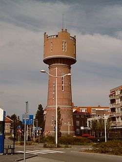
Water tower of Den Helder | |||
| |||
.svg.png) Location in North Holland | |||
| Coordinates: 52°56′N 4°45′E / 52.933°N 4.750°ECoordinates: 52°56′N 4°45′E / 52.933°N 4.750°E | |||
| Country | Netherlands | ||
| Province | North Holland | ||
| Government[1] | |||
| • Body | Municipal council | ||
| • Mayor | Koen Schuiling (VVD) | ||
| Area[2] | |||
| • Total | 178.80 km2 (69.04 sq mi) | ||
| • Land | 45.25 km2 (17.47 sq mi) | ||
| • Water | 133.55 km2 (51.56 sq mi) | ||
| Elevation[3] | 1 m (3 ft) | ||
| Population (2016)[4] | |||
| • Total | 56,308 | ||
| • Density | 1,249/km2 (3,230/sq mi) | ||
| Demonym(s) | Heldenaar | ||
| Time zone | CET (UTC+1) | ||
| • Summer (DST) | CEST (UTC+2) | ||
| Postcode | 1780–1789 | ||
| Area code | 0223 | ||
| Website |
www | ||


Den Helder (![]() pronunciation ) is a municipality and a city in the Netherlands, in the province of North Holland. Den Helder occupies the northernmost point of the North Holland peninsula. It is home to the country's main naval base.
From here the Royal TESO ferryboat service operates the transportation link between Den Helder and the nearby Dutch Wadden island of Texel to the north.
pronunciation ) is a municipality and a city in the Netherlands, in the province of North Holland. Den Helder occupies the northernmost point of the North Holland peninsula. It is home to the country's main naval base.
From here the Royal TESO ferryboat service operates the transportation link between Den Helder and the nearby Dutch Wadden island of Texel to the north.
Population centres
The municipality of Den Helder consists of the following cities, towns, villages and/or districts: Den Helder, Huisduinen, Julianadorp, and the hamlets Friese Buurt and De Kooy.
The major areas of Den Helder are Old Den Helder, Nieuw-Den Helder, and De Schooten. Nieuw-Den Helder was built in the 1950s, following World War II, when there was a great need for additional housing. De Schooten was constructed in the 1960s.
Topography
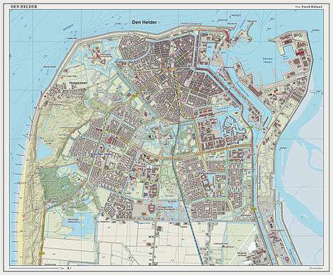
Dutch Topographic map of Den Helder (town), March 2014.
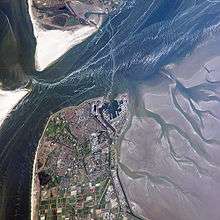 Satellite image (May 2007) |
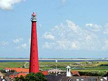 Lange Jaap lighthouse |

History
Huisduinen was the original older part of the city, whereas Helder itself was a nearby smaller hamlet. Due to its strategic location at the tip of the North Holland peninsula, multiple fortifications were built in the area. The area likely began being called Helledore ("Hell's Door" or "Hell's Gate", later on 'Helsdeur') because of the water between now Den Helder and Texel called Marsdiep. The current of the water was so strong many ships were lost. The name Helder may also have come from Helle/Helde, which means hill or hilly grounds, or from Helre, which means a sandy ridge.
Den Helder has played an important part in Dutch shipping. During the Dutch Golden Age, ships would be assembled near Den Helder and sail from there the world's oceans.
On 23 January 1795, the French captured 14 Dutch ships and 850 guns in the town's harbour.[5]
During the 1820s, the North Holland Canal was dug from Amsterdam to Den Helder. The lighthouse Lange Jaap was built in 1877 and is the tallest cast-iron lighthouse in Europe, at 63.45 meters (208.2 ft).
Naval base
Den Helder was the site of a naval base as early as the 18th century. An Anglo-Russian invasion force landed at Den Helder in August 1799 and captured the Batavian navy there (see Battle of Castricum). French emperor Napoleon Bonaparte, visiting Den Helder in 1811, was impressed with the town's strategic location and ordered the construction of a fort (Kijkduin) and naval dockyards (Willemsoord). The docks were built during the years 1813-1827. In 1947, it officially became the Royal Netherlands Navy's main centre of operations. Den Helder continues to be the navy's main base today. The Royal Netherlands Naval College is also located in the city, as is the Dutch Navy Museum.
The old naval dockyards of Willemsoord, located in the north of the city, now house restaurants, a cinema, and other recreational facilities. The naval docks and administration have been moved to a new location further east.
Geography and climate
Den Helder is located on the tip of a lowland peninsula jutting out into the North Sea Because of this, Den Helder's climate is heavily moderated by the maritime environment. Also, Den Helder is the sunniest city in the Netherlands.
| Climate data for Den Helder, Netherlands (1971-2000) | |||||||||||||
|---|---|---|---|---|---|---|---|---|---|---|---|---|---|
| Month | Jan | Feb | Mar | Apr | May | Jun | Jul | Aug | Sep | Oct | Nov | Dec | Year |
| Record high °C (°F) | 13.3 (55.9) |
14.9 (58.8) |
20.5 (68.9) |
27.9 (82.2) |
28.6 (83.5) |
31.7 (89.1) |
31.7 (89.1) |
33.8 (92.8) |
28.5 (83.3) |
24.2 (75.6) |
17.6 (63.7) |
13.8 (56.8) |
33.8 (92.8) |
| Average high °C (°F) | 5.2 (41.4) |
5.2 (41.4) |
7.9 (46.2) |
10.7 (51.3) |
14.9 (58.8) |
17.4 (63.3) |
19.7 (67.5) |
20.2 (68.4) |
17.6 (63.7) |
13.7 (56.7) |
9.3 (48.7) |
6.6 (43.9) |
12.4 (54.3) |
| Daily mean °C (°F) | 3.2 (37.8) |
3.0 (37.4) |
5.2 (41.4) |
7.6 (45.7) |
11.6 (52.9) |
14.2 (57.6) |
16.6 (61.9) |
16.9 (62.4) |
14.5 (58.1) |
11.0 (51.8) |
7.1 (44.8) |
4.6 (40.3) |
9.6 (49.3) |
| Average low °C (°F) | 0.8 (33.4) |
0.6 (33.1) |
2.5 (36.5) |
4.4 (39.9) |
8.2 (46.8) |
10.9 (51.6) |
13.3 (55.9) |
13.5 (56.3) |
11.2 (52.2) |
8.0 (46.4) |
4.5 (40.1) |
2.3 (36.1) |
6.7 (44.1) |
| Record low °C (°F) | −12.5 (9.5) |
−12.7 (9.1) |
−9.8 (14.4) |
−4.8 (23.4) |
0.5 (32.9) |
3.2 (37.8) |
8.4 (47.1) |
6.6 (43.9) |
4.4 (39.9) |
−2.5 (27.5) |
−6.4 (20.5) |
−10.9 (12.4) |
−12.7 (9.1) |
| Average precipitation mm (inches) | 64 (2.52) |
40 (1.57) |
54 (2.13) |
35 (1.38) |
42 (1.65) |
53 (2.09) |
56 (2.2) |
60 (2.36) |
87 (3.43) |
90 (3.54) |
92 (3.62) |
71 (2.8) |
743 (29.25) |
| Mean monthly sunshine hours | 71 | 96 | 143 | 201 | 220 | 245 | 231 | 218 | 155 | 131 | 72 | 63 | 1,846 |
| Source: knmi.nl (Klimaatatlas van Nederland, normaalperiode 1971–2000), ISBN 90-389-1191-2 KNMI[6] | |||||||||||||
Transport
The town is served by two stations:
Den Helder can be reached by the following main roads:
- N9
- N99
- N250
- N502
These roads all have only two lanes. There's no highway leading to Den Helder.
Local government
The municipal council of Den Helder consists of 31 seats, which are divided as follows (as of 2014):
- Stadspartij Den Helder - 11 seats
- VVD - 4 seats
- D66 - 4 seats
- CDA - 4 seats
- PvdA - 2 seats
- Helder Onafhankelijk - 2 seats
- ChristenUnie - 1 seat
- GroenLinks - 1 seat
- Prins-Voor behoorlijk bestuur - 1 seat
- Vrije Socialisten - 1 seat
Notable people
- William Lonsdale (1799-1864), soldier, colonialist, founding administrator of Melbourne, Australia
- Dorus Rijkers (1847-1928), lifeboat captain and folk hero
- Edward W. Bok (1863-1930), Dutch-American editor, Pulitzer Prize winner
- Anton Pieck (1895-1987), painter and graphic artist
- Gré Brouwenstijn (1915-1999), opera singer
- Bram Koopman (1917-2008), politician
- Frans van Anraat (b. 1942), businessman, sold raw materials for the production of chemical weapons to Saddam Hussein
- Gerard 't Hooft (b. 1946), physicist, 1999 Nobel Prize winner
- Rijkman Groenink (b. 1949), banker, CEO of ABN-Amro
- Swen Nater (b. 1950), basketball player
- Ed Nijpels (b. 1950), former minister of Housing, Spatial Planning and the Environment (1986–1989) and former mayor of Breda
- Paul Rosenmöller (b. 1956), politician and journalist, former leader of the GroenLinks party
- Hans Smits (b. 1956), water polo player
- Marleen Barth (b. 1964), politician, trade union leader and journalist
- Martine Ohr (b. 1964), field hockey striker
- Edith Bosch (b. 1980), Judo world champion and Olympic silver and bronze medalist
- Menno de Jong (b. 1984), trance DJ
In popular culture
The Frank Boeijen Groep song Haast (rust roest) contains the line " 's avonds in Den Helder". (English- Evenings in Den Helder)
The Rob de Nijs song Jan Klaassen de Trompetter contains the line "hij marcheerde van Den Helder tot Den Briel". (English- He marched from Den Helder to Den Briel)
Film shot in Den Helder
- 2008: Den Helder, directed by Jorien Van Nes, (entirely shot on location).
References
- ↑ "Samenstelling college" [Members of the board] (in Dutch). Gemeente Den Helder. Retrieved 26 February 2014.
- ↑ "Kerncijfers wijken en buurten" [Key figures for neighbourhoods]. CBS Statline (in Dutch). CBS. 2 July 2013. Retrieved 12 March 2014.
- ↑ "Postcodetool for 1784MC". Actueel Hoogtebestand Nederland (in Dutch). Het Waterschapshuis. Retrieved 26 February 2014.
- ↑ "Bevolkingsontwikkeling; regio per maand" [Population growth; regions per month]. CBS Statline (in Dutch). CBS. 26 June 2014. Retrieved 24 July 2014.
- ↑ Tony Jaques, Dictionary of Battles and Sieges: P-Z, p.1009
- ↑ http://www.knmi.nl
External links
| Wikisource has the text of a 1911 Encyclopædia Britannica article about Den Helder. |
 Media related to Den Helder at Wikimedia Commons
- Official website
 "Helder, The". The American Cyclopædia. 1879.
 |
Texel Marsdiep |
| ||
| North Sea | |
Balgzand (Wadden Sea) | ||
| ||||
| | ||||
| Schagen | Hollands Kroon |
