Hermitage, Arkansas
| Hermitage, Arkansas | |
|---|---|
| City | |
 Location in Bradley County and the state of Arkansas | |
| Coordinates: 33°26′54″N 92°10′21″W / 33.44833°N 92.17250°WCoordinates: 33°26′54″N 92°10′21″W / 33.44833°N 92.17250°W | |
| Country | United States |
| State | Arkansas |
| County | Bradley |
| Area | |
| • Total | 1.1 sq mi (3 km2) |
| • Land | 1.1 sq mi (3 km2) |
| • Water | 0 sq mi (0 km2) |
| Elevation | 184 ft (56 m) |
| Population (2000) | |
| • Total | 830 |
| • Density | 754.6/sq mi (276.7/km2) |
| Time zone | Central (CST) (UTC-6) |
| • Summer (DST) | CDT (UTC-5) |
| ZIP code | 71647 |
| Area code(s) | 870 |
| FIPS code | 05-31540 |
| GNIS feature ID | 0057909 |
Hermitage is a city[1] in Bradley County, Arkansas, United States. The United States Census Bureau estimated the population to be 830 as of the 2010 census.
Geography
Hermitage is located at 33°26′54″N 92°10′21″W / 33.44833°N 92.17250°W (33.448235, -92.172513).[2]
According to the United States Census Bureau, the town has a total area of 3.0 km² (1.1 mi²), all land.
Elevation: 183 feet (56 m).
Demographics
| Historical population | |||
|---|---|---|---|
| Census | Pop. | %± | |
| 1910 | 247 | — | |
| 1920 | 285 | 15.4% | |
| 1930 | 419 | 47.0% | |
| 1940 | 344 | −17.9% | |
| 1950 | 398 | 15.7% | |
| 1960 | 379 | −4.8% | |
| 1970 | 399 | 5.3% | |
| 1980 | 378 | −5.3% | |
| 1990 | 639 | 69.0% | |
| 2000 | 769 | 20.3% | |
| 2010 | 830 | 7.9% | |
| Est. 2015 | 804 | [3] | −3.1% |
As of the census[5] of 2000, there were 769 people, 219 households, and 142 families residing in the town. The population density was 258.2/km² (670.5/mi²). There were 361 housing units at an average density of 121.2/km² (314.7/mi²). The racial makeup of the town was 45.25% White, 30.30% Black or African American, 0.26% Native American, 0.13% Asian, 22.50% from other races, and 1.56% from two or more races. 27.57% of the population were Hispanic or Latino of any race.
There were 261 households out of which 42.9% had children under the age of 18 living with them, 40.2% were married couples living together, 26.1% had a female householder with no husband present, and 28.4% were non-families. 24.5% of all households were made up of individuals and 11.5% had someone living alone who was 65 years of age or older. The average household size was 2.95 and the average family size was 3.51.
In the town the population was spread out with 36.8% under the age of 18, 14.2% from 18 to 24, 26.0% from 25 to 44, 13.9% from 45 to 64, and 9.1% who were 65 years of age or older. The median age was 24 years. For every 100 females there were 94.7 males. For every 100 females age 18 and over, there were 91.3 males.
The median income for a household in the town was $18,438, and the median income for a family was $24,792. Males had a median income of $21,136 versus $17,500 for females. The per capita income for the town was $10,571. About 34.8% of families and 39.3% of the population were below the poverty line, including 51.0% of those under age 18 and 18.1% of those age 65 or over.
Public schools
The Hermitage schools serve the residents of the southern part of Bradley County, Arkansas, United States. Hermitage is known for its Future Farmers of America program. In 2001, The Hermitage High School forestry team won the national championships in forestry.
Railroad
The Fordyce and Princeton Railroad passes through Hermitage. Built from Tinsman to Crossett, Arkansas, (44 miles) via Banks, Craney, Hermitage, Ingalls, Vick, Broad, Emery, and Whitlow.
References
- ↑ Local.Arkansas.gov - Hermitage, retrieved September 3, 2012
- ↑ "US Gazetteer files: 2010, 2000, and 1990". United States Census Bureau. 2011-02-12. Retrieved 2011-04-23.
- ↑ "Annual Estimates of the Resident Population for Incorporated Places: April 1, 2010 to July 1, 2015". Retrieved July 2, 2016.
- ↑ "Census of Population and Housing". Census.gov. Archived from the original on May 11, 2015. Retrieved June 4, 2015.
- ↑ "American FactFinder". United States Census Bureau. Archived from the original on 2013-09-11. Retrieved 2008-01-31.
External links
- Encyclopedia of Arkansas History & Culture
- City-Data Hermitage, AR
- Census Bureau estimates of population of subcounty entities
Municipalities and communities of Bradley County, Arkansas, United States | ||
|---|---|---|
| Cities | 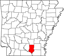 | |
| Town | ||
| Unincorporated communities | ||