Hirado, Nagasaki
| Hirado 平戸市 | |
|---|---|
| City | |
|
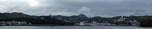
Central Area of Hirado | |
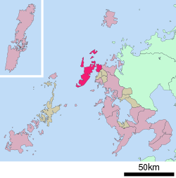 Location of Hirado in Nagasaki Prefecture | |
 Hirado Location in Japan | |
| Coordinates: 33°22′N 129°33′E / 33.367°N 129.550°ECoordinates: 33°22′N 129°33′E / 33.367°N 129.550°E | |
| Country | Japan |
| Region | Kyushu |
| Prefecture | Nagasaki Prefecture |
| Government | |
| • Mayor | Naruhiko Kuroda (since October 2009) |
| Area | |
| • Total | 235.63 km2 (90.98 sq mi) |
| Population (January 1, 2009) | |
| • Total | 36,000 |
| • Density | 153/km2 (400/sq mi) |
| Symbols | |
| • Tree | Podocarpaceae |
| • Flower | Hirado Rhododendron |
| Time zone | Japan Standard Time (UTC+9) |
| City hall address |
1508-3 Iwanoue, Hirado-shi, Nagasaki-ken 859-5192 |
| Website |
www |
Hirado (平戸市 Hirado-shi) is a city located in Nagasaki Prefecture, Japan. The part historically named Hirado is located on the island of the same name. With recent mergers, the city's boundaries have expanded, and Hirado now occupies parts of the main island of Kyushu. The components are connected by the Hirado Bridge.
As of January 1, 2009, the city has an estimated population of 36,000 and a population density of 153 persons per km². The total area is 235.63 km2 (91 square miles).
History
Hirado has been a port of call for ships between the Asian mainland and Japan since the Nara period. During the Kamakura and Muromachi periods, the local Matsuura clan held the rights to trade with Korea and with Song dynasty China. During the Sengoku and early Edo periods, Hirado's role as a center of foreign trade increased, especially vis-a-vis Ming Dynasty China and the Dutch East India Company (Vereenigde Oost-Indische Compagnie or VOC). The Portuguese arrived in 1550; and the English and Dutch initially reached Japan at the beginning of the 17th century.
The first step in the profitable Dutch-Japanese trading relationship was the Shogun's grant of a trading pass (handelspas) in 1609.[1]
At its maximum extent, the Dutch trading center covered the whole area of present-day Sakikata Park.[2] In 1637 and in 1639, stone warehouses were constructed, and the Dutch builders incorporated these dates into the stonework. However, the Tokugawa shogunate disapproved of the use of any Christian Era year dates, and therefore demanded the immediate destruction of these two structures.[3] This failure to comply with strict sakoku practices was then used as one of the Shogunate's rationales for forcing the Dutch traders to abandon Hirado for the more constricting confines of Dejima, a small artificial island in the present-day city of Nagasaki.[3] The last VOC Opperhoofd or Kapitan at Hirado and the first one at Dejima was François Caron, who oversaw the transfer in 1641.[4][5] However, modern research indicated that this incident might actually have been an excuse for the Shogunate to take the Dutch trade away from the Hirado clan.[3] The stone warehouse from 1639 that was torn down has been reconstructed in its original form in 2011.[6]
During the Edo period, Hirado was the seat of the Hirado Domain. Hirado Castle is today an historical and architectural landmark.
The island was the namesake of IJN cruiser Hirado.
The modern city was founded on January 1, 1955. The city expanded by merging on October 1, 2005, with the neighboring towns of Tabira, Ikitsuki, and the village of Ōshima. The local economy is dominated by agriculture, fishing and food processing.
Climate
Hirado has a humid subtropical climate (Köppen climate classification Cfa) with very warm summers and cool winters. Precipitation is significant throughout the year, but is much higher in the summer.
| Climate data for Hirado, Nagasaki | |||||||||||||
|---|---|---|---|---|---|---|---|---|---|---|---|---|---|
| Month | Jan | Feb | Mar | Apr | May | Jun | Jul | Aug | Sep | Oct | Nov | Dec | Year |
| Average high °C (°F) | 8.7 (47.7) |
9.2 (48.6) |
12.4 (54.3) |
17.0 (62.6) |
20.9 (69.6) |
23.6 (74.5) |
27.5 (81.5) |
29.1 (84.4) |
26.0 (78.8) |
21.4 (70.5) |
16.5 (61.7) |
11.4 (52.5) |
18.64 (65.56) |
| Daily mean °C (°F) | 6.2 (43.2) |
6.6 (43.9) |
9.3 (48.7) |
13.7 (56.7) |
17.5 (63.5) |
20.7 (69.3) |
24.9 (76.8) |
26.2 (79.2) |
23.2 (73.8) |
18.5 (65.3) |
13.6 (56.5) |
8.7 (47.7) |
15.76 (60.38) |
| Average low °C (°F) | 3.6 (38.5) |
3.9 (39) |
6.3 (43.3) |
10.8 (51.4) |
14.7 (58.5) |
18.5 (65.3) |
22.9 (73.2) |
23.9 (75) |
20.8 (69.4) |
15.7 (60.3) |
10.7 (51.3) |
6.1 (43) |
13.16 (55.68) |
| Average precipitation mm (inches) | 90.2 (3.551) |
93.6 (3.685) |
137.7 (5.421) |
207.0 (8.15) |
197.8 (7.787) |
315.5 (12.421) |
329.8 (12.984) |
204.5 (8.051) |
205.6 (8.094) |
107.5 (4.232) |
117.8 (4.638) |
72.8 (2.866) |
2,079.8 (81.88) |
| Average snowfall cm (inches) | 3 (1.2) |
2 (0.8) |
0 (0) |
0 (0) |
0 (0) |
0 (0) |
0 (0) |
0 (0) |
0 (0) |
0 (0) |
0 (0) |
1 (0.4) |
6 (2.4) |
| Average relative humidity (%) | 64 | 66 | 68 | 76 | 79 | 86 | 88 | 84 | 79 | 70 | 67 | 65 | 74.3 |
| Mean monthly sunshine hours | 88.3 | 100.0 | 156.2 | 160.9 | 181.5 | 137.5 | 157.0 | 211.1 | 166.0 | 173.6 | 131.3 | 95.7 | 1,759.1 |
| Source: NOAA (1961-1990)[7] | |||||||||||||
Notable residents
- William Adams (1564–1620): Miura Anjin (三浦按針: "the pilot of Miura"), an English navigator, was the model for the character of John Blackthorne in James Clavell's novel Shōgun (1975). Died in Hirado.
- Camillus Costanzo (1571–1622): Italian Jesuit martyr. Burnt alive in Hirado.[8]
- Koxinga (1624–1662): Taiwanese national hero and Ming general. Born in Hirado.
- Inagaki Manjiro (1861–1908): Diplomat. Born in Hirado.
International relations
Twin towns – Sister cities
Hirado has one sister city in Japan and one sister city and one friendship city outside Japan.[9]
 Zentsūji, Kagawa (Sister city)[9]
 Nan'an, Fujian, China (Friendship city)[9]
 Noordwijkerhout, Zuid-Holland (Sister city)[9]
Gallery

 Topographical map of the bay of Hirado in 1621
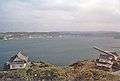 View of Hirado bay from Hirado castle, 2006
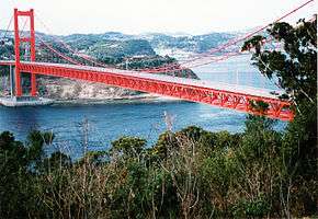 The Hirado Bridge connects the mainland city to the island. Built in 1977.
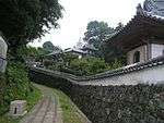 Komyo Temple (foreground), Zuiun Temple (centre), and St. Francis Xavier Catholic Church.
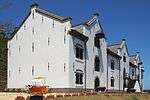 Hirado Dutch Trading Post
Notes
- ↑ "Van hier tot Tokio. 400 jaar handel met Japan," Nationaal Archief. August 28, 2009.
- ↑ Edo-Tokyo Museum exhibition catalog. (2000). A Very Unique Collection of Historical Significance: The Kapitan (the Dutch Chief) Collection from the Edo Period -- The Dutch Fascination with Japan, p.206.
- 1 2 3 Edo-Tokyo Museum exhibition catalog, p. 207.
- ↑ Caron lived in Japan from 1619 to 1641. A Collector's Guide to Books on Japan in English by Jozef Rogala, p.31
- ↑ Asia in the Making of Europe, p.459
- ↑ "Kuni shitei shiato 'hirado waran shoukan ato' fukugen kenzobutsu" Hirado Oranda Shokan
- ↑ "Hirado Climate Normals 1961-1990". National Oceanic and Atmospheric Administration. Retrieved January 6, 2013.
- ↑ Boero, Giuseppe. (1868) Les 205 martyrs du Japon, béatifiés par Pie IX en 1867, p. 249.
- 1 2 3 4 "Exchange programmes between Hirado and China, Hirado and Holland and other exchange programmes in Hirado City, Nagasaki Prefecture, Japan". City of Hirado, Nagasaki Official Website. Archived from the original on 2012-02-12. Retrieved 2013-12-17.
References
- de Winter, Michiel. (2006). "VOC in Japan: Betrekkingen tussen Hollanders en Japanners in de Edo-periode, tussen 1602-1795" ("VOC in Japan: Relations between the Dutch and Japanese in the Edo-period, between 1602-1795"). (Dutch)
- Edo-Tokyo Museum exhibition catalog. (2000). A Very Unique Collection of Historical Significance: The Kapitan (the Dutch Chief) Collection from the Edo Period—The Dutch Fascination with Japan. Catalog of "400th Anniversary Exhibition Regarding Relations between Japan and the Netherlands", a joint-project of the Edo-Tokyo Museum, the City of Nagasaki, the National Museum of Ethnology, the National Natuurhistorisch Museum" and the National Herbarium of the Netherlands in Leiden, the Netherlands. Tokyo.
- Satow, Ernest Mason, ed. (1900). The Voyage of Captain John Saris to Japan, 1613. London: Hakluyt Society...Link to digitized version from the collection of the University of California
External links
| Wikimedia Commons has media related to Hirado, Nagasaki. |
- Hirado City official website (Japanese)
- Hirado City official website (English)
- The Dutch Trading Post in Hirado
| Core cities | |||||||
|---|---|---|---|---|---|---|---|
| Cities |
| ||||||
| Higashisonogi District | |||||||
| Kitamatsuura District | |||||||
| Minamimatsuura District | |||||||
| Nishisonogi District | |||||||