Hmuifang
| Hmuifang | |
|---|---|
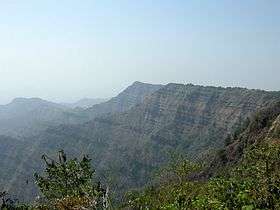 Hmuifang Mountainside | |
| Highest point | |
| Elevation | 1,619 m (5,312 ft) |
| Prominence | 1,619 m (5,312 ft) |
| Geography | |
| Location | Aizawl District, Mizoram, India |
| Parent range | Lushai Hills |
Hmuifang is a tourist spot near Aizawl, Mizoram. It is about 50 km from Aizawl With an elevation of 1619 metres, the mountain is still covered with virgin forests reserved since the Mizo Chief's time.[1] Hmuifang is on the way to Lunglei.
History
Hmuifang Tourist resort has been built right on the former land of Lallianvunga the erstwhile chief who used to rule over the villages in the mountain.[2] Hmuifang is also the source of Tuirial River.
Thalfavang Kut
Thalfavang Kut, a Mizo festival is being regularly being held in Hmuifang organized the Tourism Department of Mizoram to promote Tourism.[3] Different Mizo dances like Cheraw, Sawlakai, Siktuithiang lam and Chheihlam[4] are showcased in the festival.[5]
References
- ↑ "HMUIFANG TOURIST RESORT". Govt of Mizoram. Retrieved 24 August 2012.
- ↑ Patawrawt. "Hmuifang tlang ah lawn ru". misual.com. Retrieved 24 August 2012.
- ↑ "V Purushothaman Keen to Build Mizoram Tourist Destination". Northeast Today. Retrieved 24 August 2012.
- ↑ "Thalfavang Kut hawn a ni". Ralvengtu. Retrieved 24 August 2012.
- ↑ "GOVERNOR IN THALFAVANG KUT A HMANPUI". DIPR Mizoram. Retrieved 24 August 2012.
External links
| State symbols | |
|---|---|
| Government | |
| Topics | |
| Districts | |
| Urban Areas | |
| Infrastructure | |
| Education |
|
| Tourism | |
| Protected areas | |
This article is issued from Wikipedia - version of the 7/17/2016. The text is available under the Creative Commons Attribution/Share Alike but additional terms may apply for the media files.