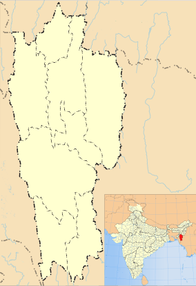
Champhai
| Champhai | |
|---|---|
| Town | |
|
Champhai town | |
 Champhai  Champhai | |
| Coordinates: 23°27′22″N 93°19′44″E / 23.456°N 93.329°ECoordinates: 23°27′22″N 93°19′44″E / 23.456°N 93.329°E | |
| Country | India |
| State | Mizoram |
| District | Champhai |
| Area | |
| • Total | 3,185.3 km2 (1,229.9 sq mi) |
| Elevation | 1,678 m (5,505 ft) |
| Population (2011) | |
| • Total | 32,734 |
| • Density | 10/km2 (27/sq mi) |
| Languages | |
| • Official | Mizo |
| Time zone | IST (UTC+5:30) |
| PIN | 796321 |
| Telephone code | 03831 |
| Vehicle registration | MZ-04 |
| Website |
champhai |
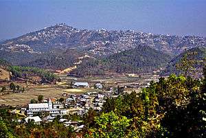
Champhai (Pron:/tʃamˈpʰaɪ/) is a border town in Mizoram state, in far eastern India. It is the headquarters of Champhai district, one of the eight districts in the state. It is located on the Indo-Myanmar border and is situated in a strategically important location. Because of this, it is the main business corridor for India and Myanmar in the area.
The area of Champhai is 3,185.83 square kilometres (1,230 sq mi). The average annual rainfall is 1,814 millimetres (71.4 in).
History
Champhai was the headquarters of Lalbura Sailo, a Mizo Chief against whom the British Expedition of 1871–72 was directed. It was accorded the status of a fort during the British period.[1]
Economy
The economy of Champhai is mainly agriculture and border trade. Champhai is also the main trading centre of Mizoram with goods like clothes, silverware and electronics imported from Myanmar[2] through the trading post in Zokhawthar.[3]It has a flatland measuring 113 kilometres long and 48 kilometres in width for wet rice cultivation which can produce 19,200 quintals of rice per year. 10,000 quintals of grape were cultivated in 2011 alone churning 20,000 bottles a year. These are the two main agricultural products.
Climate
Champhai has a moderate climate. In winter the temperature varies from 10 °C to 20 °C and in summer, and between 15 °C and 30 °C in winter.
Education
Champhai College is the only higher centre of education in the town.Many government owned and private own school are there.
Tourism
Champhai is located in a very beautiful setting, with hills on all sides and a thriving culture. Some of the more interesting places you can visit during your trip to Champhai are:
- Murlen National Park is home to a rich variety of flora and fauna. About 15 species of mammals, 150 species of birds, 35 species of medicinal plants. 2 species of bamboos & 4 species of orchids so far have been recorded in this park.
- Mura Puk is situated in Zote village, which is 10 km away from Champhai town. There are six caves at this site and these were the hiding place of the local villagers.
- Rih dïl 27 Kilometers from Champhai near Zokhawthar in Myanmar is considered to be the passage of the souls to the eternal abode. The lake is around a kilometre long and 70 metres wide.
- Thasiama Seno Neihna is a plateau on a rugged hillock measuring around 7.20 sq min near Vaphai village, which is 86 km away from Champhai.
- Fiara Tui is located about 65 km from Champhai and has its source in the Tan Tlang Mountain.
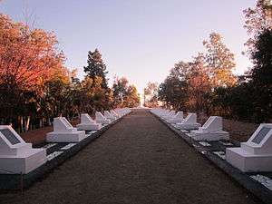
- Mizo Hlakungpui Mual - is a monument commemorating the Mizo classical composers.[4] It was set up in 1986.[5] It is located at the southern edge of Khawbung village which is near Champhai.
- Lamsial Puk is located very close to Farkawn village in the district of Champhai of the Mizoram state. It is believed that a huge fight took place at this site between two villages, during which a large number of villagers were killed.
- Hnahlan is a grape growing area which is very close to Champhai with vineyards and beautiful climate.
- Zokhawthar is a trading town 28 km from Champhai on the border with Myanmar.
- Lianchhiari Tlang about 56 km from Champhai is a rocky ledge over a high cliff near the village of Dungtlang.
- Tan Tlang is around 85 km from Champhai, it is 6356 ft above sea level located near Vaphai village
- " Lalruanga Lung" is located in N. Khawbung village, about 3 km from N.Khawbung( N.Khawbung is around 16 km from champhai). Lalruanga's history is one of the most interesting and famous in Mizo Folktales. On this Rock (Lalruanga lung), legendary Lalruangas' met his fateful end.
Media
The Major Media in Champhai are:[6]
- Lenrual
- Pasaltha
- Rihlipui
- CCN (Cable TV Operator)
- LCN (Cable TV Operator)
Transport
A helicopter service by Pawan Hans[7] has been started which connects the Aizawl with Champhai.[8] The distance between Champhai and Aizawl is 194 km and is connected with regular service of bus and sumo.[9]
References
- ↑ K. C. Kabra (2008). Economic Growth of Mizoram: Role of Business & Industry. Concept Publishing Company.
- ↑ "TRADE AND COMMERCE". CIC. Retrieved 29 August 2012.
- ↑ "Miz poised for border trade boom". The Sangai Express. Retrieved 29 August 2012.
- ↑ "Mizoram Tourism". Hlakungpui Mual (Poets’ Square). tourismmizoram.com. Retrieved 22 January 2012.
- ↑ Hlakungpui website Retrieved 21 January 2012
- ↑ "Accredited Journalists". DIPR Mizoram. Retrieved 5 September 2012.
- ↑ "MIZORAMA HELICOPTER SERVICE TUR CHIEF MINISTER IN HAWNG". Mizoram DIPR. Retrieved 14 August 2012.
- ↑ "Nilaini atangin 'Helicopter Service". The Zozam Times. Retrieved 20 August 2012.
- ↑ "Aizawl to Champhai". Mizoram NIC. Retrieved 29 August 2012.
External links
| Wikivoyage has a travel guide for Champhai. |
- Champhai.nic.in : The first official district site of Champhai town
- Champhai Blog
- Champhai.net : Champhai Daily News
| State symbols | |
|---|---|
| Government | |
| Topics | |
| Districts | |
| Urban Areas | |
| Infrastructure | |
| Education |
|
| Tourism | |
| Protected areas | |