Hol
| Hol kommune | |||
|---|---|---|---|
| Municipality | |||
| |||
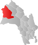 Hol within Buskerud | |||
| Coordinates: 60°34′18″N 8°4′18″E / 60.57167°N 8.07167°ECoordinates: 60°34′18″N 8°4′18″E / 60.57167°N 8.07167°E | |||
| Country | Norway | ||
| County | Buskerud | ||
| District | Hallingdal | ||
| Administrative centre | Hol | ||
| Government | |||
| • Mayor (2003) | Erik Kaupang (Ap) | ||
| Area | |||
| • Total | 1,858 km2 (717 sq mi) | ||
| • Land | 1,664 km2 (642 sq mi) | ||
| Area rank | 36 in Norway | ||
| Population (2004) | |||
| • Total | 4,556 | ||
| • Rank | 211 in Norway | ||
| • Density | 3/km2 (8/sq mi) | ||
| • Change (10 years) | -1.5 % | ||
| Demonym(s) | Holing[1] | ||
| Time zone | CET (UTC+1) | ||
| • Summer (DST) | CEST (UTC+2) | ||
| ISO 3166 code | NO-0620 | ||
| Official language form | Neutral | ||
| Website |
www | ||
|
| |||


Hol is a municipality in Buskerud county, Norway.
Administrative history
The area of Hol was separated from the municipality of Ål in 1877 to become a separate municipality. In 1937 a part of neighboring Uvdal with 220 inhabitants was moved to Hol municipality. The area of Dagali was transferred from Uvdal to Hol in 1944. In 1962 Uvdal was reunited with Nore to form the new municipality of Nore og Uvdal.
General information
Name
The municipality (originally the parish) is named after the old Hol farm (Old Norse: Hóll), since the first church was built here. The name is identical with the word hóll, which means "round (and isolated) hill".
Villages in Hol
Geography
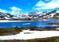
Hol is bordered to the north by Lærdal, to the north and east by Ål, to the south by Nore og Uvdal, and to the west by Eidfjord, Ulvik and Aurland. Hol is a mountainous area, where over 90% of the area is at an altitude exceeding 900 meters above sea level. The Hallingskarvet mountain range is the highest point in the municipality, at 1933 meters above sea level. The Usta or Usteåne River flows northeast from Lake Ustevatn traveling down the Ustedalen valley. The Hallingdalselva River is formed by the confluence of the Usta River and the Holselva River from Lake Strandavatnet.
Lakes
- Ustevatn - in the municipality of Hol
- Nygardsvatnet - in the municipality of Hol
- Strandavatnet - in the municipality of Hol
- Ørteren - in the municipality of Hol
- Nyhellervatnet - on the border between Hol and Aurland, Sogn og Fjordane county
- Pålsbufjorden - in the municipalities of Hol and Nore og Uvdal
- Øvre Hein - in the municipalities of Hol and Nore og Uvdal
- Djupsvatnet - in the municipalities of Hol and Ål
- Flakavatnet - in the municipalities of Hol and Ulvik, Hordaland county
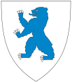
Coat-of-arms
The coat-of-arms of Hol is from modern times; the arms were granted on 5 July 1991. They show three silver anvils on a blue background and were designed by Trond Andersson. The three anvils are stacked one above the other, with the top one being largest and the bottom one smallest. The anvil was chosen to symbolize the former smithies in the municipality, which were famous for the production of axes, blades, and knives. Iron mining was already practiced in the area in the Viking Age.[2][3]
Gallery
 Lake Geiteryggen
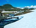 Rossdøla River
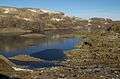 Lake Flakavatn
 Geilo
Geilo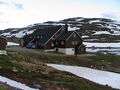 Geiteryggen
(See also coat-of-arms of Trøgstad)

Hol Old Church
Hol Old Church (Hol gamle kirke) is presumed to date from the 13th century, but the exact dating is unknown. The church is the oldest parish in Hol and is first mentioned in a letter from 1328 as a small stave church with covered side porches (svalganger). The church has been expanded several times, in the 16th century, in 1697 and in 1798-99. It was rebuilt in 1888 and 1938. It is believed that the floor of the church was made using columns from the old stave church. The pulpit and baptismal font are from the Renaissance period (1697) and the altarpiece from 1703. The pulpit is placed above the altar. [4]
Notable residents
- Ådne Søndrål, former speed skater and Olympic champion
- Håvard Bøkko, speed skater
- Christoffer Fagerli Rukke, speed skater
- Hege Bøkko, speed skater
- Martin Hole, former cross country runner
- Knut Bry, photographer
- Roger Kleivdal, snowboarder
- Joachim Havikhagen, snowboarder
- Terje Isungset, musician
Attractions
- Hallingskarvet National Park - national park in the municipalities of Hol (Buskerud), Ulvik (Hordaland) and Aurland (Sogn og Fjordane)
- Hol Bygdemuseum - located along the road from Ål to Geilo in the small village of Hagafoss. The museum is built as an old farm (holingsgard) with buildings of the local type. There are a total of 17 buildings, of which two, Nestegardsstugu and Raunsgardsstugu, have decorative wall paintings on the walls.
- Dagali Museum - museum with 10 buildings located in the middle of Dagali, on the edge of Hardangervidda. Buildings came from Dagali, Skurdalen, Tunhovd, and Uvdal; the oldest dates to the 18th century.
- Dagali Skisenter - alpine resort in Dagali, also offering sled-racing, with one of Norway's longest sled-racing hills.
- Dr Holms Hotel - resort hotel in the ski resort town of Geilo
Sister cities
The following cities are twinned with Hol:[5]
-
 - Halinga Parish, Pärnu County, Estonia
 -
 - Mäntyharju, Itä-Suomi, Finland
 -
 - Säffle, Värmland County, Sweden
See also
References
- ↑ "Navn på steder og personer: Innbyggjarnamn" (in Norwegian). Språkrådet. Retrieved 2015-12-01.
- ↑ Norske Kommunevåpen (1990). "Nye kommunevåbener i Norden". Retrieved 2009-01-07.
- ↑ "Kommunevåpenet" (in Norwegian). Hol kommune. Retrieved 2009-01-07.
- ↑ Sigrid Marie Christie, Håkon Christie. "Hol gamle kirke". Norges Kirker. Retrieved September 15, 2016.
- ↑ "Vennskapskommuner" (Microsoft Word) (in Norwegian). Hol kommune. Retrieved 2009-01-07.
External links
| Wikimedia Commons has media related to Hol. |
| Wikimedia Commons has media related to Hol old church. |
| Look up Hol in Wiktionary, the free dictionary. |
- Municipal fact sheet from Statistics Norway
 Buskerud travel guide from Wikivoyage
- Dagali Opplevelser - offering a great deal of activities in and around Dagali (Norwegian)
- Dagali Skisenter - The alpine resort in Dagali (Norwegian)
- Map hiking and DNT cabins