Ringerike (traditional district)
| Ringerike | |
|---|---|
| District | |
|
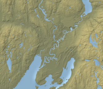
View of Tyrifjorden, a lake in southern Ringerike. | |
| Country | Norway |
| County | Buskerud |
| Region | Austlandet |
| Adm. Center | Hønefoss |
| Area | |
| • Total | 3,801 km2 (1,468 sq mi) |
| Population (2015) | |
| • Total | 55,883 |
| • Density | 15/km2 (38/sq mi) |
| Demonym(s) | Ringeriking |

Ringerike is a traditional district in Norway, commonly consisting of the municipalities Hole, and Ringerike in Buskerud county. In older times, Ringerike had a larger range which went westward, to the municipalities Krødsherad, Modum, and Sigdal, also in Buskerud.
Ringerike has a rich history that is connected with one of the most notable kings in the history of Norway, as Halfdan the Black and the Dagling clan. There are also many archaeological remains in the area, dating to the medieval period and earlier.
Etymology
The district was known in Old Norse as Hringaríki which means the reich of the Rings, and the Rings were a Germanic tribe.[1] The initial H was dropped sometime in the 13th century.[2] The etymology of the district has been, however, contested among philologists.
Halvdan Koht suggested in 1921 that the first settlers of Ringerike settled around Tyrifjorden in a ring, though this theory is outdated to many.[2]
It is suggested that Ringerike was named in a similar fashion of Romerike, which was named after the old name for Glomma, Rauma.[2] Eivind Vågslid suggested in 1959 that Ringa was the old name of the river Storelva, because it goes in a ring-shaped form.[3]
History
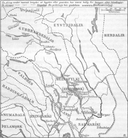
Traditionally, Ringerike referred to the area around the northern and northwestern part of Tyrifjord[2] and the lowlands along the rivers Randselva, Ådalselva and Sokna,[4] i.e. the municipalities Hole, Krødsherad, Modum, Ringerike and Sigdal in Buskerud county.[5]
Today, it may refer to the municipality Ringerike, or the municipalities Hole and Ringerike in Buskerud, which form the administrative district of Ringerike.[4] Including Jevnaker in Oppland, it forms the Council for the Ringerike Region (Rådet for Ringeriksregionen),[6] and the district court of Ringerike.[4]
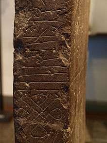
Ringerike style, a historic Scandinavian animal style, was first discovered on rune stones in Ringerike. One of these, was the Alstad stone, a rune stone found in 1913 on the farm Nedre Alstad in Østre Toten. Both Ulvøya and Ringerike are mentioned in the text.[2][7][8]
Jórunnr reisti stein þenna eptir 〈au-aun-〉er hana [á]tti,
ok fœrði af Hringaríki útan ór Ulfeyj[u].
Ok myndasteinn [mæt]ir þessi.
English translation:
Jórunnr raised this stone in memory of
who owned her (i.e. was her husband),
and (she) brought (it) out of Hringaríki,
from Ulfey.
And the picture-stone venerates them.
The Dynna stone, a rune stone from Hadeland, is of the same type of red sandstone typical for Ringerike.[9][10]
Kings of Ringerike
Ringerike was founded by its eponymous ruler Hring, who was the son of Raum the Old.[11] One of the more significant historic people who have lived in Ringerike, was the king Halfdan the Black, father of Harald Fairhair, who united Norway into a single kingdom. In the early Viking Era before Harald Fairhair became the first king of Norway, Ringerike was a petty kingdom. Dagling was a legendary clan of Ringerike.
In the Ynglinga saga, Snorri Sturluson writes that the clan was descended from Dag the Great whose daughter Dageid married the Swedish king Alaric and was the mother of Yngvi and Alf, both legendary Swedish kings of the House of Yngling. One of the sons of Dag the Great was Óli, who was the father of Dag, Óleif, Hring (the old king Ring of Frithiof's Saga), Olaf, Helgi, and Sigurd Hjört,[11] who was a petty king of Ringerike.
Sigurd Hjört was the father of Ragnhild Sigurdsdotter, the mother of Harald Fairhair. Following Harald's consolidation of Norway in the late 9th century, the kingdom appears to have been ruled by a series of local jarls and client kings. A later sub-king of Ringerike, Sigurd Syr, was the father of Harald Hardråde and the step father of Olav den hellige, both kings of Norway. When King Olaf Tryggvason came to Ringerike to spread Christianity, Sigurd Syr and his wife allowed themselves to be baptized.[12]
Administrative history
Ringerike was in its beginnings, the southwesternmost district of the historical Uplands.[5] In c. 1320, it was together with Hadeland, Land and Toten, a part of the county (or syssel) Haðafylki.[5][13] Ringerike was in c. 1640 grouped with Hallingdal in the district Buskerud og Hallingdal Fogderi.[14] In 1866, the district was divided into the Buskerud district, which included Krødsherad, Modum, and Sigdal, along with Lower Buskerud, excluding Kongsberg.[15] The rest of Ringerike, remained the same as it commonly is today.[15]
Municipalities
| Nr | Kart | Name | Adm.center | Areal km² |
Language |
|---|---|---|---|---|---|
| 0605 | |
Hønefoss | 1,555.10 | Bokmål | |
| 0612 | |
Vik | 194.80 | Bokmål | |
| 0621 | |
Prestfoss | 842.15 | Bokmål | |
| 0622 | |
Noresund | 374.63 | Neutral | |
| 0623 | |
Vikersund | 515.09 | Bokmål |
References
- ↑ Thorsnæs, Geir. "Ringerike – kommune: Navn og kommunevåpen". Retrieved 13 July 2015.
- 1 2 3 4 5 "Heftet Ringerike" (PDF). 2006. pp. 38–41. Archived from the original (PDF) on 11 August 2015.
- ↑ Norsk Allkunnebok 1959, p. 649.
- 1 2 3 "Ringerike – område". Retrieved 13 July 2015.
- 1 2 3 Munch 1849, p. 7.
- ↑ "Ringeriksregionen". ringerike.no. Archived from the original on 8 July 2014. Retrieved 13 July 2015.
- ↑ "Alstadsteinen". snl.no. Retrieved 13 July 2015.
- ↑ "N 61". abdn.ac.uk/skaldic/. Retrieved 14 August 2015.
- ↑ Solberg, Bergljot. "Dynnasteinen". snl.no. Retrieved 13 July 2015.
- ↑ Bryhni, Inge. "Ringerikssandstein". snl.no. Retrieved 13 July 2015.
- 1 2 Hversu Noregr byggðist 1394, ch. 1-2.
- ↑ Heimskringla: King Olaf Trygvason's Saga, Part II, "Section 24, Olaf Haraldson Baptized"
- ↑ Norsk Historisk Atlas 1980, map 59.
- ↑ Norsk Historisk Atlas 1980, map 71.
- 1 2 Norsk Historisk Atlas 1980, map 109.
Literature
- Munch, Peter Andreas (1849). Historisk-geographisk beskrivelse over kongeriget Norge (Noregsveldi) i middelalderen. W. Gram.
- "Ringerike". Norsk Allkunnebok. 9. Oslo: Fonna. 1959. Retrieved 13 July 2015.
- Frá Fornjóti ok hans ættmönnum: Hversu Noregr byggðist. 1394.
- Norsk Historisk Atlas. Oslo: Cappelen. 1980. ISBN 8202045347.