Sigdal
| Sigdal kommune | |||
|---|---|---|---|
| Municipality | |||
 | |||
| |||
 Sigdal within Buskerud | |||
| Coordinates: 60°3′9″N 9°36′4″E / 60.05250°N 9.60111°ECoordinates: 60°3′9″N 9°36′4″E / 60.05250°N 9.60111°E | |||
| Country | Norway | ||
| County | Buskerud | ||
| District | Ringerike | ||
| Administrative centre | Prestfoss | ||
| Government | |||
| • Mayor (2007) | Kari Kolbræk Ask (Sp) | ||
| Area | |||
| • Total | 842 km2 (325 sq mi) | ||
| • Land | 811 km2 (313 sq mi) | ||
| Area rank | 130 in Norway | ||
| Population (2004) | |||
| • Total | 3,530 | ||
| • Rank | 244 in Norway | ||
| • Density | 4/km2 (10/sq mi) | ||
| • Change (10 years) | -3.9 % | ||
| Demonym(s) | Sigdøl or Sigdøling[1] | ||
| Time zone | CET (UTC+1) | ||
| • Summer (DST) | CEST (UTC+2) | ||
| ISO 3166 code | NO-0621 | ||
| Official language form | Bokmål | ||
| Website |
www | ||
|
| |||

Sigdal is a municipality in Buskerud county, Norway. The administrative centre of the municipality is the village of Prestfoss.[2]
The municipality of Sigdal was established on 1 January 1838 (see formannskapsdistrikt). The area of Krødsherad was separated from Sigdal on 1 January 1901. The municipality has common borders with the municipalities of Flå, Krødsherad, Modum, Øvre Eiker, Flesberg, Rollag, and Nore og Uvdal.
Name
The Old Norse form of the name was Sigmardalr or Sigmudalr. The first element is the genitive case of a river name Sigm(a) (now called the Simoa) and the last element is dalr which means "valley" or "dale". The Simoa river runs through Sigdal, flowing in a south-easterly course until it flows into Drammenselva at Åmot in Modum. The meaning of the river name is unknown, but is maybe derived from síga which means to "ooze" or "slide".
Coat-of-arms
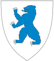
The coat-of-arms is from modern times. They were granted on 18 November 1983. The arms show a heraldic image of the mountain that dominates the view around the village, the Andersnatten. The profile of the mountain is yellow with a blue-colored sky above.[3]
Geography and population
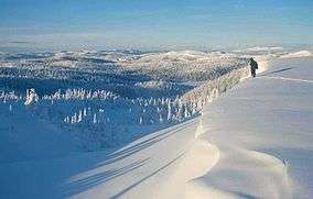
Most of the citizens live in the village of Eggedal or the administrative centre of Prestfoss. Sigdal is densely populated, dominated by mountains and valleys.
About 72% of the area is covered with forest, 20% is mountain areas, and 4% of the area is cultivated. Agriculture, forestry, and the kitchen-producing enterprise of Sigdal Kjøkken are still important industries.

Local Attractions
- Folk Music Center (Folkemusikksenteret) is a cultural heritage museum offering a good image of the building style and traditions of the district. The Folk Music Center is principally responsible for collecting, storing and promoting local folk music and dance.
- Sigdal-Eggedal Museum is a regional museum for Krødsherad, Modum and Sigdal. This museum dedicated to the region's culture and history is arranged particularly authentically.
- Holmen Church in Sigdal dates to 1855.
- Lauvlia is the former home of Theodor Kittelsen, one of the most popular artists in Norway, who settled near Prestfoss during 1899. Today Lauvlia is a private museum featuring an exhibition of Kittelsen’s original work
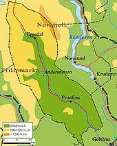
- Andersnatten is a well-known mountain and landmark. The mountain has inspired painters visiting or living in Sigdal, notably Theodor Kittelsen and Christian Skredsvig. It is recognized by mountain climbers as a tough challenge.
Protected areas in Sigdal Municipality
- Heimseteråsen nature reserve, established on 13 December 2002, 2,515 acres
- Solevatn nature reserve, established 20 June 1986, 538 acres
- Trillemarka nature reserve, established on 13 December 2002, 43,285 acres
Notable residents
- Dag Aabye (born 1941) "Father of Freeride Skiing"
- Gulbrand Hagen (1864 - 1919) Norwegian-American newspaper editor and writer
- Theodor Kittelsen (1857 - 1914) Norwegian artist and painter
- Olaf Knudson (1915 – 1996), politician for the Norwegian Conservative Party
- Erik Ramstad (1860 - 1951) Norwegian-American founder of Minot, North Dakota
- Christian Skredsvig (1854 - 1924) Norwegian artist and painter
- Olaf Solumsmoen (1896 - 1972) Newspaper editor and politician for the Norwegian Labour Party.
Sister cities
The following cities are twinned with Sigdal:
-
 Äänekoski, Central Finland, Finland
 -
 Hveragerði, Iceland[4]
 -
 Örnsköldsvik, Västernorrland County, Sweden[5]
See also
References
- ↑ "Navn på steder og personer: Innbyggjarnamn" (in Norwegian). Språkrådet. Retrieved 2015-12-01.
- ↑ Sigdal (Store norske leksikon)
- ↑ Norske Kommunevåpen (1990). "Nye kommunevåbener i Norden". Retrieved 2009-01-10.
- ↑ "Norrænt samstarf" (in Icelandic). Hveragerði. Retrieved 2009-01-10.
- ↑ "Vänorter" (in Swedish). Örnsköldsvik kommun. Retrieved 2009-01-10.
Other sources
- Mørch, Andreas & Thormod Skatvedt Sigdal og Eggedal (Sigdal og Eggedal, 1914)
- Mørch, Andreas Frå gamle dagar. Folkeminne frå Sigdal og Eggedal (Norsk Folkeminnelag: 1932)
External links
| Wikimedia Commons has media related to Sigdal. |
| Look up Sigdal in Wiktionary, the free dictionary. |
- Municipal fact sheet from Statistics Norway
 Buskerud travel guide from Wikivoyage
- Kunstnerdalen, Valley of Artists
- Sigdal & Eggedal Tourist Service
- Sigdalslag
- Sigdal Kommune official webpage (Norwegian)
- Krødsherad, Sigdal and Modum (Norwegian)
- Information and news from Sigdal and Eggedal (Norwegian)