Rollag
| Rollag kommune | |||
|---|---|---|---|
| Municipality | |||
| |||
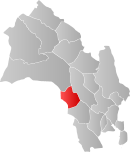 Rollag within Buskerud | |||
| Coordinates: 60°1′2″N 9°14′2″E / 60.01722°N 9.23389°ECoordinates: 60°1′2″N 9°14′2″E / 60.01722°N 9.23389°E | |||
| Country | Norway | ||
| County | Buskerud | ||
| District | Numedal | ||
| Administrative centre | Rollag | ||
| Government | |||
| • Mayor (2003) | Steinar Berthelsen (Ap) | ||
| Area | |||
| • Total | 449 km2 (173 sq mi) | ||
| • Land | 430 km2 (170 sq mi) | ||
| Area rank | 225 in Norway | ||
| Population (2004) | |||
| • Total | 1,495 | ||
| • Rank | 369 in Norway | ||
| • Density | 3/km2 (8/sq mi) | ||
| • Change (10 years) | 1.4 % | ||
| Demonym(s) | Rølling[1] | ||
| Time zone | CET (UTC+1) | ||
| • Summer (DST) | CEST (UTC+2) | ||
| ISO 3166 code | NO-0632 | ||
| Official language form | Neutral | ||
| Website |
www | ||
|
| |||

Rollag is a municipality in Buskerud county, Norway. It is part of the traditional region of Numedal. The administrative centre of the municipality is the village of Rollag, although the most populated area in the municipality is Veggli. Rollag is bordered in the north by Nore og Uvdal, in the east by Sigdal, in the south by Flesberg, and in the west by Tinn in Telemark.[2]
General information
History
The municipality (originally the parish) is named after the old Rollag farm (Old Norse: Roll(u)lag), since the first church was built here. The first element is probably (the genitive case of) a river name Rolla (now called the Troelva river) and the last element is lag which means "fishing place".[3]
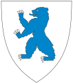
The municipality of Rollag was established on 1 January 1838 (see formannskapsdistrikt). Nore og Uvdal was separated from Rollag in 1858. The coat-of-arms is from modern times. They were granted in 1993. The arms show two gold-colored lines on a red background. The lines represent an old warning cairn made of timber.
Geography
The municipality lies in the heart of the Numedal traditional region and valley, the westernmost valley in southeastern Norway. The river Numedalslågen flows through Rollag and into the Ytre Oslofjord at Larvik. In the northwest of the Rollag lie the Vegglifjell mountains, which are an entryway into the Hardangervidda. The municipality's highest point is Storegrønut at 1,289 metres (4,229 ft) located in the Vegglifjell mountains.[4][5]
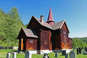
Rollag stave church
Rollag stave church (Rollag stavkirke) was built around 1150-1200. It is located a few kilometres north of the centre of Rollag. It was extended and windows were added in 1652. A new Apse was added in 1666. The transept was constructed in 1697-1698. A gallery was added in 1702. The sacristy was built in 1739. A Baroque pulpit was added in 1763.[6][7]
Sister cities
The following cities are twinned with Rollag:[8]
References
- ↑ "Navn på steder og personer: Innbyggjarnamn" (in Norwegian). Språkrådet. Retrieved 2015-12-01.
- ↑ Geir Thorsnæs. "Rollag". Store norske leksikon. Retrieved September 15, 2016.
- ↑ "Rollag. Rollag herad. Buskerud". Matrikkelutkastet av 1950. May 21, 2012. Retrieved September 15, 2016.
- ↑ Geir Thorsnæs. "Numedal". Store norske leksikon. Retrieved September 15, 2016.
- ↑ "Numedalslågen". Store norske leksikon. Retrieved September 15, 2016.
- ↑ "Rollag stavkirke". Riksantikvaren. May 21, 2012. Retrieved September 15, 2016.
- ↑ Nina Aldin Thune. "Rollag stavkirke". Store norske leksikon. Retrieved September 15, 2016.
- ↑ "Jokioinen" (in Norwegian). Rollag kommune. Retrieved 2009-01-11.
External links
| Wikimedia Commons has media related to Rollag. |
| Look up Rollag in Wiktionary, the free dictionary. |
- Municipal fact sheet from Statistics Norway
 Buskerud travel guide from Wikivoyage
- Culture in Rollag on the map from Kulturnett.no
- Another map of Rollag