Holden, West Virginia
| Holden, West Virginia | |
|---|---|
| CDP | |
|
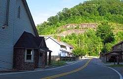
Trace Avenue in Holden | |
 Holden, West Virginia Location within the state of West Virginia | |
| Coordinates: 37°49′7″N 82°3′42″W / 37.81861°N 82.06167°WCoordinates: 37°49′7″N 82°3′42″W / 37.81861°N 82.06167°W | |
| Country | United States |
| State | West Virginia |
| County | Logan |
| Area[1] | |
| • Total | 3.7 sq mi (9.7 km2) |
| • Land | 3.7 sq mi (9.7 km2) |
| • Water | 0.0 sq mi (0.0 km2) |
| Elevation | 735 ft (224 m) |
| Population (2010)[2] | |
| • Total | 876 |
| • Density | 240/sq mi (90/km2) |
| Time zone | Eastern (EST) (UTC-5) |
| • Summer (DST) | EDT (UTC-4) |
| ZIP code | 25625 |
| Area code(s) | 304 |
| FIPS code | 54-37948[3] |
| GNIS feature ID | 1540381[4] |
Holden is a census-designated place (CDP) in Logan County, West Virginia, United States. The population was 876 at the 2010 census.[2]
Geography
Holden is located at 37°49′7″N 82°3′42″W / 37.81861°N 82.06167°W (37.818640, -82.061541),[1] along the Copperas Mine Fork.[5]
According to the United States Census Bureau, the CDP has a total area of 9.7 square miles (3.7 km²), all of it land.
Demographics
As of the census[3] of 2000, there were 1,105 people, 436 households, and 324 families residing in the CDP. The population density was 113.1 people per square mile (43.7/km²). There were 488 housing units at an average density of 49.9/sq mi (19.3/km²). The racial makeup of the CDP was 90.23% White, 8.87% African American, 0.18% Asian, 0.09% from other races, and 0.63% from two or more races. Hispanic or Latino of any race were 0.27% of the population.
There were 436 households out of which 27.5% had children under the age of 18 living with them, 53.2% were married couples living together, 17.7% had a female householder with no husband present, and 25.5% were non-families. 23.4% of all households were made up of individuals and 12.6% had someone living alone who was 65 years of age or older. The average household size was 2.51 and the average family size was 2.95.
In the CDP the population was spread out with 23.1% under the age of 18, 9.3% from 18 to 24, 26.8% from 25 to 44, 26.0% from 45 to 64, and 14.8% who were 65 years of age or older. The median age was 40 years. For every 100 females there were 85.7 males. For every 100 females age 18 and over, there were 79.3 males.
The median income for a household in the CDP was $23,510, and the median income for a family was $30,750. Males had a median income of $24,653 versus $21,316 for females. The per capita income for the CDP was $11,615. About 19.4% of families and 20.9% of the population were below the poverty line, including 30.1% of those under age 18 and 23.9% of those age 65 or over.
Notable people
- Max Butcher, baseball pitcher of the 1930s and 1940s, was born in Holden.
References
- 1 2 "US Gazetteer files: 2010, 2000, and 1990". United States Census Bureau. 2011-02-12. Retrieved 2011-04-23.
- 1 2 "American FactFinder". United States Census Bureau. Retrieved 2011-05-14.
- 1 2 "American FactFinder". United States Census Bureau. Retrieved 2008-01-31.
- ↑ "US Board on Geographic Names". United States Geological Survey. 2007-10-25. Retrieved 2008-01-31.
- ↑ West Virginia Atlas & Gazetteer. Yarmouth, Me.: DeLorme. 1997. p. 57. ISBN 0-89933-246-3.
