Holly Springs, Surry County, North Carolina
| Holly Springs | |
|---|---|
| Unincorporated community | |
 Holly Springs Location within the state of North Carolina | |
| Coordinates: 36°28′09″N 80°32′23″W / 36.46917°N 80.53972°WCoordinates: 36°28′09″N 80°32′23″W / 36.46917°N 80.53972°W | |
| Country | United States |
| State | North Carolina |
| County | Surry |
| Elevation | 1,322 ft (403 m) |
| Time zone | Eastern (EST) (UTC-5) |
| • Summer (DST) | EDT (UTC-4) |
| ZIP codes | 27030 (Mount Airy) |
| Area code(s) | 336 |
| GNIS feature ID | 2710673 |
Holly Springs is an unincorporated community located in the Mount Airy Township of Surry County, North Carolina. The community is generally centered on the intersection of Holly Springs Road and Reeves Mill Road, southeast of Bannertown. The Mount Airy/Surry County Airport is located in Holly Springs. Other prominent landmarks include Holly Springs Baptist Church and a Bannertown Volunteer Fire Department substation.
References
Municipalities and communities of Surry County, North Carolina, United States | ||
|---|---|---|
| City | 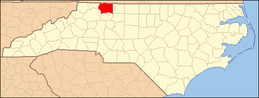 | |
| Towns | ||
| CDPs | ||
| Unincorporated communities |
| |
| Footnotes | ‡This populated place also has portions in an adjacent county or counties | |
This article is issued from Wikipedia - version of the 11/25/2014. The text is available under the Creative Commons Attribution/Share Alike but additional terms may apply for the media files.