Hortelã
| Hortelã | |
|---|---|
 | |
| Coordinates: 16°36′43″N 24°21′18″W / 16.612°N 24.355°WCoordinates: 16°36′43″N 24°21′18″W / 16.612°N 24.355°W | |
| Country | Cape Verde |
| Island | São Nicolau |
| Municipality | Tarrafal de São Nicolau |
| Civil parish | São Francisco de Assis |
| Population (2010)[1] | |
| • Total | 181 |
Hortelã is a settlement in the western part of the island of São Nicolau, Cape Verde. It is situated at the southern foot of Monte Gordo, 5 km north of Tarrafal de São Nicolau and 6 km west of Ribeira Brava.
Subdivisions
Its subdivisons are divided into five neighborhoods (bairros) including:
- Espigão
- Hostelão de Lá
- Chã de Manuel da Luz
- Galo Canto
- Alto de Nhõ Vidal
See also
References
- ↑ "2010 Census results". Instituto Nacional de Estatística Cabo Verde (in Portuguese). 17 March 2014.
The island of São Nicolau and the surrounding islands | ||
|---|---|---|
| Communities and settlements | 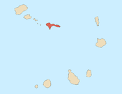 | |
| Municipalities | ||
| Parishes | ||
| Mountains | ||
| Other geographic features |
| |
This article is issued from Wikipedia - version of the 4/18/2016. The text is available under the Creative Commons Attribution/Share Alike but additional terms may apply for the media files.