Hortonville, Wisconsin
| Hortonville, Wisconsin | |
|---|---|
| Village | |
|
| |
 Location of Hortonville, Wisconsin | |
 Location of Hortonville, Wisconsin in Outagamie County | |
| Coordinates: 44°20′7″N 88°38′20″W / 44.33528°N 88.63889°WCoordinates: 44°20′7″N 88°38′20″W / 44.33528°N 88.63889°W | |
| Country | United States |
| State | Wisconsin |
| County | Outagamie |
| Area[1] | |
| • Total | 3.55 sq mi (9.19 km2) |
| • Land | 3.47 sq mi (8.99 km2) |
| • Water | 0.08 sq mi (0.21 km2) |
| Elevation[2] | 794 ft (242 m) |
| Population (2010)[3] | |
| • Total | 2,711 |
| • Estimate (2012[4]) | 2,712 |
| • Density | 781.3/sq mi (301.7/km2) |
| Time zone | Central (CST) (UTC-6) |
| • Summer (DST) | CDT (UTC-5) |
| Area code(s) | 920 |
| FIPS code | 55-35850[5] |
| GNIS feature ID | 1566752[2] |
| Website | Village Website |
Hortonville is a village in Outagamie County, Wisconsin, United States. The population was 2,711 at the 2010 census.
History
The village was founded in 1848 by landowner Alonzo Horton. One of Horton's first priorities was to dam Black Otter Creek, creating the 75-acre (300,000 m2) Black Otter Lake. After laying out a plat for the community and encouraging development by giving much of the land away, Horton was swayed westward by the California Gold Rush. He later developed the city of San Diego, California.[6]
On August 11, 1894, the settlement was incorporated as the Village of Hortonville. At that time, it had one of the first match light factories in the world.[7]
During World War II, a German POW camp was established in Hortonville along County Hwy MM on the north side of the village.[8]
In 1981, the Hortonville Community Hall, also known as the Hortonville Opera House, was added to the National Register of Historic Places.
Geography
Hortonville is located at 44°20′7″N 88°38′20″W / 44.33528°N 88.63889°W (44.335196, -88.638847).[9]
According to the United States Census Bureau, the village has a total area of 3.55 square miles (9.19 km2), of which, 3.47 square miles (8.99 km2) of it is land and 0.08 square miles (0.21 km2) is water.[1]
Black Otter Lake
The community is located on the shores of the 75-acre (300,000 m2) Black Otter Lake. It is drained by Black Otter Creek, which flows into the Wolf River just north of the village. The total watershed for the lake is estimated to be 16 square miles (41 km2).[10]
The Black Otter is the only public access lake in Outagamie County. Because of this, it receives substantial recreational use, primarily by anglers, throughout the year. Fish species in the lake include: bluegill, largemouth bass, black crappie, yellow perch, northern pike and catfish.[10]
The village maintains a public boat launch, a fishing pier and two parks along the shores of the lake. Black Otter County Park is located on the north shore of the lake and also has a public boat launch.
Demographics
| Historical population | |||
|---|---|---|---|
| Census | Pop. | %± | |
| 1880 | 311 | — | |
| 1890 | 440 | 41.5% | |
| 1900 | 913 | 107.5% | |
| 1910 | 863 | −5.5% | |
| 1920 | 960 | 11.2% | |
| 1930 | 906 | −5.6% | |
| 1940 | 968 | 6.8% | |
| 1950 | 1,081 | 11.7% | |
| 1960 | 1,366 | 26.4% | |
| 1970 | 1,524 | 11.6% | |
| 1980 | 2,016 | 32.3% | |
| 1990 | 2,029 | 0.6% | |
| 2000 | 2,357 | 16.2% | |
| 2010 | 2,711 | 15.0% | |
| Est. 2015 | 2,712 | [11] | 0.0% |
Hortonville is a part of the Appleton-Oshkosh-Neenah CSA, a Combined Statistical Area that includes the Appleton (Calumet and Outagamie counties) and Oshkosh-Neenah (Winnebago County) metropolitan areas,[13][14] which had a combined population of 358,365 at the 2000 census.[5]
2010 census
As of the census[3] of 2010, there were 2,711 people, 1,045 households, and 766 families residing in the village. The population density was 781.3 inhabitants per square mile (301.7/km2). There were 1,105 housing units at an average density of 318.4 per square mile (122.9/km2). The racial makeup of the village was 96.9% White, 0.2% African American, 0.2% Native American, 1.2% Asian, 0.4% from other races, and 1.1% from two or more races. Hispanic or Latino of any race were 1.5% of the population.
There were 1,045 households of which 38.8% had children under the age of 18 living with them, 57.1% were married couples living together, 10.6% had a female householder with no husband present, 5.6% had a male householder with no wife present, and 26.7% were non-families. 22.0% of all households were made up of individuals and 7.3% had someone living alone who was 65 years of age or older. The average household size was 2.59 and the average family size was 3.01.
The median age in the village was 36.7 years. 26.9% of residents were under the age of 18; 7.5% were between the ages of 18 and 24; 29% were from 25 to 44; 25.2% were from 45 to 64; and 11.4% were 65 years of age or older. The gender makeup of the village was 49.2% male and 50.8% female.
2000 census
At the 2000 census,[5] there were 2,357 people, 871 households and 634 families residing in the village. The population density was 868.2 per square mile (335.8/km²). There were 904 housing units at an average density of 333.0 per square mile (128.8/km²). The racial makeup of the village was 96.99% White, 0.13% African American, 0.04% Native American, 2.21% Asian, 0.17% from other races, and 0.47% from two or more races. Hispanic or Latino of any race were 0.64% of the population.
There were 871 households of which 38.9% had children under the age of 18 living with them, 60.5% were married couples living together, 9.0% had a female householder with no husband present, and 27.1% were non-families. 22.4% of all households were made up of individuals and 8.8% had someone living alone who was 65 years of age or older. The average household size was 2.70 and the average family size was 3.21.
29.7% of the population were under the age of 18, 7.6% from 18 to 24, 31.3% from 25 to 44, 20.8% from 45 to 64, and 10.6% who were 65 years of age or older. The median age was 34 years. For every 100 females there were 92.9 males. For every 100 females age 18 and over, there were 91.7 males.
The median household income was $51,635 and the median family income was $55,298. Males had a median income of $41,689 compared with $24,680 for females. The per capita income for the village was $20,277. About 4.4% of families and 6.9% of the population were below the poverty line, including 12.2% of those under age 18 and 6.0% of those age 65 or over.
Transportation
| | WIS 15, also marked Main Street, is an east-west route connecting Hortonville with the communities of Appleton, Greenville, and New London. |
| | County M, also marked Nash Street & Olk Street, is a north-south route connecting Hortonville with State Hwy 54 to the north & State Hwy 96 at Medina to the south. |
| | County T is a north-south route connecting Hortonville with New London to the northwest & State Hwy 96 at Dale to the south. |
| | County JJ is an eastbound route connecting Hortonville with the city of Kaukauna. |
| | County MM, also known as the North Crest Street, is a northeast route connecting Hortonville with State Hwy 76 at Stephensville. |
| | County TT is a westbound route connecting Hortonville with U.S. Route 45, which was rerouted west of the village in 2003. |
| | Rustic Road 61 is a 3.5-mile (5.6 km) state-designated scenic route that follows County MM from Hortonville to Stephensville. |
Outagamie County Regional Airport provides commercial airline service to the village.
Education
The Hortonville Area School District, which includes a high school, two middle schools and three elementary schools, serves the village and the surrounding communities. Bethlehem Lutheran School is a religious school for area residents.
Points of interest
- Black Otter Lake
- Eagle Creek and Grand View Golf Clubs
- Wiouwash State Trail
- Wolf River
Notable residents and natives
- Dave Gassner, professional baseball player
- David Hodgins, Wisconsin legislator
- Isaac N. McComb, Wisconsin legislator and physician
- Charlie Nagreen, inventor of the hamburger
- Gerald Nye, U.S. Senator from North Dakota
Images
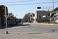 Looking east at downtown Hortonville
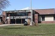
 Welcome sign
 Hortonville Community Hall, on the National Register of Historic Places
References
- 1 2 "US Gazetteer files 2010". United States Census Bureau. Archived from the original on 2012-01-24. Retrieved 2012-11-18.
- 1 2 "US Board on Geographic Names". United States Geological Survey. 2007-10-25. Retrieved 2008-01-31.
- 1 2 "American FactFinder". United States Census Bureau. Retrieved 2012-11-18.
- ↑ "Population Estimates". United States Census Bureau. Archived from the original on 2013-06-17. Retrieved 2013-06-24.
- 1 2 3 "American FactFinder". United States Census Bureau. Archived from the original on 2013-09-11. Retrieved 2008-01-31.
- ↑ About The Village of Hortonville, Wisconsin who later went on to develop San Diego
- ↑ About Hortonville
- ↑ POW camps
- ↑ "US Gazetteer files: 2010, 2000, and 1990". United States Census Bureau. 2011-02-12. Retrieved 2011-04-23.
- 1 2 http://blackotterlake.com/files/6-23-08_Update_Lake_Management_Plan.pdf
- ↑ "Annual Estimates of the Resident Population for Incorporated Places: April 1, 2010 to July 1, 2015". Retrieved July 2, 2016.
- ↑ "Census of Population and Housing". Census.gov. Archived from the original on May 11, 2015. Retrieved June 4, 2015.
- ↑ METROPOLITAN STATISTICAL AREAS AND COMPONENTS , Office of Management and Budget, 2007-05-11. Accessed 2008-08-01.
- ↑ COMBINED STATISTICAL AREAS AND COMPONENT CORE BASED STATISTICAL AREAS , Office of Management and Budget, 2007-05-11. Accessed 2008-08-01.
External links
| Wikimedia Commons has media related to Hortonville, Wisconsin. |
- Village of Hortonville
- Hortonville Chamber of Commerce
- Hortonville Public Library
- Black Otter Lake
- Eagle Creek Golf Club
- Grand View Golf Club
- Sanborn fire insurance maps: 1894 1901 1909
| Core cities |  | |
|---|---|---|
| Largest municipalities over 10,000 in 2010 | ||
| Municipalities under 10,000 in 2010 |
| |
| Counties | ||
| ||
Municipalities and communities of Outagamie County, Wisconsin, United States | ||
|---|---|---|
| Cities | 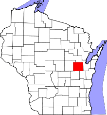 | |
| Villages | ||
| Towns | ||
| CDP | ||
| Unincorporated communities | ||
| Indian reservation | ||
| Ghost towns | ||
| Footnotes | ‡This populated place also has portions in an adjacent county or counties | |