Humboldt, Tennessee
| Humboldt, Tennessee | |
|---|---|
| City | |
 Humboldt, Tennessee Location of Humboldt, Tennessee | |
| Coordinates: 35°49′21″N 88°54′40″W / 35.82250°N 88.91111°WCoordinates: 35°49′21″N 88°54′40″W / 35.82250°N 88.91111°W | |
| Country | United States |
| State | Tennessee |
| Counties | Gibson, Madison |
| Area | |
| • Total | 9.7 sq mi (25.0 km2) |
| • Land | 9.7 sq mi (25.0 km2) |
| • Water | 0.0 sq mi (0.0 km2) |
| Elevation | 364 ft (111 m) |
| Population (2010) | |
| • Total | 8,452 |
| • Density | 870/sq mi (340/km2) |
| Time zone | Central (CST) (UTC-6) |
| • Summer (DST) | CDT (UTC-5) |
| ZIP code | 38343 |
| Area code(s) | 731 |
| FIPS code | 47-36460[1] |
| GNIS feature ID | 1288697[2] |
| Website |
www www |
Humboldt is a city in Gibson and Madison counties, Tennessee. The population was 8,452 at the 2010 census, a decline of 1,015 from 2000. It is the principal city of and is included in the Humboldt, Tennessee Micropolitan Statistical Area, which is included in the Jackson, Tennessee-Humboldt, Tennessee Combined Statistical Area. It is Gibson County's largest city.
History
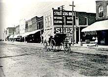
The first settlers of what would become Humboldt, began moving into the area in the mid 1850s. The town was a Railroad town. Its history begins with the Crossing of the Mobile & Ohio and the Memphis & Ohio (later L&N) Railroads. This was completed in 1859. The town wasn't chartered until after the Civil War in 1866. (Source: www.humboldthistorical.com)
The city is named for German naturalist Alexander von Humboldt.[3]
Geography
Humboldt is located at 35°49′21″N 88°54′40″W / 35.822564°N 88.911138°W (35.822564, -88.911138).[4] Most of the city lies in Gibson County, with only a small portion extending into Madison County. In the 2000 census, 9,442 of the city's 9,467 residents (99.7%) lived in Gibson County and 25 (0.3%) in Madison County.[5]
According to the United States Census Bureau, the city has a total area of 9.7 square miles (25.0 km2), of which 9.7 square miles (25.0 km2) is land and 0.10% is water.
Demographics
| Historical population | |||
|---|---|---|---|
| Census | Pop. | %± | |
| 1880 | 1,572 | — | |
| 1890 | 1,837 | 16.9% | |
| 1900 | 2,866 | 56.0% | |
| 1910 | 3,446 | 20.2% | |
| 1920 | 3,913 | 13.6% | |
| 1930 | 4,613 | 17.9% | |
| 1940 | 5,160 | 11.9% | |
| 1950 | 7,428 | 44.0% | |
| 1960 | 8,482 | 14.2% | |
| 1970 | 10,066 | 18.7% | |
| 1980 | 10,209 | 1.4% | |
| 1990 | 9,651 | −5.5% | |
| 2000 | 9,467 | −1.9% | |
| 2010 | 8,452 | −10.7% | |
| Est. 2015 | 8,313 | [6] | −1.6% |
| Sources:[7][8] | |||
As of the census[1] of 2000, there were 9,467 people, 3,864 households, and 2,538 families residing in the city. The population density was 980.0 people per square mile (378.4/km2). There were 4,243 housing units at an average density of 439.2 per square mile (169.6/km2). The racial makeup of the city was 55.06% White, 43.00% African American, 0.25% Native American, 0.06% Asian, 1.00% from other races, and 0.61% from two or more races. Hispanic or Latino of any race were 1.56% of the population.
There were 3,864 households out of which 28.5% had children under the age of 18 living with them, 41.4% were married couples living together, 20.0% had a female householder with no husband present, and 34.3% were non-families. 30.8% of all households were made up of individuals and 14.8% had someone living alone who was 65 years of age or older. The average household size was 2.36 and the average family size was 2.93.
In the city the population was spread out with 24.0% under the age of 18, 8.8% from 18 to 24, 24.7% from 25 to 44, 22.1% from 45 to 64, and 20.4% who were 65 years of age or older. The median age was 39 years. For every 100 females there were 86.4 males. For every 100 females age 18 and over, there were 80.0 males.
The median income for a household in the city was $26,351, and the median income for a family was $32,845. Males had a median income of $30,848 versus $20,890 for females. The per capita income for the city was $14,433. About 16.1% of families and 18.1% of the population were below the poverty line, including 24.8% of those under age 18 and 16.9% of those age 65 or over.
Climate
The climate in this area is characterized by relatively high temperatures and evenly distributed precipitation throughout the year. According to the Köppen Climate Classification system, Humboldt has a Humid subtropical climate, abbreviated "Cfa" on climate maps.[9]
| Climate data for Humboldt, Tennessee | |||||||||||||
|---|---|---|---|---|---|---|---|---|---|---|---|---|---|
| Month | Jan | Feb | Mar | Apr | May | Jun | Jul | Aug | Sep | Oct | Nov | Dec | Year |
| Average high °C (°F) | 10 (50) |
12 (53) |
16 (61) |
22 (72) |
27 (80) |
31 (88) |
33 (91) |
33 (91) |
29 (85) |
24 (75) |
16 (61) |
11 (52) |
22 (72) |
| Average low °C (°F) | −1 (31) |
1 (33) |
4 (39) |
9 (49) |
14 (57) |
18 (65) |
20 (68) |
19 (67) |
16 (60) |
9 (48) |
3 (38) |
1 (33) |
9 (49) |
| Average precipitation mm (inches) | 163 (6.4) |
122 (4.8) |
135 (5.3) |
114 (4.5) |
100 (4) |
107 (4.2) |
117 (4.6) |
86 (3.4) |
86 (3.4) |
66 (2.6) |
109 (4.3) |
112 (4.4) |
1,316 (51.8) |
| Source: Weatherbase[10] | |||||||||||||
Transportation
Road
U.S. Route 79 and U.S. Route 45W intersect in Humboldt. Interstate 40 is about 13 miles (21 km) away in Jackson, and Interstate 155 is about 36 miles (58 km) away in Dyersburg.
Air
The city-owned Humboldt Municipal Airport is located in Gibson County. The nearest airports with regularly scheduled commercial service are Memphis International, about 90 miles (140 km) away, and Nashville International, about 150 miles (240 km) away.
Rail
The Newbern–Dyersburg train station is about 36 miles (58 km) away in Newbern, and Memphis Central Station is about 90 miles (140 km) away.
Media
Cable
Cable TV is supplied through a locally owned business called Infostructure Inc.
Newspaper
The local newspaper is called the Humboldt Chronicle(http://hchronicle.net).
Television
W45CK Channel 45 is a Unity Broadcasting Network station.
Radio
WDVW 105.3 "The Dove" - Contemporary Christian Music. www.gracebroadcasting.com
WJPJ AM 1190
WIRJ AM 740
Special events
Since 1934, the city has hosted the West Tennessee Strawberry Festival, held the first full week of May.
Notable people
- Rayburn Anthony - Rockabilly, country and gospel musician[11]
- Doug Atkins - Football player
- Chick Autry - Baseball player
- Jesse Hill Ford - Writer & playwright
- Lew Jetton - Musician, television personality
- Wyatt Prunty - Poet
- T.G. Sheppard - Country music singer
- Dale Sommers - Radio personality
- Murray Warmath - College football coach
- Samuel Cole Williams - Historian
- Kacy Rodgers - NFL assistant football coach
- Ben E. Clement - World War I Aviator, Fluorspar Miner, Artist, Entrepreneur, Museum in Marion, KY
References
- 1 2 "American FactFinder". United States Census Bureau. Archived from the original on September 11, 2013. Retrieved 2008-01-31.
- ↑ "US Board on Geographic Names". United States Geological Survey. 2007-10-25. Retrieved 2008-01-31.
- ↑ Larry L. Miller (2001), Tennessee place-names, Indiana University Press. Page 104.
- ↑ "US Gazetteer files: 2010, 2000, and 1990". United States Census Bureau. 2011-02-12. Retrieved 2011-04-23.
- ↑ "Subcounty population estimates: Tennessee 2000-2006" (CSV). United States Census Bureau, Population Division. 2007-06-28. Retrieved 2007-10-09.
- ↑ "Annual Estimates of the Resident Population for Incorporated Places: April 1, 2010 to July 1, 2015". Retrieved July 2, 2016.
- ↑ "Census of Population and Housing: Decennial Censuses". United States Census Bureau. Retrieved 2012-03-04.
- ↑ "Incorporated Places and Minor Civil Divisions Datasets: Subcounty Resident Population Estimates: April 1, 2010 to July 1, 2012". Population Estimates. U.S. Census Bureau. Archived from the original on June 17, 2013. Retrieved 11 December 2013.
- ↑ Climate Summary for Humboldt, Tennessee
- ↑ "Weatherbase.com". Weatherbase. 2013. Retrieved on September 20, 2013.
- ↑ "Rayburn Anthony". Rockabilly Hall of Fame. July 2001.
Municipalities and communities of Gibson County, Tennessee, United States | ||
|---|---|---|
| Cities | ||
| Towns | ||
| Unincorporated communities | ||
| Footnotes | ‡This populated place also has portions in an adjacent county or counties | |
Municipalities and communities of Madison County, Tennessee, United States | ||
|---|---|---|
| Cities | ||
| Unincorporated communities | ||
| Footnotes | ‡This populated place also has portions in an adjacent county or counties | |