Hunters Point, Arizona
| Hunters Point, Arizona | |
|---|---|
| Unincorporated community | |
 Hunters Point, Arizona  Hunters Point, Arizona | |
| Coordinates: 35°32′52″N 109°06′18″W / 35.54778°N 109.10500°WCoordinates: 35°32′52″N 109°06′18″W / 35.54778°N 109.10500°W | |
| Country | United States |
| State | Arizona |
| County | Apache |
| Elevation | 6,699 ft (2,042 m) |
| Time zone | Mountain (MST) (UTC-7) |
| • Summer (DST) | MDT (UTC-6) |
| Area code(s) | 928 |
| GNIS feature ID | 25266[1] |
Hunters Point is an unincorporated community in Apache County, Arizona, United States. Hunters Point is 9 miles (14 km) south-southwest of Window Rock. Hunters Point is located at the south of Black Creek Valley, adjacent south-flowing Black Creek, a north tributary to the southwest-flowing Puerco River.
References
Municipalities and communities of Apache County, Arizona, United States | ||
|---|---|---|
| City | 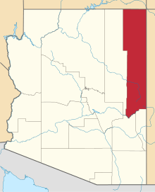 | |
| Towns | ||
| CDPs |
| |
| Unincorporated communities |
| |
| Indian reservations | ||
| Footnotes | ‡This populated place also has portions in an adjacent county or counties | |
This article is issued from Wikipedia - version of the 8/7/2016. The text is available under the Creative Commons Attribution/Share Alike but additional terms may apply for the media files.