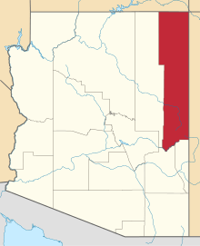
Mexican Water, Arizona
| Mexican Water, Arizona | |
|---|---|
| Unincorporated community | |
 Mexican Water, Arizona  Mexican Water, Arizona | |
| Coordinates: 36°58′01″N 109°38′16″W / 36.96694°N 109.63778°WCoordinates: 36°58′01″N 109°38′16″W / 36.96694°N 109.63778°W | |
| Country | United States |
| State | Arizona |
| County | Apache |
| Elevation | 4,842 ft (1,476 m) |
| Time zone | Mountain (MST) (UTC-7) |
| • Summer (DST) | MDT (UTC-6) |
| Area code(s) | 928 |
| GNIS feature ID | 24516[1] |
Mexican Water is an unincorporated community in Apache County, Arizona, United States. Mexican Water is located on the Navajo Nation 14 miles (23 km) west of Red Mesa.
History
A trading post was established at this site in 1907 under the name Nokaita. It is believed that the current name came from wells that have since disappeared. In July 1, 1939 a bridge was completed 3 miles west of the site because erosion had made the river crossing unusable.[2]
References
- ↑ U.S. Geological Survey Geographic Names Information System: Mexican Water, Arizona
- ↑ Byrd H. Granger (1960). Arizona Place Names. University of Arizona Press. p. 15. Retrieved 5 December 2011.
This article is issued from Wikipedia - version of the 10/19/2016. The text is available under the Creative Commons Attribution/Share Alike but additional terms may apply for the media files.
