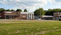
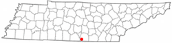
Huntland, Tennessee
| Huntland, Tennessee | |
|---|---|
| Town | |
 | |
 Location of Huntland, Tennessee | |
| Coordinates: 35°3′13″N 86°16′7″W / 35.05361°N 86.26861°WCoordinates: 35°3′13″N 86°16′7″W / 35.05361°N 86.26861°W | |
| Country | United States |
| State | Tennessee |
| County | Franklin |
| Incorporated | 1907[1] |
| Area | |
| • Total | 1.4 sq mi (3.7 km2) |
| • Land | 1.4 sq mi (3.7 km2) |
| • Water | 0.0 sq mi (0.0 km2) |
| Elevation | 942 ft (287 m) |
| Population (2010) | |
| • Total | 872 |
| • Density | 633.2/sq mi (244.5/km2) |
| Time zone | Central (CST) (UTC-6) |
| • Summer (DST) | CDT (UTC-5) |
| ZIP code | 37345 |
| Area code(s) | 931 |
| FIPS code | 47-36600[2] |
| GNIS feature ID | 1288762[3] |
| Website | huntland.us |
Huntland is a town in Franklin County, Tennessee, United States. The population was 916 at the 2000 census and 872 at the 2010 census. It is part of the Tullahoma, Tennessee Micropolitan Statistical Area.
The town was established in the early 1900s, and is named after its founder, Clinton Armstrong Hunt. It was incorporated in 1907.[1] The town is home to a K-12 school, Huntland School.
Geography
Huntland is located at 35°3′13″N 86°16′7″W / 35.05361°N 86.26861°W (35.053508, -86.268678).[4] The town is situated primarily around the intersection of State Highway 122 and State Highway 97, though its boundaries stretch northward to the intersection of State Highway 122 and U.S. Route 64. State Highway 122 continues southwestward to Elora, Tennessee, while State Highway 97 continues southward into Alabama.
According to the United States Census Bureau, the town has a total area of 1.5 square miles (3.9 km2), all of it land.
Demographics
| Historical population | |||
|---|---|---|---|
| Census | Pop. | %± | |
| 1920 | 223 | — | |
| 1930 | 247 | 10.8% | |
| 1940 | 303 | 22.7% | |
| 1950 | 285 | −5.9% | |
| 1960 | 500 | 75.4% | |
| 1970 | 849 | 69.8% | |
| 1980 | 983 | 15.8% | |
| 1990 | 885 | −10.0% | |
| 2000 | 916 | 3.5% | |
| 2010 | 872 | −4.8% | |
| Est. 2015 | 855 | [5] | −1.9% |
| Sources:[6][7] | |||
As of the census[2] of 2000, there were 916 people, 364 households, and 255 families residing in the town. The population density was 633.2 people per square mile (243.9/km²). There were 395 housing units at an average density of 273.1 per square mile (105.2/km²). The racial makeup of the town was 93.12% White, 2.51% African American, 1.09% Native American, 0.11% Asian, 1.64% from other races, and 1.53% from two or more races. Hispanic or Latino of any race were 2.95% of the population.
There were 364 households out of which 29.1% had children under the age of 18 living with them, 51.4% were married couples living together, 14.0% had a female householder with no husband present, and 29.9% were non-families. 28.6% of all households were made up of individuals and 15.4% had someone living alone who was 65 years of age or older. The average household size was 2.47 and the average family size was 3.00.
In the town the population was spread out with 22.6% under the age of 18, 8.6% from 18 to 24, 28.1% from 25 to 44, 23.1% from 45 to 64, and 17.6% who were 65 years of age or older. The median age was 39 years. For every 100 females there were 90.8 males. For every 100 females age 18 and over, there were 89.6 males.
The median income for a household in the town was $30,417, and the median income for a family was $38,125. Males had a median income of $27,500 versus $21,905 for females. The per capita income for the town was $16,676. About 10.8% of families and 13.2% of the population were below the poverty line, including 19.7% of those under age 18 and 20.3% of those age 65 or over.
References
- 1 2 Town of Huntland official website. Accessed 4 May 2015.
- 1 2 "American FactFinder". United States Census Bureau. Archived from the original on September 11, 2013. Retrieved 2008-01-31.
- ↑ "US Board on Geographic Names". United States Geological Survey. 2007-10-25. Retrieved 2008-01-31.
- ↑ "US Gazetteer files: 2010, 2000, and 1990". United States Census Bureau. 2011-02-12. Retrieved 2011-04-23.
- ↑ "Annual Estimates of the Resident Population for Incorporated Places: April 1, 2010 to July 1, 2015". Retrieved July 2, 2016.
- ↑ "Census of Population and Housing: Decennial Censuses". United States Census Bureau. Retrieved 2012-03-04.
- ↑ "Incorporated Places and Minor Civil Divisions Datasets: Subcounty Resident Population Estimates: April 1, 2010 to July 1, 2012". Population Estimates. U.S. Census Bureau. Archived from the original on June 17, 2013. Retrieved 11 December 2013.
External links
Municipalities and communities of Franklin County, Tennessee, United States | ||
|---|---|---|
| Cities | ||
| Towns | ||
| CDP | ||
| Unincorporated communities | ||
| Ghost town | ||
| Footnotes | ‡This populated place also has portions in an adjacent county or counties | |