Huron River (Michigan)
| Huron River | |
|---|---|
 Huron River in Ypsilanti | |
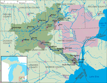 A map of the Huron River and its watershed. | |
| Country | United States |
| Basin | |
| Main source |
Huron Swamp south of Andersonville, Michigan 1,001 ft (305 m) |
| River mouth |
Lake Erie southeast of Rockwood, Michigan 571 ft (174 m) |
| Basin size | 908 sq mi (2,350 km2) |
| Physical characteristics | |
| Length | 130 mi (210 km) |
The Huron River is a 130-mile-long (210 km)[1] river in southeastern Michigan, rising out of the Huron Swamp in Indian Springs Metropark in White Lake Township in northern Oakland County and flowing into Lake Erie on the boundary between Wayne County and Monroe County. In addition to thirteen parks, game areas, and recreation areas, the river passes through the cities of Dexter, Ann Arbor, Ypsilanti, Belleville, Flat Rock and Rockwood.
The Huron River is a typical Southeast Michigan stream; mud banks, slow stream flow and a low gradient define this river. It runs through the following counties, in order from the headwaters to its mouth: Oakland, Livingston, Washtenaw, Wayne, and Monroe. There are 24 major tributaries totaling about 370 miles (600 km) in addition to the mainstream. The Huron River watershed drains 908 square miles (2,350 km2). It is the only state-designated Country-Scenic Natural River in southeast Michigan. This includes 27.5 miles (44.3 km) of the mainstream, plus an additional 10.5 miles (16.9 km) of three tributaries.
The river was named after the Huron band of Native Americans who lived in the area. In Native languages, it was called cos-scut-e-nong sebee or Giwitatigweiasibi. It was part of a Native American trade route.
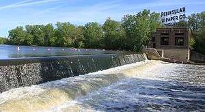
The river has many dams, 19 on the mainstream and at least 96 in the entire system. Most dams are only a few feet high, built to slightly increase and maintain water levels in existing lakes to provide drought protection and flood control, a use that is now environmentally controversial. However, at least a dozen dams were built for mill or hydroelectric power and several formed large new lakes behind them. Some of these on the Huron River mainstream are Kent Lake, Barton Pond, Argo Pond, Ford Lake, Belleville Lake, and Flat Rock Pond.
The Huron River flows through numerous parks and is a prime canoeing river with a generally slow current and only a few minor rapids or obstructions, except for the short Delhi rapids which is runnable by experienced canoeists and kayakers except during low water.
The river is heavily fished by sportsmen for rock bass, sunfish, bluegill, black crappie, white bass, smallmouth bass, largemouth bass, northern pike, walleye, catfish, trout, muskie, and below Belleville Dam, Coho salmon, Chinook salmon, and Steelhead. Suckers and carp are also common fish in the river.
In 2009, faculty and students from the University of Michigan produced "Mapping the River," a multimedia presentation combining dance, poetry, music, and projected images which explored the role of the Huron in communities along it.[2]
History
The Huron River was declared navigable by Congress in the 19th century, and for a time, there was flat-boat traffic from Ypsilanti to Lake Erie. This was discontinued as the railroads penetrated the region and milling developed along the river. By the 1880s, the Huron River was considered peculiar among the rivers in the region because it was intensely exploited for water-powered manufacturing. The census reported a total of 17 developed mill dams on the river, many providing power to multiple mills. Flour milling dominated, but there were also sawmills and woolen mills.[3] As the 20th century began, the Detroit Edison Company and Ford Motor Company began acquiring and developing dams along the river for electric power.[4][5]
Floods
Notable floods have occurred on March 23, 1904, March 14, 1918, June 24, 1968, and March 15, 1982.[6]
Tributaries
Significant tributaries of the Huron River are listed below, in order of progression upstream. Sub-tributaries are indented below their parent watercourse.
- Smith Creek
- Silver Creek
- Port Creek
- Willow Run
- Fleming Creek
- Swift Run
- Malletts Creek
- Traver Creek
- Allen Creek
- Boyden Creek
- Honey Creek
- Millers Creek
- Portage Creek
- Livermore Creek
- Arms Creek
- Honey Creek
- Hay Creek
- Chilson Creek
- Horseshoe Lake Creek
- South Ore Creek
- Davis Creek
- Woodruff Creek
- Mann Creek
- Pettibone Creek
- Norton Creek
Path
The river flows through the following parks and cities in this order starting from the headwaters:
- Indian Springs Metropark
- Pontiac Lake Recreation Area
- Proud Lake State Recreation Area
- Milford
- Camp Dearborn
- Kensington Metropark
- Island Lake Recreation Area
- Huron Meadows Metropark
- Hudson Mills Metropark
- Dexter
- Dexter–Huron Metropark
- Delhi Metropark
- Ann Arbor
- Ypsilanti
- Lower Huron Metropark
- Willow Metropark
- Oakwoods Metropark
- Lake Erie Metropark
- Pointe Mouillee State Game Area
Historical name confusion with Clinton River
The Clinton River was also known as the Huron River until 1824. Although the Clinton River drains into Lake St. Clair north of Detroit, it is also located in southeast Michigan and shares about 10 miles (16 km) of watershed boundary with the Huron River system. The Clinton River was renamed on July 17, 1824, by the Michigan Territorial Council to avoid confusion between the two rivers.[8]
References
- ↑ U.S. Geological Survey. National Hydrography Dataset high-resolution flowline data. The National Map, accessed November 7, 2011
- ↑ Mannino, Trina (12 February 2009), "University profs celebrate the Huron in 'Mapping the River'", The Michigan Daily, Ann Arbor, MI
- ↑ James L. Greenleaf, Report on the Water-Powers of the Drainage Basins of Lakes Huron and Erie, Eastern Drainage Area of the Lower Peninsula of Michigan, Huron River, Description of Developed Power, in Water Power of the United States, Part I Department of the Interior, Census Office, GPO, Washington, 1885; page 494.
- ↑ General Electrical News, Power Plants, Detroit Mich. Electricity Vol. 30, No. 8 (Feb. 21, 1908); page 111.
- ↑ The Huron River: Voices from the Watershed, edited by John Ray Knott, Keith Taylor, University of Michigan Press, 2000, p. 194
- ↑ Bien, Laura (2010-03-23). "The bridge-crushing flood of 1904". Ypsilanti Citizen. Retrieved 2010-03-26.
On March 15, 1982, two canoeistss capsized in fast currents and were marooned on the tiny island just south of the Tridge...On June 24, 1968, a flood blew out the Dixboro dam, sending a massive wave downstream that drained the big ponds in Gallup Park...On March 14, 1918, a flood collapsed the center of the Michigan Avenue Bridge, pinching several parked cars in jagged concrete jaws...But the March 23, 1904 flood was among the worst.
- ↑ Nichols Arboretum
- ↑ Leeson, Michael A. (2005) [1882]. "Organization". History of Macomb County. Ann Arbor, Mich.: University of Michigan Library. p. 297. Retrieved 2006-10-01.
External links
![]() Media related to Huron River (Michigan) at Wikimedia Commons
Media related to Huron River (Michigan) at Wikimedia Commons
- Huron River Watershed Council
- History of Peninsular Dam
- U.S. Geological Survey Geographic Names Information System: Huron River
- USGS river level data, at Ann Arbor
| Topics |  | |
|---|---|---|
| Detroit | ||
| Municipalities over 80,000 | ||
| Municipalities 40,000 to 80,000 | ||
| Cultural enclaves | ||
| Satellite cities | ||
| Counties in MSA | ||
| Counties in CSA | ||
Coordinates: 42°1′47″N 83°11′15″W / 42.02972°N 83.18750°W