Brighton, Michigan
| Brighton, Michigan | |
|---|---|
| City | |
|
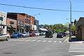
Downtown Brighton, Grand River Ave | |
| Motto: "Where quality is a way of life" | |
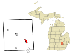 Location of Brighton, Michigan | |
| Coordinates: 42°31′36″N 83°47′2″W / 42.52667°N 83.78389°W | |
| Country | United States |
| State | Michigan |
| County | Livingston |
| Government | |
| • Mayor | Jim Muzzin[1] |
| Area[2] | |
| • Total | 3.69 sq mi (9.56 km2) |
| • Land | 3.56 sq mi (9.22 km2) |
| • Water | 0.13 sq mi (0.34 km2) |
| Elevation | 925 ft (282 m) |
| Population (2010)[3] | |
| • Total | 7,444 |
| • Estimate (2012[4]) | 7,552 |
| • Density | 2,091.0/sq mi (807.3/km2) |
| Time zone | Eastern (EST) (UTC-5) |
| • Summer (DST) | EDT (UTC-4) |
| ZIP codes | 48114,48115,48116 |
| Area code(s) | 810 248 |
| FIPS code | 26-10620[5] |
| GNIS feature ID | 0621987[6] |
| Website | Brighton City Website |

Brighton is a suburb in metro Detroit located in the southeast portion of Livingston County in the U.S. state of Michigan. As of the 2010 census, the city population was 7,444. Brighton forms part of the South Lyon-Howell-Brighton Urban Area. It is one of two incorporated cities in Livingston County, and incorporates land that was once part of Brighton, Green Oak and Genoa townships.
History
Brighton was established in 1832. It was incorporated as a village in 1867 and as a city in 1928.[7]
Geography
According to the United States Census Bureau, the city has a total area of 3.69 square miles (9.56 km2), of which 3.56 square miles (9.22 km2) is land and 0.13 square miles (0.34 km2) is water.[2]
Transportation
Time from Brighton to:
Major Thoroughfares
Climate
Brighton exhibits what is known as a continental climate biome. Within the heart of the Great Lakes region, Brighton weather ranges from warm summers with occasional thunderstorms to cold, dry winters with moderate to heavy snowfall. Brighton has many parks nearby for fall foliage viewing including Brighton Recreation Area and Kensington Metro Park.
Brighton area lakes are suitable for swimming from the standard Memorial Day to Labor Day schedule, and depending on yearly weather conditions, longer.
| Climate data for Brighton, Michigan | |||||||||||||
|---|---|---|---|---|---|---|---|---|---|---|---|---|---|
| Month | Jan | Feb | Mar | Apr | May | Jun | Jul | Aug | Sep | Oct | Nov | Dec | Year |
| Record high °F (°C) | 66 (19) |
67 (19) |
79 (26) |
86 (30) |
92 (33) |
101 (38) |
100 (38) |
98 (37) |
96 (36) |
88 (31) |
78 (26) |
64 (18) |
101 (38) |
| Average high °F (°C) | 30 (−1) |
33 (1) |
43 (6) |
56 (13) |
68 (20) |
77 (25) |
82 (28) |
79 (26) |
72 (22) |
59 (15) |
46 (8) |
34 (1) |
56.6 (13.7) |
| Average low °F (°C) | 14 (−10) |
16 (−9) |
24 (−4) |
35 (2) |
47 (8) |
56 (13) |
60 (16) |
59 (15) |
51 (11) |
40 (4) |
31 (−1) |
20 (−7) |
37.8 (3.2) |
| Record low °F (°C) | −23 (−31) |
−16 (−27) |
−9 (−23) |
11 (−12) |
24 (−4) |
33 (1) |
41 (5) |
38 (3) |
26 (−3) |
16 (−9) |
−1 (−18) |
−18 (−28) |
−23 (−31) |
| Average precipitation inches (mm) | 1.52 (38.6) |
1.55 (39.4) |
2.13 (54.1) |
2.78 (70.6) |
2.83 (71.9) |
3.12 (79.2) |
2.52 (64) |
3.07 (78) |
3.00 (76.2) |
2.10 (53.3) |
2.47 (62.7) |
2.19 (55.6) |
29.28 (743.7) |
| Source: WeatherChannel[8] | |||||||||||||
Demographics
| Historical population | |||
|---|---|---|---|
| Census | Pop. | %± | |
| 1860 | 252 | — | |
| 1870 | 454 | 80.2% | |
| 1880 | 803 | 76.9% | |
| 1890 | 741 | −7.7% | |
| 1900 | 781 | 5.4% | |
| 1910 | 767 | −1.8% | |
| 1920 | 800 | 4.3% | |
| 1930 | 1,287 | 60.9% | |
| 1940 | 1,353 | 5.1% | |
| 1950 | 1,861 | 37.5% | |
| 1960 | 2,282 | 22.6% | |
| 1970 | 2,457 | 7.7% | |
| 1980 | 4,268 | 73.7% | |
| 1990 | 5,686 | 33.2% | |
| 2000 | 6,701 | 17.9% | |
| 2010 | 7,444 | 11.1% | |
| Est. 2015 | 7,609 | [9] | 2.2% |
The median income for a household in the city in 2009 was $47,668, and the median income for a family was $77,105.[11] Males had a median income of $48,554 versus $30,877 for females. The per capita income for the city was $29,781. Brighton's surrounding townships and communities, such as Brighton and Genoa Township, have median household incomes in excess of $90,000, making it one of the more prosperous places in Michigan. Additionally, about 3.0% of families and 5.1% of the population were below the poverty line, including 5.9% of those under age 18 and 5.2% of those age 65 or over in the 2000 census.
2010 census
As of the census[3] of 2010, there were 7,444 people, 3,603 households, and 1,811 families residing in the city. The population density was 2,091.0 inhabitants per square mile (807.3/km2). There were 3,905 housing units at an average density of 1,096.9 per square mile (423.5/km2). The racial makeup of the city was 96.0% White, 0.7% African American, 0.4% Native American, 1.1% Asian, 0.6% from other races, and 1.2% from two or more races. Hispanic or Latino of any race were 2.3% of the population.
There were 3,603 households of which 22.3% had children under the age of 18 living with them, 38.2% were married couples living together, 8.9% had a female householder with no husband present, 3.1% had a male householder with no wife present, and 49.7% were non-families. 42.7% of all households were made up of individuals and 19.8% had someone living alone who was 65 years of age or older. The average household size was 2.02 and the average family size was 2.81.
The median age in the city was 43.4 years. 19% of residents were under the age of 18; 7.1% were between the ages of 18 and 24; 26% were from 25 to 44; 26.1% were from 45 to 64; and 21.7% were 65 years of age or older. The gender makeup of the city was 46.2% male and 53.8% female.
2000 census
As of the census[5] of 2000, there were 6,701 people, 3,103 households, and 1,746 families residing in the city. The population density was 1,857.0 per square mile (716.7/km²). There were 3,241 housing units at an average density of 898.2 per square mile (346.6/km²). The racial makeup of the city was 99.76% White, 0.034% African American, 0.042% Native American, 0.21% Asian, 0.39% from other races, and 0.0093% from two or more races. Hispanic or Latino of any race were 1.48% of the population.
There were 3,103 households out of which 25.7% had children under the age of 18 living with them, 44.3% were married couples living together, 9.1% had a female householder with no husband present, and 43.7% were non-families. 37.8% of all households were made up of individuals and 15.5% had someone living alone who was 65 years of age or older. The average household size was 2.15 and the average family size was 2.87.
In the city the population was spread out with 21.7% under the age of 18, 8.5% from 18 to 24, 31.9% from 25 to 44, 21.4% from 45 to 64, and 16.6% who were 65 years of age or older. The median age was 37 years. For every 100 females there were 87.6 males. For every 100 females age 18 and over, there were 81.8 males.
Education
Brighton is served by
- Brighton Area Schools
- Flextech High School
- Charyl Stockwell Academy
- St. Patrick Elementary and Middle School (Catholic)
- Maple Tree Montessori Academy
- Shepherd of the Lakes Lutheran: preschool - sixth grade
- Cornerstone Christian School
- Holy Spirit Roman Catholic School
- The Bridge
Satellites of Colleges
Government
The city of Brighton's wastewater treatment plant facility is located in Hamburg Township and services the city of Brighton and parts of Genoa, Brighton, and Hamburg townships. The city's two water plants also services both the city and parts of Genoa, Brighton and Hamburg townships.
Fire service for the city is provided through a separate governmental entity called the Brighton Area Fire Authority, which also services the Townships of Brighton and Genoa.
Library services for the city is provided through a separate governmental entity called the Brighton District Library, which also services the townships of Brighton, Genoa and Green Oak.
Recreation services for the city is provided through a separate governmental entity called the Southeastern Livingston County Recreation Authority, which also services the townships of Brighton, Genoa and Green Oak, as well as the Brighton Area Schools.
Business district
The town's major business districts are located downtown and on either side of town. Brighton has two major shopping malls: Brighton Mall on the west side of town is a former enclosed mall which was rebuilt in 1996 as a power center, and Green Oak Village Place is a lifestyle center complex on the east side of town.
Several initiatives to revitalize downtown, such as streetscape improvements and displayed art, have been well received. A bronze nude entitled Decision Pending, purchased as part of the 2006 Brighton Biennial, generated some controversy and an unsuccessful campaign to relocate the statue.[12][13][14]
Popular culture
In the fifth episode of Studio 60 on the Sunset Strip (105), the character Harriet Hayes (played by actress Sarah Paulson) was born and raised in Brighton.
The film Aspen Extreme begins in Brighton, with the two main characters being maintenance staff at the local ski hill, Mt. Brighton.
The 1987 horror film The Gate, starring a young Stephen Dorff, had its world premier at the Brighton Cinemas in Brighton. The film's producers wanted to hold its official premier in the town of Hell, Michigan, but Brighton was the nearest town with a theater large enough to hold the event. Dorff and the other stars of the movie attended the premier.
Notable people
- Drew Henson, quarterback for the Houston Texans, Dallas Cowboys, Minnesota Vikings, and Detroit Lions; attended Brighton High School
- Mickey Stanley, center fielder for the Detroit Tigers; World Series champion (1968); lives in Brighton
- Morgan Trent, cornerback for the Cincinnati Bengals, Indianapolis Colts, Jacksonville Jaguars, and Washington Redskins; lived in Brighton
Gallery
 Downtown Brighton, Main St.
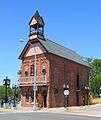 Old Town Hall
 Old Town Hall historical marker
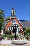 St. Paul's Episcopal Church
 St. Paul's Episcopal Church historical marker
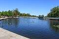 Millpond Park
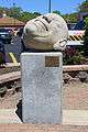 "Bob" sculpture, Main St. & Grand River Ave.
References
- ↑ "City of Brighton, Michigan - City Council". City of Brighton, Michigan. Retrieved 22 September 2014.
- 1 2 "US Gazetteer files 2010". United States Census Bureau. Archived from the original on 2012-01-24. Retrieved 2012-11-25.
- 1 2 "American FactFinder". United States Census Bureau. Retrieved 2012-11-25.
- ↑ "Population Estimates". United States Census Bureau. Archived from the original on 2013-06-17. Retrieved 2013-06-03.
- 1 2 "American FactFinder". United States Census Bureau. Archived from the original on 2013-09-11. Retrieved 2008-01-31.
- ↑ "US Board on Geographic Names". United States Geological Survey. 2007-10-25. Retrieved 2008-01-31.
- ↑ Romig, Walter (1973). Michigan Place Names. Wayne State University Press. p. 78. ISBN 978-0814318386. Retrieved 2013-09-26.
- ↑ "Monthly Weather for Brighton, MI 48114". The Weather Channel. Retrieved 2013-09-26.
- ↑ "Annual Estimates of the Resident Population for Incorporated Places: April 1, 2010 to July 1, 2015". Retrieved July 2, 2016.
- ↑ "Census of Population and Housing". Census.gov. Archived from the original on May 11, 2015. Retrieved June 4, 2015.
- ↑ American FactFinder Archived April 17, 2014, at the Wayback Machine.
- ↑ Moorehouse, Buddy (2010). "Woo-hoo! The Ugly Naked Guy is on the move". LivingstonTalk.com. Archived from the original on 2012-01-06.
- ↑ "Brighton Relocating 'Decision Pending' Statue". myFOXDetroit.com. 2010-08-23. Archived from the original on 2010-08-25.
- ↑ "City Of Brighton City Council Meeting, City Hall, October 7, 2010" (PDF). Archived from the original (PDF) on September 29, 2013.
External links
- Brighton City Web Site
- Livingston County Visitors' Bureau's Website
- Greater Brighton Area Chamber of Commerce
- Livingston County Small Business & Technology Development Center
Coordinates: 42°31′46″N 83°46′49″W / 42.52944°N 83.78028°W
Municipalities and communities of Livingston County, Michigan, United States | ||
|---|---|---|
| Cities | 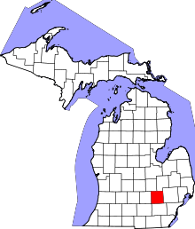 | |
| Villages | ||
| Charter townships | ||
| General law townships | ||
| Unincorporated communities |
| |
| Footnotes | ‡This populated place also has portions in an adjacent county or counties | |