Imboden, Arkansas
| Imboden, Arkansas | |
|---|---|
| City | |
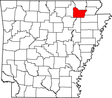
 Location in Lawrence County and the state of Arkansas | |
| Coordinates: 36°12′6″N 91°10′48″W / 36.20167°N 91.18000°WCoordinates: 36°12′6″N 91°10′48″W / 36.20167°N 91.18000°W | |
| Country | United States |
| State | Arkansas |
| County | Lawrence |
| Area | |
| • Total | 0.9 sq mi (2.3 km2) |
| • Land | 0.9 sq mi (2.3 km2) |
| • Water | 0 sq mi (0 km2) |
| Elevation | 315 ft (96 m) |
| Population (2010) | |
| • Total | 677 |
| • Density | 752.2/sq mi (294.3/km2) |
| Time zone | Central (CST) (UTC-6) |
| • Summer (DST) | CDT (UTC-5) |
| ZIP code | 72434 |
| Area code(s) | 870 |
| FIPS code | 05-34150 |
| GNIS feature ID | 0057965 |
Imboden is a city[1] in Lawrence County, Arkansas, United States. The population was 677 at the 2000 census. It is named after a family of settlers.
History
The community was first settled around 1828 and was incorporated in 1887.
In 1912, Imboden elected Joe Sullivan as the youngest elected mayor in the United States of that period. He was 21 years old and paralyzed so relied on a goat-driven cart. He left the town in 1914 to pursue further education. [2]
Imboden has two public schools. Sloan-Hendrix School was established in 1899 as Sloan-Hendrix Academy, a private school affiliated with Hendrix College in Conway. It later became a public school.[3] Imboden Area Charter School, an open-enrollment public charter school, opened in 2002.[4]
Geography
Imboden is located at 36°12′6″N 91°10′48″W / 36.20167°N 91.18000°W (36.201766, -91.179899).[5]
According to the United States Census Bureau, the town has a total area of 0.9 square miles (2.3 km2), all land.
List Of Highways
Demographics
| Historical population | |||
|---|---|---|---|
| Census | Pop. | %± | |
| 1890 | 157 | — | |
| 1900 | 411 | 161.8% | |
| 1910 | 600 | 46.0% | |
| 1920 | 630 | 5.0% | |
| 1930 | 564 | −10.5% | |
| 1940 | 525 | −6.9% | |
| 1950 | 447 | −14.9% | |
| 1960 | 400 | −10.5% | |
| 1970 | 496 | 24.0% | |
| 1980 | 661 | 33.3% | |
| 1990 | 616 | −6.8% | |
| 2000 | 684 | 11.0% | |
| 2010 | 677 | −1.0% | |
| Est. 2015 | 640 | [6] | −5.5% |
As of the census[8] of 2000, there were 684 people, 308 households, and 194 families residing in the town. The population density was 760.5 people per square mile (293.4/km²). There were 343 housing units at an average density of 381.3/sq mi (147.1/km²). The racial makeup of the town was 98.25% Whites, 0.73% Native Americans, and 1.02% from two or more races. 0.29% of the population were Hispanics or Latinos of any race.
There were 308 households out of which 24.4% had children under the age of 18 living with them, 54.9% were married couples living together, 6.2% had a female householder with no husband present, and 37.0% were non-families. 35.7% of all households were made up of individuals and 23.4% had someone living alone who was 65 years of age or older. The average household size was 2.22 and the average family size was 2.85.
In the town the population was spread out with 23.0% under the age of 18, 6.9% from 18 to 24, 22.7% from 25 to 44, 22.1% from 45 to 64, and 25.4% who were 65 years of age or older. The median age was 43 years. For every 100 females there were 82.4 males. For every 100 females age 18 and over, there were 82.4 males.
The median income for a household in the town was $24,489, and the median income for a family was $33,438. Males had a median income of $28,977 versus $16,667 for females. The per capita income for the townfasd was $14,361. About 11.1% of families and 17.8% of the population were below the poverty line, including 28.4% of those under age 18 and 9.8% of those age 65 or over.
Education
Public education is provided by:
- Sloan–Hendrix School District, which leads to graduation from Sloan–Hendrix High School.
- Imboden Area Charter School, an open-enrollment school for kindergarten through eighth grade.
References
- ↑ Local.Arkansas.gov - Imboden, retrieved September 3, 2012
- ↑ THE STORY OF IMBODEN ARKANSAS Part Two By Reta Covey Published in Walnut Ridge The Times Dispatch in 1975 From the Lawrence County Historical Society Winter 1982 - Volume 5 - Number 1
- ↑ http://shsd.k12.ar.us/History.htm Sloan-Hendrix history
- ↑ http://www.imbodencharter.com/general-information/about/ Imboden Area Charter School
- ↑ "US Gazetteer files: 2010, 2000, and 1990". United States Census Bureau. 2011-02-12. Retrieved 2011-04-23.
- ↑ "Annual Estimates of the Resident Population for Incorporated Places: April 1, 2010 to July 1, 2015". Retrieved July 2, 2016.
- ↑ "Census of Population and Housing". Census.gov. Archived from the original on May 11, 2015. Retrieved June 4, 2015.
- ↑ "American FactFinder". United States Census Bureau. Archived from the original on September 11, 2013. Retrieved 2008-01-31.
