Indian Regional Navigation Satellite System
| Country of origin |
|
|---|---|
| Operator(s) | ISRO |
| Type | Military, Commercial |
| Status | Operational |
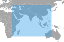
| Coverage | Regional (up to 1,500 km from borders) |
| Precision |
10 m (public) 0.1 m (encrypted) |
| Constellation size | |
| Total satellites | 7 |
| Satellites in orbit | 7 |
| First launch | 1 July 2013 |
| Last launch | 28 April 2016 12:50 pm IST |
| Total launches | 7 (All Successful) |
| Orbital characteristics | |
| Regime(s) | High Earth |
| Orbital height | 36,000 km (22,000 mi)[1] |
| Other details | |
| Cost | $212 million |
| Geodesy | ||||||||||||||||
|---|---|---|---|---|---|---|---|---|---|---|---|---|---|---|---|---|
 | ||||||||||||||||
| Fundamentals | ||||||||||||||||
| Concepts | ||||||||||||||||
| Technologies | ||||||||||||||||
| Standards | ||||||||||||||||
|
||||||||||||||||
| History | ||||||||||||||||
The Indian Regional Navigation Satellite System (IRNSS) with an operational name of NAVIC ("sailor" or "navigator" in Sanskrit, Hindi and many other Indian languages, which also stands for NAVigation with Indian Constellation[2]) is an autonomous regional satellite navigation system that is being set up by India, that will be used to provide accurate real-time positioning and timing services over India and the region extending to 1,500 kilometres (930 mi) around India. The NAVIC system will consist of a constellation of 3 satellites in Geostationary orbit (GEO), 4 satellites in Geosynchronous orbit (GSO), approximately 36,000 kilometres (22,000 mi) altitude above earth surface,[1][3] and two satellites on the ground as stand-by,[4] in addition to ground stations. The system was developed because access to foreign government-controlled global navigation satellite systems is not guaranteed in hostile situations, as happened to the Indian military in 1999 when it was dependent on the American Global Positioning System (GPS) during the Kargil War.[5] The Indian government approved the project in May 2006.
The constellation of seven NAVIC satellites is already in orbit and the system is expected to be operational from September 2016,[6][7] after a system check.[8] NAVIC will provide two levels of service, the standard positioning service will be open for civilian use, and a restricted service (an encrypted one) for authorized users (including the military).
Development
As part of the project, the Indian Space Research Organisation (ISRO) opened a new satellite navigation center within the campus of ISRO Deep Space Network (DSN) at Byalalu, in Karnataka on 28 May 2013.[9] A network of 21 ranging stations located across the country will provide data for the orbital determination of the satellites and monitoring of the navigation signal.
A goal of complete Indian control has been stated, with the space segment, ground segment and user receivers all being built in India. Its location in low latitudes facilitates a coverage with low-inclination satellites. Three satellites will be in geostationary orbit over the Indian Ocean. Missile targeting could be an important military application for the constellation.[10]
The total cost of the project is expected to be ₹1,420 crore (US$211 million), with the cost of the ground segment being ₹300 crore (US$45 million). Each satellites costing ₹150 crore (US$22 million) and the PSLV-XL version rocket costs around ₹130 crore (US$19 million) . The seven rockets would involve an outlay of around ₹910 crore (US$135 million).[4][11][12] The NAVIC signal was released for evaluation in September 2014.[13]
Time-Frame
In April 2010, it was reported that India plans to start launching satellites by the end of 2011, at a rate of one satellite every six months. This would have made NAVIC functional by 2015. But the program was delayed,[14] and India also launched 3 new satellites to supplement this.[15]
Seven satellites with the prefix "IRNSS-1" will constitute the space segment of the IRNSS. IRNSS-1A, the first of the seven satellites, was launched on 1 July 2013.[16][17] IRNSS-1B was launched on 4 April 2014 on board the PSLV-C24 rocket. The satellite has been placed in geosynchronous orbit.[18] IRNSS-1C was launched on 16 October 2014,[19] IRNSS-1D on 28 March 2015,[20] IRNSS-1E on 20 January 2016,[21]IRNSS-1F on 10 March 2016 and IRNSS-1G was launched on 28 April 2016.[22]
Description
The system consists of a constellation of seven satellites and a support ground segment. Three of the satellites in the constellation are located in geostationary orbit (GEO) at 32.5° East, 83° East, and 131.5° East longitude. The other four are inclined geosynchronous orbit (GSO). Two of the GSOs cross the equator at 55° East and two at 111.75° East.[23] The four GSO satellites will appear to be moving in the form of an "8".[24] In addition, various ground-based systems will control, track orbits, check integration and send radio signals to the satellites. The land-based Master Control Center (MCC) will run navigational software.[25]
NAVIC signals will consist of a Standard Positioning Service and a Precision Service. Both will be carried on L5 (1176.45 MHz) and S band (2492.028 MHz). The SPS signal will be modulated by a 1 MHz BPSK signal. The Precision Service will use BOC(5,2). The navigation signals themselves would be transmitted in the S-band frequency (2–4 GHz) and broadcast through a phased array antenna to maintain required coverage and signal strength. The satellites would weigh approximately 1,330 kg and their solar panels generate 1,400 watts. The system is intended to provide an absolute position accuracy of better than 10 meters throughout Indian landmass and better than 20 meters in the Indian Ocean as well as a region extending approximately 1,500 km around India.[26]
Satellites
IRNSS-1A
IRNSS-1A was the first out of seven navigational satellite in the Indian Regional Navigation Satellite System (IRNSS) series of satellites to be placed in geosynchronous orbit.[27][28] It was built at ISRO Satellite Centre, Bangalore, costing ₹125 crore (US$19 million).[11][12][16][29] It has a lift-off mass of 1380 kg, and carries a navigation payload and a C band ranging transponder, which operates in L5 band (1176.45 MHz) and S band (2492.028 MHz).[30] An optimised I-1K bus structure with a power handling capability of around 1600 watts is used and is designed for a ten-year mission.[31][32] The satellite was launched on-board PSLV-C22 on 1 July 2013 from the Satish Dhawan Space Centre at Sriharikota.[16][17][33]
IRNSS-1B
Satellite IRNSS-1B was placed in geosynchronous orbit on 4 April 2014[34] aboard the PSLV-C24 rocket from Satish Dhawan Space Centre, Sriharikota.[35][36] The satellite will provide navigation, tracking and mapping services.[37]
The IRNSS-1B satellite weighs 1,432 kg and has two payloads: a navigation payload and CDMA ranging payload in addition with a laser retro-reflector. The payload generates navigation signals at L5 and S-band. The design of the payload makes the IRNSS system interoperable and compatible with GPS and Galileo.[34] The satellite is powered by two solar arrays, which generate power up to 1,660 watts, and has a life-time of ten years.
IRNSS-1C
Satellite IRNSS-1C was placed in geostationary orbit[38][34][39] on 16 October 2014[40][41] aboard PSLV-C26 from the Satish Dhawan Space Centre, Sriharikota.
The IRNSS-1C satellite has two payloads: a navigation payload and CDMA ranging payload in addition with a laser retro-reflector. The payload generates navigation signals at L5 and S-band. The design of the payload makes the IRNSS system interoperable and compatible with GPS and Galileo.[34] The satellite is powered by two solar arrays, which generate power up to 1,660 watts, and has a life-time of ten years.
IRNSS-1D
IRNSS-1D is the fourth IRNSS satellite. It was launched using India's PSLV-C27 on 28 March 2015.[28][42]
IRNSS-1E
IRNSS-1E is the fifth IRNSS satellite. It was launched on 20 January 2016 using India's PSLV-C31.[43][44]
IRNSS-1F
IRNSS-1F is the sixth IRNSS satellite. It was launched on 10 March 2016 using India's PSLV-C32.[7][43]
IRNSS-1G
IRNSS-1G is the seventh IRNSS satellite. It was launched on 28 April 2016 using India's PSLV-C33, which concludes the setting up of the Indian Regional Navigation Satellite System.[45]
See also
References
- 1 2 "Orbit height and info".
- ↑ "IRNSS-1G exemplifies 'Make in India', says PM". The Statesman. 28 April 2016. Retrieved 28 April 2016.
- ↑ "IRNSS details".
- 1 2 "Isro to launch 5th navigation satellite on Jan 20, first in 2016".
- ↑ Srivastava, Ishan (5 April 2014). "How Kargil spurred India to design own GPS". The Times of India. Retrieved 9 December 2014.
- ↑ "India to have its own fully-functional GPS system by June 2016: ISRO".
- 1 2 "Isro's PSLV-C32 places India's sixth navigation satellite IRNSS-1F in orbit". Times of India.
- ↑ "ISRO puts seventh and final IRNSS navigation satellite into orbit". Times of India.
- ↑ "ISRO opens navigation centre for satellite system". Zeenews.com. 2013-05-28. Retrieved 30 June 2013.
- ↑ "India Making Strides in Satellite Technology". Defence News. Retrieved 26 July 2012.
- 1 2 "India's first ever dedicated navigation satellite launched". DNA India. 2 July 2013. Retrieved 24 July 2013.
- 1 2 "India's first dedicated navigation satellite placed in orbit". NDTV. 2 July 2013. Retrieved 24 July 2013.
- ↑ "IRNSS Signal in Space ICD Released". gpsworld.com. 25 September 2014. Retrieved 7 September 2016.
- ↑ S. Anandan (10 April 2010). "Launch of first satellite for Indian Regional Navigation Satellite system next year". Beta.thehindu.com. Retrieved 2010-12-30.
- ↑ H. Pathak. "3 Satellites To Be Launched By ISRO".
- 1 2 3 "ISRO's Future programme". ISRO. Retrieved 18 May 2013.
- 1 2 "Countdown begins for PSLV-C22 launch". thehindubusinessline.com. Retrieved 2013-06-29.
- ↑ "Isro successfully launches navigation satellite IRNSS-1B". Times Of India. Retrieved 4 April 2014.
- ↑ "ISRO puts India's Navigation satellite IRNSS 1B into orbit". IANS. news.biharprabha.com. Retrieved 4 April 2014.
- ↑ "India successfully launches IRNSS-1D, fourth of seven navigation satellites - Times of India". indiatimes.com. Retrieved 7 September 2016.
- ↑ "India launches 5th navigation satellite IRNSS-1E powered by PSLV rocket". hindustantimes.com. Retrieved 2016-01-20.
- ↑ Narasimhan, T. E. "India gets its own GPS with successful launch of 7th navigation satellite". business-standard.com. Retrieved 7 September 2016.
- ↑ "First IRNSS satellite by December". Magazine article. Asian Surveying and Mapping. 5 May 2009. Retrieved 2009-05-05.
- ↑ "How Kargil spurred India to design own GPS". The Times of India. 5 April 2014. Retrieved 28 April 2016.
- ↑ K. Radhakrishnan (29 December 2013). "Mars and more, final frontier". Deccan Chronicle. Retrieved 28 April 2016.
- ↑ A. Bhaskaranarayana Director SCP/FMO & Scientific Secretary Indian Space Research Organisation – Indian IRNSS and GAGAN
- ↑ "IRNSS-1A". n2yo. Retrieved 26 July 2013.
- 1 2 "IRNSS". space.skyrocket.de. Retrieved 2012-04-08.
- ↑ "ISRO Forthcoming Satellite launches". ISRO. Retrieved 24 September 2011.
- ↑ "IRNSS-1A". ISRO. 1 July 2013. Retrieved 2 August 2013.
- ↑ "India to launch first navigational satellite on June 12". Zee news. 18 May 2013. Retrieved 18 May 2013.
- ↑ "India's First Navigational Satellite IRNSS -1A to be Launched in June - International Business Times". Ibtimes.co.in. Retrieved 18 May 2013.
- ↑ "Indian PSLV successfully pola launches IRNSS-1A navigation satellite". Zee News. 2 July 2013. Retrieved 1 July 2013.
- 1 2 3 4 "IRNSS". space.skyrocket.de. Retrieved 6 December 2014.
- ↑ "ISRO puts India's Navigation satellite IRNSS 1B into orbit". IANS. news.biharprabha.com. Retrieved 4 April 2014.
- ↑ "India launches second navigation satellite IRNSS 1B". Business Standard. Retrieved 4 April 2014.
- ↑ "ISRO: After GSLV launch, PSLV C24 with IRNSS-1B likely in March". India TV News. 5 January 2014. Retrieved 6 January 2014.
- ↑ "PSLV-C26/IRNSS-1C" (PDF). Retrieved 16 October 2014.
- ↑ "India launches third navigation satellite". Retrieved 16 October 2014.
- ↑ "ISRO getting ready for IRNSS 1C launch next month". Economic Times.
- ↑ "ISRO to launch IRNSS 1C on October 10". IBN Live. Retrieved 3 October 2014.
- ↑ "Countdown begins for launch of IRNSS-1D - Times of India". indiatimes.com. Retrieved 7 September 2016.
- 1 2 "'All seven satellites of IRNSS to be in orbit by March 2016'". Business Standard. 29 October 2015. Retrieved 1 November 2015.
- ↑ "Deccan Chronicle: PSLV launch countdown begins at SHAR in Nellore".
- ↑ "'India launches seventh navigation satellite, to get its own GPS'". International Business Times. 28 April 2016. Retrieved 28 April 2016.
Footnotes
- ^ SATNAV Industry Meet 2006. ISRO Space India Newsletter. April – September 2006 Issue.
External links
- http://stuffin.space/?search=IRNSS View the satellites in real time
| Satellites | ||
|---|---|---|
| Related articles | ||
| Organisations |
| ||||||||||||||
|---|---|---|---|---|---|---|---|---|---|---|---|---|---|---|---|
| Programmes | |||||||||||||||
| Spacecraft |
| ||||||||||||||
| Rockets |
| ||||||||||||||
| Facilities | |||||||||||||||
| See also | |||||||||||||||
| Operational | |
|---|---|
| Historical | |
| In development | |
| GNSS augmentation | |
| GNSS augmentation historical | |
| Related topics | |