Inuvik
| Inuvik Inuuvik | ||
|---|---|---|
| Town | ||
|
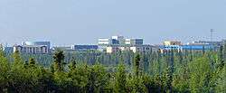
Buildings of central Inuvik from south of town | ||
| ||
 Inuvik  Inuvik | ||
| Coordinates: 68°21′42″N 133°43′50″W / 68.36167°N 133.73056°WCoordinates: 68°21′42″N 133°43′50″W / 68.36167°N 133.73056°W | ||
| Country | Canada | |
| Territory | Northwest Territories | |
| Region | Inuvik Region | |
| Constituency |
Inuvik Boot Lake Inuvik Twin Lakes | |
| Census division | Region 1 | |
| Settled | 1954 | |
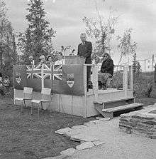
| Village | 1 April 1967 | |
| Town | 1 January 1970 [1] | |
| Government[2] | ||
| • Mayor | Jim McDonald | |
| • SAO | Grant Hood | |
| • MLA | Robert C. McLeod (Twin Lakes) | |
| • MLA | Alfred Moses (Boot Lake) | |
| • MP | Michael McLeod | |
| Area[3] | ||
| • Land | 62.48 km2 (24.12 sq mi) | |
| • Population centre[4] | 5.85 km2 (2.26 sq mi) | |
| Elevation | 15 m (49 ft) | |
| Highest elevation | 68 m (223 ft) | |
| Lowest elevation | 10 m (30 ft) | |
| Population (2006)[3] | ||
| • Total | 3,463 | |
| • Density | 55.4/km2 (143/sq mi) | |
| • Population centre[4] | 3,403 | |
| • Population centre density | 581.4/km2 (1,506/sq mi) | |
| Time zone | Mountain (MST) (UTC−7) | |
| • Summer (DST) | MDT (UTC−6) | |
| Canadian Postal code | X0E 0T0 | |
| Area code(s) | 867 | |
| Telephone exchange | 678/777 (777 was previously (403) 979) | |
| - Living cost | 147.5A | |
| - Food price index | 149.8B | |
| Highways | Dempster Highway | |
| Waterways | Mackenzie River | |
| Climate | Dfc | |
| Website |
www | |
|
Sources: Department of Municipal and Community Affairs,[5] Prince of Wales Northern Heritage Centre,[6] Canada Flight Supplement[7] ^A 2009 figure based on Edmonton = 100[8] ^B 2010 figure based on Yellowknife = 100[8] | ||

Inuvik /ᵻˈnuːvɪk/ (place of man) is a town in the Northwest Territories of Canada and is the administrative centre for the Inuvik Region.
The population as of the 2011 Census was 3,484,[3] a decrease of 0.6% from the 2006 Census. The two previous census counts show wide fluctuations due to economic conditions: 2,894 in 2001 and 3,296 in 1996.[9][10] In 2012 the Government of the Northwest Territories reported that the population was 3,321 with an average yearly growth rate of 0.2% from 2001.[8]
History
Inuvik was conceived in 1953 as a replacement administrative centre for the hamlet of Aklavik on the west of the Mackenzie Delta, as the latter was prone to flooding and had no room for expansion. Initially called "New Aklavik", it was renamed Inuvik in 1958. The school was built in 1959 and the hospital, government offices and staff residences in 1960, when people began to live in the community: Inuvialuit, Dene and Métis.
Naval Radio Station (NRS) Inuvik, callsign CFV, was commissioned on 10 September 1963 after operations had been successfully transferred from NRS Aklavik. Station CFV was part of the SUPRAD (Supplementary Radio) network of intercept and direction finding stations.
CFS Inuvik closed on 1 April 1986 and the site was transferred to the Dept. of Transport for use as a telecommunications station. Nothing remains of CFS Inuvik today. Even now, many people of all backgrounds still lament its closing. The Navy Operations base at the end of Navy Road was completely dismantled and removed.
Inuvik achieved village status in 1967 and became a full town in 1979 with an elected mayor and council. In 1979, with the completion of the Dempster Highway, Inuvik became connected to Canada's highway system, and simultaneously the most northerly town to which one could drive in the summer months — although an ice road through the Mackenzie River delta connects the town to Tuktoyaktuk, on the coast of the Arctic Ocean, and Aklavik, in the winter, and an all-weather road connecting Inuvik and Tuktoyaktuk is currently under construction.
Between 1971 and 1990, the town's economy was supported by the local Canadian Forces Station, CFS Inuvik, (originally a Naval Radio Station, later a communications research/signals intercept facility[11]) and by petrochemical companies exploring the Mackenzie Valley and the Beaufort Sea for petroleum. This all collapsed in 1990 for a variety of reasons, including disappearing government subsidies, local resistance to petroleum exploration, and low international oil prices.
On 10 February 2010, the Google Street View imaging service uploaded images of most Inuvik streets.[12]
Demographics
| Historical population | ||
|---|---|---|
| Year | Pop. | ±% |
| 1996 | 3,461 | — |
| 1997 | 3,361 | −2.9% |
| 1998 | 3,313 | −1.4% |
| 1999 | 3,317 | +0.1% |
| 2000 | 3,324 | +0.2% |
| 2001 | 3,395 | +2.1% |
| 2002 | 3,550 | +4.6% |
| 2003 | 3,571 | +0.6% |
| 2004 | 3,628 | +1.6% |
| 2005 | 3,657 | +0.8% |
| 2006 | 3,651 | −0.2% |
| 2007 | 3,600 | −1.4% |
| 2008 | 3,566 | −0.9% |
| 2009 | 3,564 | −0.1% |
| 2010 | 3,544 | −0.6% |
| 2011 | 3,463 | −2.3% |
| 2012 | 3,321 | −4.1% |
| Sources: NWT Bureau of Statistics (2001–2012)[8] | ||
- Population
- 3,484 in 2006
- Breakdown
- Inuvialuit (predominantly Uummarmiut), 38.9%; First Nations, 18.4%; Métis, 4.7%; other Aboriginal, 1.2%; non-native, 36.7%[13]
The main language spoken in Inuvik is English, though schools teach and a handful of local people still speak Inuvialuktun, and Gwich’in. Local CBC Radio broadcasts an hour of programming a day in each of these languages.[14]
There are also about 100 Muslims, most of whom came there for economic opportunities. A small mosque (dubbed "Little mosque on the tundra" in reference to the CBC show Little Mosque on the Prairie) was established in 2010.[15]
Geography
Inuvik is located on the East Channel of the Mackenzie Delta, approximately 100 km (60 mi) from the Arctic Ocean and approximately 200 km (120 mi) north of the Arctic Circle.
Due to its northern location, Inuvik experiences an average of 56 days of continuous sunlight every summer and 30 days of polar night every winter.
Transportation
Access is via the Dempster Highway for the majority of the year. The highway relies on ferries and ice bridges to get across the rivers. It is thus closed during the time of freeze-up (roughly late-October to mid-December), for ice to form and allow ice bridges, and thaw (roughly mid-May to mid-June) to allow the ferry to run. At these times, there is air access only.
The main airport is Inuvik (Mike Zubko) Airport and there is a general aviation airport, Inuvik/Shell Lake Water Aerodrome.
When the Mackenzie River is ice-free, Northern Transportation Company Limited provides a commercial barge service from Hay River, on Great Slave Lake to the regional terminal in Inuvik. The annual sealift moves supplies as far east as Taloyoak, Nunavut and west to Barrow, Alaska.[16]
A distinct feature of Inuvik is the use of "utilidors" – above-ground utility conduits carrying water and sewage – which are covered by corrugated steel. They run throughout town connecting most buildings, and as a result there are many small bridges and underpasses. The utilidors are necessary because of the permafrost underlying the town.
Another feature is an inukhuk placed outside the Mackenzie Hotel, which was rebuilt in 2006.
A great majority of roads are paved, and there are both concrete and metal-grill sidewalks alongside the roads.
Climate
Inuvik has a subarctic climate (Köppen Dfc). Summers are typically wetter and cool, with temperatures varying wildly throughout the months due to its peculiar location near the cold Arctic Ocean. The average hottest month of the year, July, has a mean high of 19.5 °C (67.1 °F) and mean low of 8.6 °C (47.5 °F). Unlike many other North American continental climates, Inuvik warms up very quickly during the months of May and June due to the rapidly increasing day length; June is a warmer month than August. Seasonal transitions are extremely short, with mean daily temperatures rising or falling as fast as 0.5 °C (0.9 °F) per day. Winters are long and extremely frigid; the coldest month of the year, January, having a mean high of −22.8 °C (−9.0 °F) and a mean low of −31.0 °C (−23.8 °F). Freezing temperatures can occur any month of the year. Inuvik has a great variation of temperatures during the year, usually peaking below −40 °C (−40 °F) in the winter and above 30 °C (86 °F) in the summer.[17] The highest temperature ever recorded in Inuvik was 32.8 °C (91 °F) on 17 June 1999 and 20 July 2001.[17] The coldest temperature ever recorded was −56.7 °C (−70 °F) on 4 February 1968.[17]
Snow that falls from October onward usually stays until the spring thaw in mid-May. By March, the median snow depth has reached its greatest, about 56.2 cm (22.1 in).[17]
| Climate data for Inuvik (Mike Zubko Airport), 1981–2010 normals, extremes 1957–present | |||||||||||||
|---|---|---|---|---|---|---|---|---|---|---|---|---|---|
| Month | Jan | Feb | Mar | Apr | May | Jun | Jul | Aug | Sep | Oct | Nov | Dec | Year |
| Record high °C (°F) | 7.1 (44.8) |
5.2 (41.4) |
6.1 (43) |
15.3 (59.5) |
30.4 (86.7) |
32.8 (91) |
32.8 (91) |
32.5 (90.5) |
26.2 (79.2) |
20.9 (69.6) |
10.6 (51.1) |
5.0 (41) |
32.8 (91) |
| Average high °C (°F) | −22.8 (−9) |
−20.9 (−5.6) |
−16.8 (1.8) |
−6.3 (20.7) |
5.2 (41.4) |
17.7 (63.9) |
19.5 (67.1) |
16.0 (60.8) |
7.9 (46.2) |
−4.3 (24.3) |
−17.1 (1.2) |
−20.0 (−4) |
−3.5 (25.7) |
| Daily mean °C (°F) | −26.9 (−16.4) |
−25.5 (−13.9) |
−22.3 (−8.1) |
−11.8 (10.8) |
0.4 (32.7) |
11.6 (52.9) |
14.1 (57.4) |
11.0 (51.8) |
3.9 (39) |
−7.6 (18.3) |
−21.1 (−6) |
−24.1 (−11.4) |
−8.2 (17.2) |
| Average low °C (°F) | −31.0 (−23.8) |
−30.1 (−22.2) |
−27.7 (−17.9) |
−17.4 (0.7) |
−4.5 (23.9) |
5.5 (41.9) |
8.6 (47.5) |
5.9 (42.6) |
−0.1 (31.8) |
−10.9 (12.4) |
−25.0 (−13) |
−28.2 (−18.8) |
−12.9 (8.8) |
| Record low °C (°F) | −54.4 (−65.9) |
−56.7 (−70.1) |
−50.6 (−59.1) |
−46.1 (−51) |
−27.8 (−18) |
−6.1 (21) |
−3.3 (26.1) |
−6.1 (21) |
−20.1 (−4.2) |
−35.0 (−31) |
−46.1 (−51) |
−50.0 (−58) |
−56.7 (−70.1) |
| Average precipitation mm (inches) | 12.5 (0.492) |
13.1 (0.516) |
11.9 (0.469) |
9.8 (0.386) |
17.3 (0.681) |
17.3 (0.681) |
35.0 (1.378) |
39.4 (1.551) |
29.3 (1.154) |
24.4 (0.961) |
16.0 (0.63) |
14.8 (0.583) |
240.6 (9.472) |
| Average rainfall mm (inches) | 0.1 (0.004) |
0.0 (0) |
0.0 (0) |
0.6 (0.024) |
5.9 (0.232) |
15.5 (0.61) |
35.0 (1.378) |
36.4 (1.433) |
20.3 (0.799) |
0.9 (0.035) |
0.0 (0) |
0.0 (0) |
114.5 (4.508) |
| Average snowfall cm (inches) | 15.4 (6.06) |
16.4 (6.46) |
14.8 (5.83) |
11.7 (4.61) |
14.2 (5.59) |
1.9 (0.75) |
0.0 (0) |
3.1 (1.22) |
10.4 (4.09) |
30.1 (11.85) |
21.3 (8.39) |
19.4 (7.64) |
158.6 (62.44) |
| Average precipitation days (≥ 0.2 mm) | 9.9 | 10.9 | 11.2 | 7.6 | 7.6 | 8.1 | 11.6 | 14.4 | 13.0 | 13.6 | 11.7 | 10.3 | 129.9 |
| Average rainy days (≥ 0.2 mm) | 0.1 | 0.1 | 0.1 | 0.3 | 2.5 | 7.1 | 10.8 | 13.9 | 8.9 | 1.0 | 0.0 | 0.1 | 44.7 |
| Average snowy days (≥ 0.2 cm) | 10.3 | 11.6 | 11.8 | 8.0 | 6.2 | 1.4 | 0.1 | 1.3 | 5.1 | 14.1 | 12.1 | 11.2 | 93.0 |
| Average relative humidity (%) (at 1500) | 67.3 | 65.4 | 58.0 | 59.3 | 59.9 | 49.3 | 56.3 | 63.2 | 68.8 | 78.6 | 74.0 | 69.7 | 64.2 |
| Mean monthly sunshine hours | 7.3 | 65.2 | 174.1 | 248.7 | 295.0 | 375.1 | 339.8 | 216.2 | 109.4 | 50.2 | 17.8 | 0.0 | 1,898.8 |
| Source: Environment Canada (Sunshine 1951–1980)[17][18][19][20] | |||||||||||||
Tourism
Famous attractions
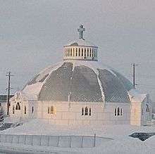
Inuvik's Our Lady Of Victory Church, often called Igloo Church, is a famous landmark in the region. It is the most-photographed building in the town .
Inuvik has North America's northernmost mosque, which opened in November 2010 after being built in Winnipeg and moved 4,000 km (2,500 mi) by truck and barge.[21] Some media reports have mistakenly called the mosque "the world's northernmost mosque", but in fact mosques in Norilsk, Russia, and Tromsø, Norway, are both slightly farther north than Inuvik.[22][23]
Annual events of note
The Great Northern Arts Festival[24] has been held annually for 10 days in the middle of July since 1989. The Festival has hosted over 1800 artists from across Canada's north, and from as far away as Japan and Australia over 22 years and is the largest annual tourism event in the Beaufort Delta. Featuring on-site demonstrations, 50+ arts workshops, a 3500-piece gallery, an outdoor carving village, an interactive artist studio zone, nightly cultural performances, northern film screenings, family activities and an Arctic fashion show, the Festival attracts visitors from around the world to travel the Dempster Highway to visit Inuvik and the Inuvialuit and Gwich'in Settlement Regions.
The annual Sunrise Festival happens on the second weekend of the new year, when the sun finally breaks the horizon after about thirty days of darkness. The Festival is an all-day community event highlighted by dog-sled races, a long-program fireworks show and community bonfire. This Festival was highlighted in the award-winning[25] 2010 national Tropicana Orange Juice commercial Arctic Sun.[26]
Inuvik celebrates the Muskrat Jamboree each year in late March or early April. Started in 1957, the event brings together thousands of people to participate in traditional games, watch the dog-sled and snowmobile races and dance (jig) the night away in town. Most events are held on the Mackenzie River where several community groups operate concessions in stove-heated traditional McPherson tents, preparing hot soup, bannock, baked goods, coffee, Labrador tea, hot chocolate and other traditional refreshments. Many participants and spectators wear traditional clothing and often local artisans will have something to sell. In conjunction with the Muskrat Jamboree, the Town of Inuvik hosts the annual Muskrat Cup 3-on-3 Pond Hockey Tournament on the frozen Mackenzie River, the world's most northerly cash tournament.
The weekend closest to the summer solistice (21 June) each year features the Midnight Sun Fun Run, a 5K, 10K and Half-Marathon that starts at midnight under the blazing 24-hours of sunlight experienced for 50+ days each summer in Inuvik. Runners from around the world make their way North to participate in this unique event under the midnight sun.
Facilities

A new hospital opened in early 2003, providing service to an area extending from Sachs Harbour on Banks Island, to Ulukhaktok on Victoria Island, and from Paulatuk into the Sahtu Region including Norman Wells, Tulit'a, Deline, Fort Good Hope, and Colville Lake.
The Midnight Sun Complex, a stage-built multi-use facility, was completed in 2006. Featuring the Roy 'Sugloo' Ipana Memorial Arena, with an NHL-sized ice surface; the Inuvik Curling Club with 3 sheets and a well-situated licensed lounge/viewing area; the Inuvik Pool, an award-winning Class B recreational pool with lane swimming, waterpark features including a two-story waterslide, hot tub, sauna and steam room; two squash courts; a multi-use community hall with stage; on-site business centre/production office; full building wireless; video-conferencing facility; on-site catering/kitchen; and meeting rooms for groups of 5 to 500. At full-building use, the Complex can host conferences, conventions and trade shows with up to 1200 delegates/exhibitors.[28]
The community has a state-of-the-art school called East 3. The construction budget for the school exceeded $110 million, and it features modern technologies such as 'smartboards' and videoconferencing facilities as well as a large gym.
Media
The town is served by the Inuvik Drum, a community newspaper published weekly by Northern News Services.
Television
| OTA channel | Call sign | Network | Notes |
|---|---|---|---|
| 13 (VHF) | CH4221 | Aboriginal Peoples Television Network |
Inuvik was previously served by CHAK-TV, VHF channel 6, a CBC North television repeater of CFYK-DT (Yellowknife); that station closed down on 31 July 2012 due to budget cuts affecting the CBC.[29][30]
Radio
| Frequency | Call sign | Branding | Format | Owner | Notes |
|---|---|---|---|---|---|
| AM 860 | CHAK | CBC Radio One | Talk radio, public radio | Canadian Broadcasting Corporation | Part of CBC North; broadcasts programming in English, Gwich’in, and Inuvialuktun |
| FM 98.7 | CKRW-FM-2 | The Rush | Hot adult contemporary | Klondike Broadcasting | Rebroadcaster of CKRW-FM (Whitehorse) |
| FM 101.9 | VF2082 | CKLB Radio: The Voice of Denendeh | Community radio | Native Communications Society of the Northwest Territories | First Nations community radio; rebroadcaster of CKLB-FM (Yellowknife) |
Communications
Landline telephone service is provided by Northwestel, and cellular service by ICE Wireless. Cable television is also offered in Inuvik by New North Networks.
Planetary nomenclature
In 1988, the International Astronomical Union's Working Group for Planetary System Nomenclature (IAU/WGPSN) officially adopted the name Inuvik for a crater on Mars, at 78.7° north latitude and 28.6° west longitude. The crater's diameter is 20.5 km (12.7 mi).[31]
Notable people
- Leona Aglukkaq, former member of Parliament for the electoral district of Nunavut and former Minister of Health
- Roger Allen, former member of the Legislative Assembly of the Northwest Territories
- Zac Boyer, former National Hockey League right winger
- Tom Butters, former member of the Legislative Assembly of the Northwest Territories
- Jason Elliott, former professional ice hockey player
- Fred Koe, former member of the Legislative Assembly of the Northwest Territories
- Floyd Roland, former Mayor of Inuvik and former Premier and member of the Legislative Assembly of the Northwest Territories
- Eric Schweig, Inuvialuit/Chippewa/Dene actor
See also
References
- ↑ http://www.inuvik.ca/en/discovering-inuvik/History.asp
- ↑ Town of Inuvik. "Community Profile". Retrieved 2008-03-13.
- 1 2 3 "Census Profile | Inuvik, T Northwest Territories (Census subdivision)". www12.statcan.gc.ca. Retrieved 2014-12-31.
- 1 2 "Census Profile | Inuvik Northwest Territories (Population centre)". www12.statcan.gc.ca. Retrieved 2014-12-31.
- ↑ "NWT Communities - Inuvik". Government of the Northwest Territories: Department of Municipal and Community Affairs. Retrieved {{{3}}}. Check date values in:
|access-date=(help) - ↑ "Northwest Territories Official Community Names and Pronunciation Guide". Prince of Wales Northern Heritage Centre. Yellowknife: Education, Culture and Employment, Government of the Northwest Territories. Archived from the original on 2016-01-13. Retrieved 2016-01-13.
- ↑ Canada Flight Supplement. Effective 0901Z 15 September 2016 to 0901Z 10 November 2016
- 1 2 3 4 Inuvik - Statistical Profile at the GNWT
- ↑ "2001 Community Profiles | 2001 Canada Census". www12.statcan.ca. Retrieved 2014-12-31.
- ↑ "1996 Census of Canada: Electronic Area Profiles". www12.statcan.ca. Retrieved 2014-12-31.
- ↑ Proc, Jerry (October 2007). "Inuvik". jproc.ca. Retrieved 2014-12-31.
- ↑ Google Maps @ Inuvik, NT, Canada Move to street views to find photos dated August 2009.
- ↑ "Aboriginal Population Profile from the 2006 Census, Statistics Canada - Census Subdivision". www12.statcan.ca. Retrieved 2014-12-31.
- ↑ "Legislative Assembly of the Northwest Territories, Inuvik". web.archive.org. Archived from the original on 20 February 2012. Retrieved 2014-12-31.
- ↑ "Little mosque on the tundra | Toronto Star". thestar.com. Retrieved 2014-12-31.
- ↑ NTCL services
- 1 2 3 4 5 "Inuvik A". Canadian Climate Normals 1981–2010. Environment Canada. Climate ID: 2202570. Retrieved 2014-01-09.
- ↑ "Daily Data Report for January 2009". Canadian Climate Data. Environment Canada. Climate ID: 2202575. Retrieved 19 July 2016.
- ↑ "Daily Data Report for April 2009". Canadian Climate Data. Environment Canada. Climate ID: 2202575. Retrieved 19 July 2016.
- ↑ "Daily Data Report for May 2010". Canadian Climate Data. Environment Canada. Climate ID: 2202575. Retrieved 19 July 2016.
- ↑ CBC News Article on the World's northernmost mosque
- ↑ "Alnor facts Tromsø". alnor.no. Retrieved 2014-12-31.
- ↑ "Arctic Muslims | The St. Petersburg Times | The leading English-language newspaper in St. Petersburg". sptimes.ru. Retrieved 2014-12-31.
- ↑ "Great Northern Arts Festival". gnaf.org. Retrieved 2014-12-31.
- ↑ "Cannes Lions 2010 Winners Film Lions". coloribus.com. Retrieved 2014-12-31.
- ↑ "Tropicana Juice: "Arctic Sun" TV Commercial by BBDO Toronto Canada". coloribus.com. Retrieved 2014-12-31.
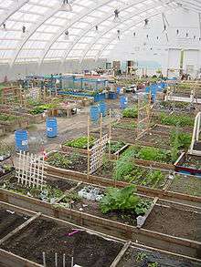
- ↑ "Inuvik Community Greenhouse".
- ↑ "Town of Inuvik | Go beyond the Arctic Circle | Town of Inuvik". inuvik.ca. Retrieved 2014-12-31.
- ↑ "Speaking notes for Hubert T. Lacroix regarding measures announced in the context of the Deficit Reduction Action Plan". cbc.radio-canada.ca. Retrieved 2014-12-31.
- ↑ "Broadcasting Decision CRTC 2012-384, July 17, 2012.". crtc.gc.ca. Retrieved 2014-12-31.
- ↑ "USGS Map MC-01 of the Mare Boreum Region of the planet Mars showing INUVIK Crater" (PDF). planetarynames.wr.usgs.gov. Retrieved 2014-12-31.
External links
| Wikimedia Commons has media related to Inuvik. |
| Wikivoyage has a travel guide for Inuvik. |
- Town of Inuvik Web Site
- Inuvik at DMOZ
- Dempster Highway & Inuvik roadtrip article on the Economist's More Intelligent Life website
| |||||||||||||||||||||||||||||||||||||||||||||||||||||||||||||||||||||||||||||||||||||||||||