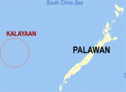
Kalayaan, Palawan
| Kalayaan | ||
|---|---|---|
| Municipality | ||
| ||
 Map of Palawan showing the location of Kalayaan | ||
.svg.png) Kalayaan Location within the Philippines | ||
| Coordinates: 11°03′N 114°17′E / 11.050°N 114.283°ECoordinates: 11°03′N 114°17′E / 11.050°N 114.283°E | ||
| Country |
| |
| Region | MIMAROPA (Region IV-B) | |
| Province | Palawan | |
| District | 1st District of Palawan | |
| Founded | June 11, 1978 | |
| Barangays | 1 | |
| Government[1] | ||
| • Mayor | Eugenio B. Bito-onon Jr. | |
| Area[2] | ||
| • Total | 290 km2 (110 sq mi) | |
| • Land | 0.79 km2 (0.31 sq mi) | |
| Population (2010)[3] | ||
| • Total | 222 | |
| • Density | 0.77/km2 (2.0/sq mi) | |
| Time zone | PST (UTC+8) | |
| ZIP code | 5322 | |
| Income class | 5th class; rural | |
| Website | kalayaanpalawan.gov.ph | |

Kalayaan is a fifth class municipality in the Philippine province of Palawan in the Spratly archipelago, situated within the South China Sea.
Kalayaan municipality, which includes the Pagasa (Thitu) island, is 280 nautical miles north-west of Puerto Princesa and 932 kilometres (579 mi) south-west of Metro Manila. According to the 2010 census,[3] it has a population of 222 people consisting of a single barangay located on Pag-asa Island, which also serves as the seat of the municipal government. It is the smallest municipality in the Philippines. Kalayaan's annual budget is 47 million pesos (about $1.1 million).[4]
Pag-asa Island has a dilapidated airstrip, a 5-bed lying-in clinic, and a small elementary school.[5]
Once a strictly a military installation, Pag-asa was opened to civilian settlement in 2002.[5][6]
History
There are records of the island having been inhabited, at various times in history, by the Chinese and by people from the Champa Kingdom of Vietnam, and during the second world war, French Indochina and Imperial Japanese troops.[7][8][9] However, there were no large settlements on these islands till 1956, when Filipino lawyer / businessman / adventurer / fishing magnate Tomas Cloma decided to "claim" a part of Spratly islands as his own, naming it the "Free Territory of Freedomland".[10]
In 1946, Vice President Elpidio Quirino reiterated the Southern Islands, the forerunner name for Kalayaan, as part of the Philippines.
In 1947, Tomas Cloma "discovered" a group of several uninhabited and unoccupied islands/islets in the vastness of the Luzon Sea.
On May 11, 1956, together with forty men, Tomas Cloma took formal possession of the islands, lying some 380 miles west of the southern end of Palawan and named them the "Free Territory of Freedomland". Four days later Cloma issued and posted copies of his "Notice to the Whole World" on each of the islands as "a decisive manifestation of unwavering claim over the territory".
On May 31, 1956, Cloma declared the establishment of the Free Territory of Freedomland, ten days after he sent his second representation to the Secretary of Foreign Affairs, informing the latter that the territory claimed was named "Freedomland".
On July 6, 1956, Cloma declared to the whole world his claim and the establishment of a separate government for the "Free Territory of Freedomland" with its capital on Flat Island (Patag Island). His declaration was met with violent and unfriendly reactions from several neighboring countries especially the Republic of China (ROC; on Taiwan since 1949) when on September 24, 1956 it effectively garrisoned the nearby island of Itu Aba and intercepted Cloma's men and vessels found within its immediate waters.
In 1974, Cloma ceded his rights over the islands for one peso, after being imprisoned by Ferdinand Marcos.[11]
Presidential Decree 1596
President Ferdinand E. Marcos created the Municipality of Kalayaan by signing PD 1596[12] into law on June 11, 1978. This established what the document described as "a distinct and separate municipality of the Province of Palawan".
PD 1596 defined the boundaries of the municipality as follows:
From a point [on the Philippine Treaty Limits] at latitude 7º40' North and longitude 116º00' East of Greenwich, thence due West along the parallel of 7º40' N to its intersection with the meridian of longitude 112º10' E, thence due north along the meridian of 112º10' E to its intersection with the parallel of 9º00' N, thence north-eastward to the intersection of parallel of 12º00' N with the meridian of longitude 114º30' E, thence, due East along the parallel of 12º00' N to its intersection with the meridian of 118º00' E, thence, due South along the meridian of longitude 118º00' E to its intersection with the parallel of 10º00' N, thence Southwestwards to the point of beginning at 7º40' N, latitude and 116º00' E longitude.
i.e. 7º40'N 116º00'E; west to 7º40'N 112º10'E; north to 9º00'N 112º10'E; NE to 12º00'N 114º30'E; east to 12º00'N 118º00'E; south to 10º00'N 118º00'E; SW to 7º40'N 116º00'E.
Republic Act 9522
Republic Act 9522 of 2009,[13] which defined the archipelagic baselines of the Philippines, claimed sovereignty over the Kalayaan Island Group under Section 2, sub-paragraph A which described the territory as a "Regime of Islands"—a concept defined in the United Nation Convention on Law of the Sea for similar bodies of land.[14]
Rival claims
In addition to the Philippines, China, Taiwan, Vietnam claim all claim the Spratley Archipelago either as a whole or in part. The Philippines occupies 10 reefs and islands. The People's Republic of China presently occupies seven (7) reefs. The Republic of China (Taiwan)'s solitary island is the largest in the archipelago at approximately 43 hectares. Vietnam occupies 21 islets and reefs. Malaysia claims 7 reefs including Layang Layang which currently hosts a naval base and a diving resort.[15] Interest in the archipelago was reportedly triggered by Cloma’s declaration and subsequent assertion by the Philippines.
In March 1976, President Marcos issued the Letter of Instruction (LOI) No.1-76 organizing the AFP Western Command based in Palawan in response to the heightening conflict of interest in the region and to abate any untoward incident.
Geography
| Part of a series on the |
| Spratly Islands |
|---|
 Spratly Islands military occupations map |
| Related articles |
| Confrontations |
| Military occupations |
|
|
The Municipality of Kalayaan is located in the western section of the Province of Palawan. It consists of one barangay, Pag-Asa, and currently exercises jurisdiction over eight islets (three of which are cays) and two reefs, with an aggregate land area of approximately 79 hectares. They are:
| Feature name | Area | Type | |
|---|---|---|---|
| Philippine | Internationally recognized | ||
| Pag-asa | Thitu | 32.7 hectares (81 acres) | Island |
| Likas | West York Island | 18.6 hectares (46 acres) | Island |
| Parola | Northeast Cay | 12.7 hectares (31 acres) | Island (Cay) |
| Lawak | Nanshan | 7.9 hectares (20 acres) | Island |
| Kota | Loaita | 6.45 hectares (15.9 acres) | Island |
| Patag | Flat | 0.57 hectares (1.4 acres) | Island (Cay) |
| Panata | Lankiam | 0.44 hectares (1.1 acres) | Island (Cay) |
| Balagtas | Irving | N/A | Reef |
| Ayungin | Second Thomas | N/A | Reef |
| Rizal | Commodore | N/A | Reef |
Topography
The islets that comprise the Municipality are generally flat. The highest ground elevation is approximately two (2) meters above sea level.
Demographics
| Population census of Kalayaan | ||
|---|---|---|
| Year | Pop. | ±% p.a. |
| 1990 | 50 | — |
| 1995 | 349 | +43.92% |
| 2000 | 223 | −9.16% |
| 2007 | 114 | −8.84% |
| 2010 | 222 | +27.45% |
| Source: National Statistics Office[3][16] | ||
Transportation
Rancudo Airfield
Pag-asa island hosts a 1,300 meter runway constructed in the early 70s on orders of MGEN Jose Rancudo, Commanding General of the Philippine Air Forces. In February 1992,[17] the Armed Forces of the Philippines named the runway "Rancudo Airfield" in honor of its architect.
Telecommunications
Smart Telecommunications established a cell site, connected to its main network via VSAT (Very Small Aperture Terminal), on the island in 2005 making normal GSM-based cellphone communication with the island possible. The first call on the system took place on June 12 at 5:18 PM between the mayor of the municipality at the time and a Smart Telecom executive. The company completed a maintenance visit to the cell site in 2011, thus ensuring continued operation of the facility.[18]
Environment
On June 8, 1982, Kota (Loaita) and Panata (Lankiam) islands were designated are marine turtle sanctuaries by the Ministry of National Resources (MNR) Administrative Order No.8.[19]
Politics

The first ever recorded election in Kalayaan during the post Marcos dictatorship was on January 30, 1980 where Mr. Aloner M. Heraldo was elected as the first Municipal Mayor.
But the Municipality of Kalayaan was after the Marcos regime created “demilitarized” on January 18, 1988 and the first appointed Mayor was Alejandro Rodriguez who was subsequently replaced by his appointed Vice-mayor Gaudencio R. Avencena.
The first free election in Kalayaan was held on May 11, 1992 synchronized election, where mostly young Municipal officers under the leadership of Hon. Mayor Gil D. Policarpio served for nine years, equivalent to three (3) terms from 1992-2001.
A new administration assumed office on July 2, 2001, when Mayor Rosendo L. Mantes won the election on May 14, 2001.
The current Mayor of Municipality of Kalayaan is Eugenio B. Bito-Onon Jr. He won his second term as Mayor on May 13, 2013[20][21]
See also
- Sansha, Hainan, China
- Trường Sa, Khánh Hòa, Vietnam
- Philippines and the Spratly Islands
- Spratly Islands dispute
- Free Territory of Freedomland
- Territorial disputes in the South China Sea
References
- ↑ "Municipalities". Quezon City, Philippines: Department of the Interior and Local Government. Archived from the original on 25 January 2013. Retrieved 23 November 2012.
- ↑ "Province: PALAWAN". PSGC Interactive. Makati City, Philippines: National Statistical Coordination Board. Archived from the original on 14 November 2012. Retrieved 23 November 2012.
- 1 2 3 "Total Population by Province, City, Municipality and Barangay: as of May 1, 2010" (PDF). 2010 Census of Population and Housing. National Statistics Office. Archived from the original (PDF) on 15 November 2012. Retrieved 22 November 2012.
- ↑ "Countries Around South China Sea Bolster Claims With Island Outposts".
- 1 2 Esmaquel II, Paterno (19 July 2014). "PH town 'no match' vs China's Sansha City". Rappler. Retrieved 21 March 2014.
- ↑ Angelina G. Goloy "Promise of Pag-asa", Manila Standard, Manila, 22 August 2005. Retrieved on 10 October 2005.
- ↑ "Timeline". History of the Spratlys. www.spratlys.org. Retrieved 21 March 2014.
- ↑ Chemillier-Gendreau, Monique (2000). Sovereignty Over the Paracel and Spratly Islands. Kluwer Law International. ISBN 9041113819.
- ↑ China Sea pilot, Volume 1 (8th Edition). Taunton: UKHO - United Kingdom Hydrographic Office. 2010. Retrieved 2014-06-26.
- ↑ "China and Philippines: The reasons why a battle for Zhongye (Pag-asa) Island seems unavoidable". China Daily Mail. 13 January 2014. Retrieved 21 March 2014.
- ↑ Womack, Brantly. China and Vietnam. Cambridge University Press. p. 218 footnote 18. Retrieved March 4, 2012.
- ↑ "PD 1596". Pasig City, Philippines: Chan Robles Virtual Law Library. Retrieved 17 August 2013.
- ↑ "Republic Act 9522", Congress of the Republic of the Philippines, Manila, 10 March 2009. Retrieved on 24 August 2013.
- ↑ "UNCLOS Part VIII", United Nations, New York, 10 December 1982. Retrieved on 24 August 2013.
- ↑ "Layang Layang". Avillon. Retrieved 18 August 2013.
- ↑ "Province of Palawan". Municipality Population Data. LWUA Research Division. Retrieved 18 July 2013.
- ↑ "Kalayaan Chain of Islands". Philippine Military Academy Alumni Association. Retrieved 20 August 2013.
- ↑ "RP’s remotest town freed from isolation", Manila Bulletin, Manila, 13 June 2005. Retrieved on 23 May 2006.
- ↑ "PCP-LGU Kalayaan and AFP in Palawan". Philippine Clearing House Mechanism for Biodiversity. Retrieved 18 August 2013.
- ↑ "Chinese warship chases Kalayaan town boat carrying mayor-elect". Philippine Star. Retrieved 22 August 2013.
- ↑ A Game of Shark and Minnow, NY Times Magazine, 27 October 2013.
Further reading
- Dzurek, Daniel J.; Clive H. Schofield (1996). The Spratly Islands dispute: who's on first?. IBRU. ISBN 978-1-897643-23-5. Retrieved 2014-06-26.
External links
| Wikivoyage has a travel guide for Kalayaan. |
- Philippine Standard Geographic Code
- Philippine Census Information
- Local Governance Performance Management System
 |
Sansha / South China Sea | |
West Philippine Sea | |
| South China Sea | |
West Philippine Sea | ||
| ||||
| | ||||
| West Philippine Sea | Rizal |
Puerto Princesa (capital) | |
| Municipalities | |
| Highly urbanized city |
|