Iowa Highway 4
| ||||
|---|---|---|---|---|
|
Iowa 4 highlighted in red | ||||
| Route information | ||||
| Maintained by Iowa DOT | ||||
| Length: | 146.343 mi[1] (235.516 km) | |||
| Existed: | January 1, 1969 – present | |||
| History: | 1920–1968: Iowa 17 | |||
| Major junctions | ||||
| South end: |
| |||
| ||||
| North end: |
| |||
| Location | ||||
| Counties: | ||||
| Highway system | ||||
| ||||

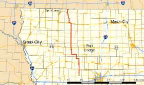
Iowa Highway 4 (Iowa 4) is a state highway which runs from north to south across the state of Iowa. It is 146 miles (235 km) long, beginning at an intersection with Iowa Highway 44 in Panora and ending at the Minnesota state line north of Estherville. It continues north as Minnesota State Highway 4. The route was created on January 1, 1969, when several route designations were changed to match other states' route numbers. Before 1969, Iowa 4 was known as Iowa 17.
Route description
Iowa Highway 4 begins at Panora at Iowa 44. It goes north and is briefly overlapped with Iowa Highway 141 north of Yale. It continues north until Jefferson, where it intersects U.S. Route 30 (US 30). It goes north, then turns west to enter Churdan, then turns north until meeting Iowa 175. At Iowa 175, the highway turns west, with Iowa 175, passing through Lohrville. It turns north west of Lohrville, and continues north through Rockwell City, where it intersects US 20.

After a short concurrency with US 20, Iowa 4 continues north, and intersects Iowa 7. They overlap through Pomeroy, then Iowa 4 goes north through Pocahontas, which is where it intersects Iowa 3. North of Pocahontas, Iowa 4 meets Iowa 10 east of Havelock before passing through Mallard. Iowa 4 then goes north into Emmetsburg, where it meets US 18.
Iowa 4 and US 18 continue west of Emmetsburg together, then Iowa 4 turns north to go through Graettinger. Iowa 4 then turns slightly northwesterly to go through Wallingford, before meeting Iowa 9 in Estherville. Iowa 4 then goes northeasterly out of Estherville before ending at the Minnesota border.
History
Iowa 4 was created on January 1, 1969, during an effort by the Iowa State Highway Commission (IHC) to renumber Iowa's state highways. The goal of the effort was to reduce confusion among drivers crossing into Iowa from other states by aligning Iowa's route numbers with their adjoining routes in other states.[2] However, most of the route on which Iowa 4 is now applied has been in the primary highway system since it was created in 1920.[3]
At its designation, Primary Road No. 17 was a much longer route than Iowa 4 is today. Primary Road No. 17 began in Albia at Primary Road Nos. 8 (now US 34) and 59 (now Iowa 5) and headed northwest through Knoxville and Des Moines. It continued west and north by passing through Adel and Perry before turning more northerly at Jefferson. It entered Rockwell City, Pocahontas, Emmetsburg, and Estherville. It ended at the intersection of Primary Road Nos. 4 (now US 71) and 9 in Spirit Lake.[3]
In 1926, when the U.S. Highway System was introduced, Iowa 17 was shortened on both ends. A service bulletin from the IHC in late 1925 listed Iowa 17 would begin in Jefferson and follow the same route to Estherville.[4] However, maps published the highway commission in 1927 show the route extended south to Adel ending at US 6.[5] By 1931, it had been extended north to the Minnesota state line along what was then Emmet County Road H (CR H).[6][7]
Ten years later, the southern end of the route shifted west to its current in end Panora, replacing Iowa 150 in its entirety. The sections that were duplicate routes with US 30, US 169, and Iowa 141 were removed, while the standalone section between Grand Junction and Perry became part of Iowa 144.[8] Over the next 28 years, sections of Iowa 17 were straightened and the paving of the route was completed.[9]
As of 2011, construction of a new four-lane expressway for US 20 has caused a portion of that route to be rerouted onto Iowa 4. The expressway begins eastbound at Iowa 4 and extends across the rest of the state to Dubuque.[10]
Major intersections
| County | Location | mi[1] | km | Destinations | Notes |
|---|---|---|---|---|---|
| Guthrie | Panora | 0.000 | 0.000 | ||
| Richland Township | 10.251 | 16.497 | Southern end of Iowa 141 overlap | ||
| 10.697 | 17.215 | Northern end of Iowa 141 overlap | |||
| Greene | Jefferson | 24.004 | 38.631 | ||
| Calhoun | Reading Township | 44.908 | 72.272 | Southern end of Iowa 175 overlap | |
| Calhoun Township | 53.789 | 86.565 | Northern end of Iowa 175 overlap | ||
| Twin Lakes Township | 67.449 | 108.549 | |||
| Butler–Sherman township line | 72.180 | 116.162 | Southern end of Iowa 7 overlap | ||
| Pocahontas | Bellville–Colfax township line | 77.106 | 124.090 | Northern end of Iowa 7 overlap | |
| Pocahontas | 87.078 | 140.138 | |||
| Havelock | 93.617 | 150.662 | |||
| Palo Alto | Emmetsburg | 113.358 | 182.432 | Southern end of US 18 overlap | |
| Emmetsburg Township | 118.026 | 189.944 | Northern end of US 18 overlap | ||
| Emmet | Estherville | 138.132 | 222.302 | ||
| Ellsworth Township | 146.343 | 235.516 | Continuation into Minnesota | ||
1.000 mi = 1.609 km; 1.000 km = 0.621 mi
| |||||
References
- 1 2 "2013 Volume of Traffic on the Primary Road System of Iowa" (PDF). Iowa Department of Transportation. January 1, 2013. Retrieved October 1, 2010.
- ↑ "New Iowa Map Goes on Sale". Telegraph-Herald. Dubuque, Iowa. January 14, 1969. Retrieved October 12, 2011.
- 1 2 Iowa State Highway Map (PDF) (Map). Iowa State Highway Commission. 1919. Retrieved October 12, 2011.
- ↑ Service Bulletin. Iowa State Highway Commission. XIII (10–11–12): 8. October–November–December 1925. Check date values in:
|date=(help); Missing or empty|title=(help) - ↑ Iowa State Highway Map (PDF) (Map). Iowa State Highway Commission. 1927. Retrieved October 12, 2011.
- ↑ Iowa State Highway Map (PDF) (Map). Iowa State Highway Commission. 1930. Retrieved October 12, 2011.
- ↑ Iowa State Highway Map (PDF) (Map). Iowa State Highway Commission. 1931. Retrieved October 12, 2011.
- ↑ Iowa State Highway Map (PDF) (Map). Iowa State Highway Commission. 1941. Retrieved October 12, 2011.
- ↑ Iowa State Highway Map (PDF) (Map). Iowa State Highway Commission. 1968. Retrieved October 12, 2011.
- ↑ Transportation Map (PDF) (Map). Iowa Department of Transportation. 2011. Retrieved October 12, 2011.
External links
- The Iowa Highways Page by Jason Hancock