Iowa Highway 5
| ||||
|---|---|---|---|---|
|
Iowa 5 highlighted in red | ||||
| Route information | ||||
| Maintained by Iowa DOT | ||||
| Length: | 103.540 mi[1] (166.631 km) | |||
| Existed: | January 1, 1969[2] – present | |||
| Major junctions | ||||
| South end: |
| |||
| ||||
| North end: |
| |||
| Location | ||||
| Counties: | ||||
| Highway system | ||||
| ||||

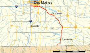
Iowa Highway 5 is a highway in southern Iowa. It is a north–south highway with a length of 105 miles (169 km). It is the northernmost segment of a three-state "Highway 5" also involving Missouri Route 5 and Arkansas Highway 5. Portions of the highway are freeway and expressway. It had previously been designated Iowa Highway 60. The southern terminus of Iowa Highway 5 is at the Missouri border southwest of Cincinnati. Its northern terminus is at Interstate 35 at West Des Moines.
Route description
Iowa Highway 5 begins at the Missouri border southwest of Cincinnati. It passes through Cincinnati, then turns north to go through Centerville, where it intersects Iowa Highway 2. It continues north through Moravia and intersects U.S. Highway 34 in Albia. Iowa 5 also intersects Iowa Highway 137 in Albia and turns northwest. It goes northwest through Lovilia and Hamilton before intersecting Iowa Highway 92 in Knoxville.
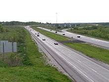
Iowa 5 and Iowa 92 then become a freeway bypass of Knoxville, bypassing Knoxville on its south side, intersecting Iowa Highway 14 on the bypass. After the bypass, Iowa 5 and Iowa 92 become an expressway. Iowa 5 then separates from Iowa 92 near Pleasantville. Iowa 5 then turns north, bypasses Pleasantville, and intersects Iowa Highway 316 northwest of Pleasantville. Iowa 5 continues northwest past Hartford and Carlisle, then intersects U.S. Highway 65. Iowa 5 then goes west as a freeway with U.S. 65 to an interchange with U.S. Highway 69, where U.S. 65 separates in Des Moines. Iowa 5 then continues west as a southeastern freeway bypass of Des Moines, intersecting Iowa Highway 28 at Norwalk and ends in West Des Moines at Interstate 35.
History
Primary Road 5 was designated in 1920 connecting Sioux City and Dubuque. In 1926, this route was truncated at Fort Dodge and at Le Mars and subsequently extended to Akron in 1929. From 1945 through 1962, when Iowa 5 was again truncated near Aurelia, Iowa 5 overlapped Iowa 3 for 60 miles (97 km).[3] This last section of Iowa 5 is now designated Iowa Highway 7.[2]
The current Iowa 5 was designated on January 1, 1969, along the southern portion Iowa Highway 60. It was renumbered to provide route number continuity with Missouri Route 5.[2] In 1978, a bypass of Knoxville was opened carrying Iowa 5 and Iowa Highway 92 around the southern edge of Knoxville.
In the Des Moines area, Iowa 5 had the same route along Army Post Road from 1969 until 1997, when sections of a southern bypass, completed in 2002, were opened.
Major intersections
| County | Location | mi[1] | km | Exit[4] | Destinations | Notes |
|---|---|---|---|---|---|---|
| Appanoose | Franklin Township | 0.000 | 0.000 | |||
| Centerville | 13.624 | 21.926 | ||||
| Monroe | Albia | 34.122 | 54.914 | |||
| 35.295 | 56.802 | |||||
| Marion | Knoxville | 60.290 | 97.027 | 60 | South end of IA 92 overlap | |
| 62.242 | 100.169 | 62 | ||||
| 64.549 | 103.882 | 64 | ||||
| Pleasant Grove Township | 71.348 | 114.823 | North end of IA 92 overlap | |||
| Warren | Richland Township | 78.304 | 126.018 | |||
| Polk | Allen Township | 89.873 | 144.637 | 72 | South end of US 65 overlap | |
| Warren | Des Moines | 92.501 | 148.866 | 70 | Signed as exits 70A (south) and 70B (north); north end of US 65 overlap | |
| 95.387 | 153.510 | 96 | ||||
| 96.555 | 155.390 | 97 | ||||
| Polk | West Des Moines | 98.582 | 158.652 | 99 | ||
| 100.809 | 162.236 | 101 | Southwest Connector | |||
| 102.261 | 164.573 | 102 | South 35th Street, Walnut Woods State Park | |||
| 103.540 | 166.631 | — | ||||
1.000 mi = 1.609 km; 1.000 km = 0.621 mi
| ||||||
References
- 1 2 "2009 Volume of Traffic on the Primary Road System of Iowa" (PDF). Iowa Department of Transportation. January 1, 2009. Retrieved January 9, 2011.
- 1 2 3 Hatfield, Richard (November 12, 1968). "Iowa's Highway Route Numbers Revised". Des Moines Tribune.
- ↑ Road and Reference Atlas (Map) (1947 ed.). 1:1,077,120. Rand McNally & Company. 1947. pp. 42–43.
- ↑ Transportation Map (PDF) (Map). Iowa Department of Transportation. 2011. Retrieved November 21, 2011.
External links
- The Iowa Highways Page by Jason Hancock