Jamaica, Iowa
| Jamaica, Iowa | |
|---|---|
| City | |
 | |
 Location of Jamaica, Iowa | |
| Coordinates: 41°51′N 94°18′W / 41.850°N 94.300°WCoordinates: 41°51′N 94°18′W / 41.850°N 94.300°W | |
| Country |
|
| State |
|
| County | Guthrie |
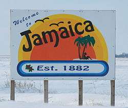
| Established | 1882 |
| Area[1] | |
| • Total | 0.46 sq mi (1.19 km2) |
| • Land | 0.46 sq mi (1.19 km2) |
| • Water | 0 sq mi (0 km2) |
| Elevation | 1,033 ft (315 m) |
| Population (2010)[2] | |
| • Total | 224 |
| • Estimate (2012[3]) | 221 |
| • Density | 487.0/sq mi (188.0/km2) |
| Time zone | Central (CST) (UTC-6) |
| • Summer (DST) | CDT (UTC-5) |
| ZIP code | 50128 |
| Area code(s) | 641 |
| FIPS code | 19-39225 |
| GNIS feature ID | 0457909 |
Jamaica is a city in Guthrie County, Iowa, United States. The population was 224 at the 2010 census. It is part of the Des Moines–West Des Moines Metropolitan Statistical Area.
History
Jamaica was platted in 1882.[4]
A local historian named Bruce F. Towne published a short book entitled "Bricks on the Chimney" which discusses the origins and history of Jamaica. Towne was a local grocery store owner for several decades, a business founded by his father in the early 1900s. In March 1921, Maylen M. Heater was Jamaica's first traffic victim when his car overturned just west of town. He was the vice president of his father's bank. On July 4, 1919 Clarence Kinney and his son Guy tragically drowned in the high waters of the Raccoon River near the old saw mill. In 1921 the local garage was destroyed by fire when a local resident thought his Model T was leaking gas. He crawled under the automobile and lit a match which resulted in an explosion. In the 1930s, the flu epidemic killed several local residents.
Geography
Jamaica is located at 41°51′N 94°18′W / 41.850°N 94.300°W (41.8465, -94.3074).[5]
According to the United States Census Bureau, the city has a total area of 0.46 square miles (1.19 km2), all of it land.[1]
Demographics

| Historical populations | ||
|---|---|---|
| Year | Pop. | ±% |
| 1910 | 379 | — |
| 1920 | 295 | −22.2% |
| 1930 | 311 | +5.4% |
| 1940 | 283 | −9.0% |
| 1950 | 303 | +7.1% |
| 1960 | 256 | −15.5% |
| 1970 | 271 | +5.9% |
| 1980 | 275 | +1.5% |
| 1990 | 232 | −15.6% |
| 2000 | 237 | +2.2% |
| 2010 | 224 | −5.5% |
| 2014 | 220 | −1.8% |
| 2015 | 219 | −0.5% |
| Source:"American FactFinder". United States Census Bureau. and Iowa Data Center Source: | ||
2010 census
As of the census[2] of 2010, there were 224 people, 97 households, and 57 families residing in the city. The population density was 487.0 inhabitants per square mile (188.0/km2). There were 109 housing units at an average density of 237.0 per square mile (91.5/km2). The racial makeup of the city was 95.1% White, 2.7% from other races, and 2.2% from two or more races. Hispanic or Latino of any race were 6.3% of the population.
There were 97 households of which 27.8% had children under the age of 18 living with them, 41.2% were married couples living together, 11.3% had a female householder with no husband present, 6.2% had a male householder with no wife present, and 41.2% were non-families. 37.1% of all households were made up of individuals and 18.6% had someone living alone who was 65 years of age or older. The average household size was 2.31 and the average family size was 3.11.
The median age in the city was 41.7 years. 24.6% of residents were under the age of 18; 6.6% were between the ages of 18 and 24; 22.8% were from 25 to 44; 28.5% were from 45 to 64; and 17.4% were 65 years of age or older. The gender makeup of the city was 47.8% male and 52.2% female.
2000 census
As of the census[7] of 2000, there were 237 people, 102 households, and 57 families residing in the city. The population density was 518.1 people per square mile (198.9/km²). There were 114 housing units at an average density of 249.2 per square mile (95.7/km²). The racial makeup of the city was 98.73% White, 1.27% from other races. Hispanic or Latino of any race were 1.27% of the population.
There were 102 households out of which 24.5% had children under the age of 18 living with them, 48.0% were married couples living together, 4.9% had a female householder with no husband present, and 44.1% were non-families. 36.3% of all households were made up of individuals and 17.6% had someone living alone who was 65 years of age or older. The average household size was 2.32 and the average family size was 3.16.
In the city the population was spread out with 24.5% under the age of 18, 7.6% from 18 to 24, 30.0% from 25 to 44, 21.1% from 45 to 64, and 16.9% who were 65 years of age or older. The median age was 38 years. For every 100 females there were 88.1 males. For every 100 females age 18 and over, there were 86.5 males.
The median income for a household in the city was $35,417, and the median income for a family was $41,875. Males had a median income of $27,917 versus $18,750 for females. The per capita income for the city was $18,850. About 8.8% of families and 14.5% of the population were below the poverty line, including 31.9% of those under the age of eighteen and 5.3% of those sixty five or over.
Economy
A 6,000-square-foot (560 m2) recording studio, Sound Farm, where Slipknot & The Envy Corps recorded their 2008 albums All Hope is Gone and Dwell, is located in Jamaica.[8][9]
Arts and culture
Near to Jamaica is an octagon barn built in 1881, one of seven in Iowa to be listed on the National Register of Historic Places. The metal band Slipknot filmed the music video for "Psychosocial" here.[10] They also recorded their fourth album All Hope Is Gone here.
Government
LaDonna Kennedy was elected mayor in 2015 and will serve until 2019.[11]
See also
References
- 1 2 "US Gazetteer files 2010". United States Census Bureau. Retrieved 2012-05-11.
- 1 2 "American FactFinder". United States Census Bureau. Retrieved 2012-05-11.
- ↑ "Population Estimates". United States Census Bureau. Retrieved 2013-05-23.
- ↑ History of Guthrie and Adair Counties, Iowa. Continental Historical Company. 1884. p. 695.
- ↑ "US Gazetteer files: 2010, 2000, and 1990". United States Census Bureau. 2011-02-12. Retrieved 2011-04-23.
- ↑ "Census of Population and Housing". Census.gov. Retrieved June 4, 2015.
- ↑ "American FactFinder". United States Census Bureau. Retrieved 2008-01-31.
- ↑ "Sound Farm Studio & Recording Environment: EQ Magazine: July 2007". EQ Magazine. 2007-07-01. Archived from the original on February 12, 2012. Retrieved 2009-01-18.
- ↑ Lawler, Joe (2008-08-20). "Slipknot brings it back home". Metromix. Retrieved 2009-01-18.
- ↑ Harris, Chris (2008-07-17). "Slipknot's Clown On 'Psychosocial' Video: 'Our Goal Has Always Been To Infect'". MTV. Retrieved 2008-07-18.
- ↑ "November 3, 2015, City Elections: Official Results" (PDF). Guthrie County website. December 8, 2015. Retrieved December 9, 2015.
| Wikimedia Commons has media related to Jamaica, Iowa. |
Municipalities and communities of Guthrie County, Iowa, United States | ||
|---|---|---|
| Cities | ||
| CDPs | ||
| Unincorporated communities | ||
| Footnotes | ‡This populated place also has portions in an adjacent county or counties | |