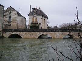
Is-sur-Tille
| Is-sur-Tille | ||
|---|---|---|
 | ||
| ||
 Is-sur-Tille | ||
|
Location within Bourgogne-Franche-Comté region  Is-sur-Tille | ||
| Coordinates: 47°31′18″N 5°06′58″E / 47.5217°N 5.1161°ECoordinates: 47°31′18″N 5°06′58″E / 47.5217°N 5.1161°E | ||
| Country | France | |
| Region | Bourgogne-Franche-Comté | |
| Department | Côte-d'Or | |
| Arrondissement | Dijon | |
| Canton | Is-sur-Tille | |
| Government | ||
| • Mayor (2008–2014) | Michel Maillot | |
| Area1 | 22.53 km2 (8.70 sq mi) | |
| Population (2008)2 | 3,882 | |
| • Density | 170/km2 (450/sq mi) | |
| Time zone | CET (UTC+1) | |
| • Summer (DST) | CEST (UTC+2) | |
| INSEE/Postal code | 21317 / 21120 | |
| Elevation |
262–408 m (860–1,339 ft) (avg. 284 m or 932 ft) | |
|
1 French Land Register data, which excludes lakes, ponds, glaciers > 1 km² (0.386 sq mi or 247 acres) and river estuaries. 2 Population without double counting: residents of multiple communes (e.g., students and military personnel) only counted once. | ||
.svg.png)
Is-sur-Tille is a commune in the Côte-d'Or department of Bourgogne-Franche-Comté France.
Geography
Located about twenty kilometers north of Dijon. To the west is a heavily forested limestone plateau with an elevation of over 400 meters. To the east is a humid clay plain sloping gently to the southeast of the Saone.
Population
| Historical population | ||
|---|---|---|
| Year | Pop. | ±% |
| 1962 | 2,568 | — |
| 1968 | 3,448 | +34.3% |
| 1975 | 3,770 | +9.3% |
| 1982 | 4,200 | +11.4% |
| 1990 | 4,050 | −3.6% |
| 1999 | 3,926 | −3.1% |
| 2008 | 3,882 | −1.1% |
See also
References
| Wikimedia Commons has media related to Is-sur-Tille. |
This article is issued from Wikipedia - version of the 10/28/2016. The text is available under the Creative Commons Attribution/Share Alike but additional terms may apply for the media files.