Noiron-sous-Gevrey
| Noiron-sous-Gevrey | ||
|---|---|---|
|
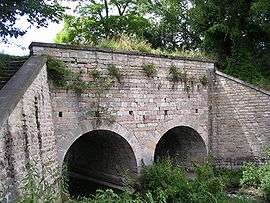
Pont des Arvaux | ||
| ||
 Noiron-sous-Gevrey | ||
|
Location within Bourgogne-Franche-Comté region  Noiron-sous-Gevrey | ||
| Coordinates: 47°11′40″N 5°04′51″E / 47.1944°N 5.0808°E / 47.1944; 5.0808Coordinates: 47°11′40″N 5°04′51″E / 47.1944°N 5.0808°E / 47.1944; 5.0808 | ||
| Country | France | |
| Region | Bourgogne-Franche-Comté | |
| Department | Côte-d'Or | |
| Arrondissement | Dijon | |
| Canton | Gevrey-Chambertin | |
| Intercommunality | Sud Dijonnais | |
| Government | ||
| • Mayor (2008–2014) | Claudette Guillemaud | |
| Area1 | 6.56 km2 (2.53 sq mi) | |
| Population (2008)2 | 1,024 | |
| • Density | 160/km2 (400/sq mi) | |
| Time zone | CET (UTC+1) | |
| • Summer (DST) | CEST (UTC+2) | |
| INSEE/Postal code | 21458 / 21910 | |
| Elevation | 195–227 m (640–745 ft) | |
|
1 French Land Register data, which excludes lakes, ponds, glaciers > 1 km² (0.386 sq mi or 247 acres) and river estuaries. 2 Population without double counting: residents of multiple communes (e.g., students and military personnel) only counted once. | ||
.svg.png)
Noiron-sous-Gevrey is a commune in the Côte-d'Or department in eastern France.
Population
| Historical population | ||
|---|---|---|
| Year | Pop. | ±% |
| 1962 | 214 | — |
| 1968 | 264 | +23.4% |
| 1975 | 360 | +36.4% |
| 1982 | 405 | +12.5% |
| 1990 | 394 | −2.7% |
| 1999 | 705 | +78.9% |
| 2008 | 1,024 | +45.2% |
See also
References
| Wikimedia Commons has media related to Noiron-sous-Gevrey. |
This article is issued from Wikipedia - version of the 7/21/2016. The text is available under the Creative Commons Attribution/Share Alike but additional terms may apply for the media files.