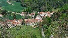
Reulle-Vergy
| Reulle-Vergy | |
|---|---|
 | |
 Reulle-Vergy | |
|
Location within Bourgogne-Franche-Comté region  Reulle-Vergy | |
| Coordinates: 47°11′14″N 4°53′44″E / 47.1872°N 4.8956°E / 47.1872; 4.8956Coordinates: 47°11′14″N 4°53′44″E / 47.1872°N 4.8956°E / 47.1872; 4.8956 | |
| Country | France |
| Region | Bourgogne-Franche-Comté |
| Department | Côte-d'Or |
| Arrondissement | Dijon |
| Canton | Gevrey-Chambertin |
| Intercommunality | Gevrey-Chambertin |
| Government | |
| • Mayor (2008–2014) | Aleth Detot |
| Area1 | 6.13 km2 (2.37 sq mi) |
| Population (2008)2 | 100 |
| • Density | 16/km2 (42/sq mi) |
| Time zone | CET (UTC+1) |
| • Summer (DST) | CEST (UTC+2) |
| INSEE/Postal code | 21523 / 21220 |
| Elevation | 320–526 m (1,050–1,726 ft) |
|
1 French Land Register data, which excludes lakes, ponds, glaciers > 1 km² (0.386 sq mi or 247 acres) and river estuaries. 2 Population without double counting: residents of multiple communes (e.g., students and military personnel) only counted once. | |
Reulle-Vergy is a commune in the Côte-d'Or department in eastern France.
Population
| Historical population | ||
|---|---|---|
| Year | Pop. | ±% |
| 1962 | 100 | — |
| 1968 | 98 | −2.0% |
| 1975 | 82 | −16.3% |
| 1982 | 84 | +2.4% |
| 1990 | 105 | +25.0% |
| 1999 | 99 | −5.7% |
| 2008 | 100 | +1.0% |
See also
References
| Wikimedia Commons has media related to Reulle-Vergy. |
This article is issued from Wikipedia - version of the 4/11/2013. The text is available under the Creative Commons Attribution/Share Alike but additional terms may apply for the media files.