Isycoed

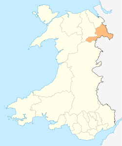
Isycoed (Welsh: Is-coed) is a local government community in Wrexham County Borough, Wales. It lies around 5 miles to the east of Wrexham, close to the River Dee on the border with England.[1]
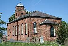
There is a primary school in Bowling Bank, and a late-Georgian church, dedicated to St. Paul, in Isycoed village,[2] which was designated as a Grade II listed building on 20 June 1996.
Governance
The area was traditionally considered part of the parish of Holt, but was made a separate parish in 1827, incorporating the townships of Cacca Dutton, Dutton Diffaeth, Dutton y Bran, Ridley, and Sutton.[2] The civil parish, established in 1935, was replaced by the Community of Isycoed under the Local Government Act 1972.[3]
The community today contains the villages or hamlets of Isycoed, Bowling Bank, and Ridleywood; part of the Wrexham Industrial Estate occupies the western side of the community area. At the time of the 2001 census, the population was 348,[4] increasing to 388 at the 2011 Census.[5]
St Paul's Church
The first church on this site was built in 1718 and it was replaced by another building in 1742. The present church was built in 1829 and is dedicated to St Paul. It is built of brown brick with light headers to give a chequer-board effect. The side door and the adjacent windows have been blocked up. The medium-height tower is at the west end, the top stage is octagonal with a leaded roof and it is surmounted by a weather vane. The church was designated as a Grade II listed building on 20 June 1996, assessed as being "a good example of an earlier C19 church".[6]
References
- ↑ Concise Road Atlas: Britain. AA Publishing. 2015. p. 48. ISBN 978-0-7495-7743-8.
- 1 2 Isycoed, St Paul, GENUKI
- ↑ "Local Government Act 1972". National Archives. Legislation.gov.uk. Retrieved 2 May 2016.
- ↑ Isycoed Community, Office for National Statistics.
- ↑ "Community population 2011". Retrieved 18 November 2015.
- ↑ "Church of St Paul, Isycoed". British Listed Buildings. Retrieved 2 May 2016.
External links
![]() Media related to Isycoed at Wikimedia Commons
Media related to Isycoed at Wikimedia Commons
Coordinates: 53°02′45″N 2°53′33″W / 53.04573°N 2.8924°W
