Jōbōji, Iwate
| Jōbōji 浄法寺町 | ||
|---|---|---|
| Former municipality | ||
|
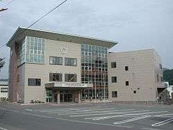
former Jōbōji Town Hall | ||
| ||
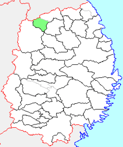 Location of Jōbōji in Iwate Prefecture | ||
 Jōbōji Location in Japan | ||
| Coordinates: 40°11′N 141°09′E / 40.183°N 141.150°ECoordinates: 40°11′N 141°09′E / 40.183°N 141.150°E | ||
| Country | Japan | |
| Region | Tōhoku | |
| Prefecture | Iwate Prefecture | |
| District | Iwate | |
| Merged |
September 1, 2005 (now part of Ninohe) | |
| Area | ||
| • Total | 179.70 km2 (69.38 sq mi) | |
| Population (January 1, 2006) | ||
| • Total | 4,959 | |
| • Density | 27.6/km2 (71/sq mi) | |
| Symbols | ||
| • Tree | Cercidiphyllum japonicum | |
| • Flower | Platycodon grandiflorus | |
| • Bird | Common cuckoo | |
| Time zone | Japan Standard Time (UTC+9) | |

Jōbōji (浄法寺町 Jōbōji-machi) was a town located in Ninohe District, Iwate Prefecture, Japan.
The village of Jōbōji was created on April 1, 1889 within Ninohe District with the establishment of the municipality system. Jōbōji was raised to town status on December 25, 1940. On January 1, 2006, Jōbōji was merged into the expanded city of Ninohe. and no longer exists as an independent municipality.
As of January 2006, the town had an estimated population of 4,959 and a population density of 27.6 persons per km2. The total area was 179.70 km2.
External links
- Official website of Hachimantai (Japanese)
This article is issued from Wikipedia - version of the 11/10/2015. The text is available under the Creative Commons Attribution/Share Alike but additional terms may apply for the media files.