Jalalpur Sharif
| Jalalpur Sharif | |
|---|---|
| Country |
|
| Province | Punjab |
| Population | |
| • Total | 30,000 |
| Time zone | PST (UTC+5) |
| Calling code | +92544 |
Coordinates: 32°39′34″N 73°24′19″E / 32.65944°N 73.40528°E
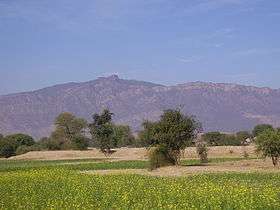
Jalalpur Sharif is a small town located in Jhelum, and is a Union Council of Pind Dadan Khan Tehsil in Jhelum District, Punjab province, Pakistan.[1] It is located at 32°39'34N 73°24'19E,[2] making it approximately 48 km south west of the city of Jhelum.
History
Jalalpur modern name came from the renaming of its ancient name, Girjakh, by its king Malik Darwesh Khan Janjua who was also a high-ranking general of the Imperial Mughal Army under Emperor Jalaluddin Muhammad Akbar’s reign.
It is stated that Malik Darwesh ordered the renaming of Girjakh (part of his extended kingdom) to Jalalpur, when Emperor Akbar visited him.[3] This was done in honour of the Emperor and the Janjua family's relationship.[4] Jalalpur at this point was a flourishing centre of trade for the region.[5]
The history of the region dates back to 326 BC when Alexander the Great and his troops camped at Jalalpur Sharif, located on the right bank of Jhelum River, prior to the historic Battle of Jhelum against Raja Porus. During this battle, which was fought across the river, Alexander’s horse Bucephalus was killed but his remains were brought back and buried close to Jalalpur Sharif where subsequently Alexander built a city named after his horse. The ruins of an ancient city are spread across the hills towards the east of Jalalpur Sharif.
A notable landmark of the town is the Shrine of Pir Syed Ghulam Haidar Ali Shah, a prominent (Chishti) leader of the Punjab, Pakistan, (d. 1908).[6] It is this association with the shrine of one of the most well known Chishti spiritual leaders of the sub continent that the title of Sharif is pronounced together with Jalalpur. Pir Syed Ghulam Haidar Ali Shah and his descendants, notably including his grandson, who was given the title Amir-e-Hizbullah, Pir Syed Muhammad Fazal Shah were extremely influential in the spiritual development of the Muslims of Punjab, and also in the political movement that eventually led to the creation of the Islamic Republic of Pakistan.[7]
The Khewra Salt Mines, the world's second largest salt mine, is located 37 km west of Jalalpur Sharif in Khewra. Before separation of India/Pakistan, Hindus used to live in this area. There are still some remains of their livings. It is at the bank of River Jhelum.
Administration
Jalalpur Sharif has one police station, and there are three higher secondary and high schools[8] they are:
- Govt. Higher Secondary School
- Govt. High School for Girls
- Govt. High School for Boys
- Govt. High School Wagh
- Govt. Model High School Bair Faqiran (co-edu)
- Govt. High School Pind Swika
- Govt. Girls High School Wagh
- GC University Pindi Said Pur
Senior Headmaster Muhammad Iqbal Haral Retired from Govt. High School Wagh after 15 years spent in that school. He also served in Govt. High School Jalalpur Sharif About 25 years and he has a good repute in these areas for education.
References
- ↑ Tehsils & Unions in the District of Jhelum – Government of Pakistan
- ↑ Jalalpur Sharif coordinates identified with Wikimapia
- ↑ Evaluation of District Council, Jhelum by Nasir Ahmad, Abdul Aziz Awan, Noor Mohammad, Pub.Pakistan Academy for Rural Development, 1989, p16
- ↑ Panjāb Under the Great Mughals, 1526-1707 Bakhshish Singh Nijjar, Thacker 1968, p191
- ↑ The Ancient Geography of India, Sir Alexander Cunningham, Adamant Media 1871, p163
- ↑ Muslim Networks from Hajj to Hip Hop (Islamic Civilization and Muslim Networks), Miriam Cooke & Bruce B. Lawrence, University of North Carolina Press 2005, p235
- ↑ Religious Leadership and the Pakistan Movement in the Punjab, David Gilmartin, Modern Asian Studies, Vol. 13, No. 3 (1979), pp. 485-517
- ↑ Pind Dadan Khan Welfare Society
External links
- Wikimapia map
- Chishti Photos
- Greek Connections
- History of Jalalpur Sharif
- Local Photos
- More Local Photos
