Jawhar
| Jawhar जव्हार | |
|---|---|
| City | |
|
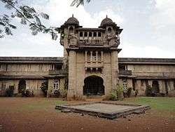
The Jaivilas Palace | |
 Jawhar Location of Jawhar in Maharashtra | |
| Coordinates: 19°55′N 73°14′E / 19.92°N 73.23°ECoordinates: 19°55′N 73°14′E / 19.92°N 73.23°E | |
| Country |
|
| State | Maharashtra |
| District | Palghar |
| Government | |
| • Type | Municipal management |
| • Body | Municipal Council Jawhar |
| • Member of Parliament | Chintaman Vanaga |
| Elevation | 447 m (1,467 ft) |
| Population (2001) | |
| • Total | 11,296 |
| Languages | |
| • Official | Marathi |
| Time zone | IST (UTC+5:30) |
| Pincode | 401 603 |
| Telephone code | 02520 |
| Vehicle registration | MH04 and MH48 |
Jawhar is a city and a municipal council in Palghar district in the Indian state of Maharashtra. Jawhar was a capital city of the erstwhile Princely state of Jawhar. Situated in the ranges of the Western Ghats, Jawhar is known for its picturesque setting and a vibrant cultural heritage. It is one of the very few tribal regions of Maharashtra and is famous for its vibrant Warli painting that are a characteristic landmark of this place. Established in 1918, Jawhar is one of the oldest municipal councils in the state of Maharashtra.
History
The Jawhar state was founded by Raja Jayaba Mukne in 1343, with Jawhar as its capital. The Jawhar state went through many transitions and lasted for over six hundred years until its accession into the Union of India in 1947. During the British Raj, as a Princely state, it was a part of Bombay Presidency and had a 9-gun salute status. Although a capital city, Jawhar's development was largely neglected by successive rulers, due to a low revenue generation and haphazard organisation. However, Jawhar witnessed a significant development in the reign of Raja Patangshah IV and subsequent rulers. Raja Patang Shah V (Yashswant Rao) Mukne was the last ruler of Jawhar before its formal integration in the Union of Indian in 1947.[1]
Geography
Jawhar is a hill station located at 19°55′N 73°14′E / 19.92°N 73.23°E. It has an average elevation of 447 metres (1466 feet). Owing to its picturesque location and cool climate it is also known as the Mahabaleshwar of Palghar district. It is about 80 km from Nasik and about 145 km from Mumbai by road.
Tourist attractions
Jaivilas Palace
The Jai Vilas Palace is the most popular historic tourist attraction in Jawhar. This neoclassical style palace was built by Raja Yashwant Rao Mukane. This palace is also known as Raj Bari and used to be a residential palace of the Munke royal family. Built on a hill top, this palace is a master piece of architecture with blend of Western and Indian styles of architecture in majestic pink stones. The interiors of this palace display the rich culture and lifestyle of tribal kings of Munke family. The palace is surrounded by a beautiful garden with a dense forest like foliage, having trees of Cashew everywhere.
The place is built in the Syenite stone, brought from an quarry at Sakhara, which is 12 km from its location. It is said that when the work of the palace was completed, the quarry from, which the stones were extracted was broken down and covered; the exact location of the quarry is lost in time. The Geological Department, of Government of India has now taken up a task to locate the lost quarry. Due to its unique architecture style and location, the palace has featured in several films in Marathi and Hindi.
Hanuman Point
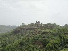
Towards east of the city, nearly 1 to 2 km from the city center, there is an old temple of Maruti; this temple is known as Katya Maruti mandir due surrounded dark forest of cactus. The temple is surrounded by valleys on three sides. The valley is nearly 500 feet deep. During renovation a view point was created near the temple, which is known as Hanuman Point. During the day time, one can see the historical fort of Shahapur Maholi from this point, while during night time, it is possible to see lights of train in Kasara ghat form this point. The valley also known as Devkobacha Kada. The Hanuman point (Sunrise Point ) is a beautiful place to witness sunrise from surrounding valley, near by high hills & the Royal Jaivilas Palace.
Sunset Point
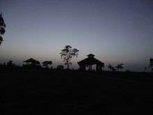
Nearly 0.5 km towards west, from the heart of the city, there is a heritage of lovers called a Sunset point. The shape of the valley around the Sunset point is like Bow, therefore earlier it was known as Dhanukamal. During sunset, one can see the mountain of Mahalaxmi near Dahanu, which is nearly 60 km from Jawhar.
Dadarkopara
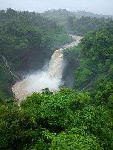
Dabhosa- Dadarkopara -waterfall is only 18 km away from on Jawhar — Talasari — Silvasa Road. This waterfall is on Lendi river and on other side of river at Sarsun there is Dadarkopara Waterfall. The Dadarkopara fall usually gets dry during summer, therefore is also known as Suka (Dry) fall. The height of waterfall is about 300 feet. The water from Lendi river first flows in the flask shaped rock & from there it flows in 5 feet by 5 feet flask shaped open natural container made of rocks. The waterfalls are surround by straight mountains of height not less than 600 feet on both sides and are covered with Medicinal plants.
Dabhosa waterfall is one of the highest waterfalls in Maharashtra. To top it all this is one of the very few waterfalls which is perrennial. The crater shaped bowl into which the waterfall cascades and the lake at the bottom of the waterfall is truly a spectacular site for the urbanite.
How to reach Dabhosa: Village Dabhosa, Off Jawhar Silvassa Road, Taluka Jawhar, District.
Kal Mandavi Waterfall

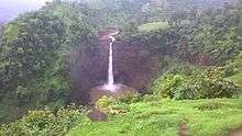
The Kal Mandavi waterfall is about 100 meters in height and it flows throughout the year, and not just during the monsoons season. However, the most scenic views of the waterfall are during monsoon season. Kalmandi is name of waterfall that situated at near Apatale gaon.
How to reach: Jawhar to Kalmandi is approximately 5–6 km via Jawhar-Zap road.
Khad-Khad Dam
This is one of the major dams near Jawhar city with beautiful scenic locations. The place provides a peaceful natural ambience to soothe a tired mind & body, besides this excess water of dam flows through the huge rocks (just ahead the dam) which can be seen in a form of a waterfall.
Shirpamal
The Shirpamal is a popular place of historical importance. The emperor of the Maratha Kingdom, Chhatrapati Shivaji Maharaj had stayed here over night, in-route to his Surat plunder. This Point was developed by Advocate Rajaram Mukne, then president of Jawhar Municipal Council in 1995.
Administration
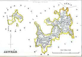
Jawhar is an administrative headquarters of Jawhar Taluka.
| Town/Village Name | Population | Males | Females |
|---|---|---|---|
| Adkhadak | 342 | 187 | 155 |
| Aine | 513 | 251 | 262 |
| Akare | 1,434 | 691 | 743 |
| Akhar | 705 | 330 | 375 |
| Alyachimet | 345 | 173 | 172 |
| Anantnagar (N.V.) | 742 | 385 | 357 |
| Aptale | 1,225 | 587 | 638 |
| Ayare | 1,132 | 560 | 572 |
| Barawadpada | 618 | 283 | 335 |
| Behadgaon (N.V.) | 1,227 | 597 | 630 |
| Bhagada (N.V.) | 430 | 207 | 223 |
| Bharasatmet | 464 | 223 | 241 |
| Bhuritek | 703 | 347 | 356 |
| Bopdari | 1,083 | 514 | 569 |
| Borale | 1,392 | 702 | 690 |
| Chambharshet | 1,674 | 829 | 845 |
| Chandgaon (N.V.) | 528 | 261 | 267 |
| Chandranagar (N.V.) | 246 | 119 | 127 |
| Chandrapur (N.V.) | 340 | 174 | 166 |
| Chauk | 1,152 | 575 | 577 |
| Dabheri | 1,825 | 938 | 887 |
| Dabhlon | 1,202 | 561 | 641 |
| Dabhose | 1,466 | 734 | 732 |
| Dadar Koprapada | 454 | 225 | 229 |
| Dadhari | 446 | 232 | 214 |
| Dahul | 216 | 111 | 105 |
| Daskod | 372 | 181 | 191 |
| Dehare | 1,666 | 901 | 765 |
| Dengachimet | 1,225 | 592 | 633 |
| Devgaon | 1,315 | 662 | 653 |
| Dhanoshi | 924 | 453 | 471 |
| Dharampur | 1,174 | 546 | 628 |
| Dongarwadi | 698 | 353 | 345 |
| Ganeshnagar (N.V.) | 1,005 | 505 | 500 |
| Gangapur (N.V.) | 172 | 78 | 94 |
| Garadwadi | 686 | 327 | 359 |
| Ghiwande | 1,649 | 805 | 844 |
| Gorthan | 778 | 394 | 384 |
| Hade | 818 | 419 | 399 |
| Hateri | 990 | 474 | 516 |
| Hiradpada | 1,487 | 756 | 731 |
| Jambhulmaya (N.V.) | 560 | 279 | 281 |
| Jamsar | 1,461 | 730 | 731 |
| Jawhar | 11,298 | 5,977 | 5,321 |
| Jayeshwar (N.V.) | 532 | 274 | 258 |
| Juni Jawhar | 1,460 | 704 | 756 |
| Kadachimet | 577 | 280 | 297 |
| Kalamvihira | 352 | 164 | 188 |
| Kardhan | 272 | 140 | 132 |
| Kasatwadi | 752 | 380 | 372 |
| Kashivali Tarf Dengachimet | 740 | 344 | 396 |
| Kaulale | 1,496 | 724 | 772 |
| Kayari | 725 | 347 | 378 |
| Kelghar | 1,029 | 499 | 530 |
| Khadkhad | 654 | 330 | 324 |
| Khambale | 1,198 | 672 | 526 |
| Kharonda | 1,891 | 937 | 954 |
| Khidse | 344 | 166 | 178 |
| Kirmire | 995 | 482 | 513 |
| Kogade | 613 | 310 | 303 |
| Kortad | 977 | 493 | 484 |
| Kuturvihir | 367 | 183 | 184 |
| Malghar | 664 | 325 | 339 |
| Manmohadi | 237 | 109 | 128 |
| Medha | 1,160 | 576 | 584 |
| Medhe | 245 | 115 | 130 |
| Morchachapada | 259 | 120 | 139 |
| Nandgaon | 1,757 | 935 | 822 |
| Nandnmal | 407 | 202 | 205 |
| Nyahale Bk. | 1,582 | 806 | 776 |
| Nyahale Kh | 2,000 | 1,051 | 949 |
| Ozar | 1,439 | 683 | 756 |
| Palshin | 181 | 93 | 88 |
| Pathardi | 1,369 | 685 | 684 |
| Pimpalgaon | 1,756 | 876 | 880 |
| Pimpalshet | 1,287 | 651 | 636 |
| Pimprun | 346 | 165 | 181 |
| Poyshet | 772 | 358 | 414 |
| Radhanagari (N.V.) | 330 | 156 | 174 |
| Raitale | 2,431 | 1,246 | 1,185 |
| Rajewadi | 987 | 473 | 514 |
| Ramnagar (N.V.) | 412 | 198 | 214 |
| Ramnagar (N.V.) | 391 | 201 | 190 |
| Rampur (N.V.) | 480 | 237 | 243 |
| Ruighar | 564 | 266 | 298 |
| Sakharshet | 1,852 | 926 | 926 |
| Sakur | 1,219 | 414 | 805 |
| Sarsun | 2,200 | 1,057 | 1,143 |
| Savarpada | 732 | 375 | 357 |
| Shirasgaon (N.V.) | 426 | 210 | 216 |
| Shiroshi | 807 | 387 | 420 |
| Shivaji Nagar | 912 | 455 | 457 |
| Shivajinagar (N.V.) | 338 | 162 | 176 |
| Shrirampur | 1,307 | 647 | 660 |
| Shrirampur (N.V.) | 419 | 208 | 211 |
| Suryanagar (N.V.) | 503 | 246 | 257 |
| Suryanagar (N.V.) | 425 | 203 | 222 |
| Talasari | 903 | 434 | 469 |
| Tilonde | 1,337 | 632 | 705 |
| Tuljapur (N.V.) | 400 | 188 | 212 |
| Umbarkheda | 670 | 332 | 338 |
| Vangani | 1,021 | 537 | 484 |
| Vavar | 1,833 | 959 | 874 |
| Vijaynagar (N.V.) | 1,077 | 514 | 563 |
| Wadoli | 975 | 472 | 503 |
| Walwande | 1,427 | 696 | 731 |
| Winwal | 2,127 | 1,140 | 987 |
| Zap | 1,917 | 1,089 | 828 |
| Total | 111,039 | 55,467 | 55,572 |
In popular culture
Jawhar and its surrounding places have featured in a number films.
- In the film Great Grand Masti, the Jaivilas Palace was shown as an ancestral haveli of one of the lead characters.
- The song Mast Malanga from Marathi movie One Way Ticket was shot at the Jaivilas Palace.
