Jobos Bay National Estuarine Research Reserve
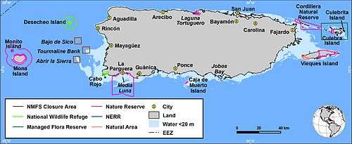
Jobos Bay National Estuarine Research Reserve (JBNERR, sometimes JOBNERR or JOBANERR) is a federally protected estuary in Aguirre, Puerto Rico. The bay is an intertidal tropical ecosystem dominated by seagrass beds, coral reefs, and mangroves.[1] In an area of 1140 hectares, the reserve contains five distinct habitat types and provides sanctuary to several endangered species. JBNERR is one of 28 reserves that comprise the National Oceanic and Atmospheric Administration’s (NOAA) National Estuarine Research Reserve System. The reserve is operated in conjunction with the Puerto Rico Department of Natural and Environmental Resources (DRNA).
History
Jobos Bay is located on the south coast of Puerto Rico in Aguirre, between Salinas and Guayama. Most of the land in the reserve was owned by the Aguirre Corporation, which operated an extensive sugarcane farm and sugar mill in the region. After the burst of the sugar industry, the corporation closed in 1980 and sold the land to the Commonwealth of Puerto Rico. JBNERR was established as a National Estuarine Sanctuary in 1981.
Since the 1980s, land-use in the areas surrounding JBNERR has continued to change. The reserve borders the Aguirre State Forest on the East, a fisherman village (Las Mareas) on the West, and agricultural and residential land on the north. Due to urbanization in the region and shifting irrigation regimes, watershed dynamics have changed significantly.
Ecology
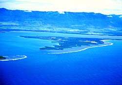
Jobos Bay is a tropical estuary with five distinct habitat types grading roughly from the ocean landward: coral reefs, seagrass beds, mangrove forests, mudflats, and evergreen littoral forests. Jobos is the second largest estuary in Puerto Rico by total area and the largest (by a factor of three) by total coastline.[1] The Jobos mangroves are estimated to comprise 42.6% of that habitat type on the south coast of Puerto Rico.
At least seven endangered species can be found at JBNERR.
See also
External links
References
- 1 2 JOBOS BAY ESTUARINE PROFILE: A NATIONAL ESTUARINE RESEARCH RESERVE. 2002. Editor: Raph Field Authors: Pedro O. Robles, Carmen M. Gonzalez, Eddie N. Laboy, and Jorge Capella.
Coordinates: 17°57′27.26″N 66°13′20.13″W / 17.9575722°N 66.2222583°W