Guana Tolomato Matanzas National Estuarine Research Reserve
| Guana Tolomato Matanzas National Estuarine Research Reserve | |
|---|---|
| GTM Research Reserve | |
|
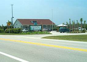
Headquarters building | |
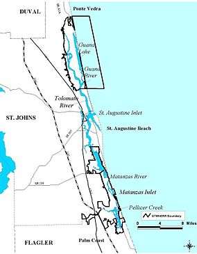
 Guana Tolomato Matanzas National Estuarine Research Reserve - Map | |
| Location | St. Johns and Flagler Counties, Florida, United States |
| Nearest city | St. Augustine |
| Coordinates | 29°59′17″N 81°20′49″W / 29.988°N 81.347°W[1]Coordinates: 29°59′17″N 81°20′49″W / 29.988°N 81.347°W[2] |
| Area | 73,352 acres (29,685 ha) |
| Established | 1999 |
| http://www.dep.state.fl.us/coastal/sites/gtm/ | |
Guana Tolomato Matanzas National Estuarine Research Reserve (GTMNERR) on Florida's First Coast is part of a network of 28 protected coastal areas along the United States coast from Alaska to Puerto Rico, The National Estuarine Research Reserve System. This program is a partnership between NOAA and the US coastal states with the goal of protecting estuarine lands and water.[3]
Description
The Reserve is over 73,352 acres (29,685 ha) of salt marsh and mangrove tidal wetlands. It includes oyster beds, tidal lagoons, critical habitat and offshore seas spanning St. Johns County and Flagler County. This estuarine ecological system produces a rich abundance of marine life including numerous commercially and recreationally valuable forms of sea life. The upland areas include pine flatwoods, maritime hammock, coastal strands and dunes, and mangroves. (GTMNERR) stretches from Summer Haven in the south all the way to Ponte Vedra Beach in the north, which is over 30 miles.[4]
GTM Research Reserve Environmental Education Center
The GTM Research Reserve Environmental Education Center, operated by the Friends of the GTM Reserve, is located at 505 Guana River Road in Ponte Vedra Beach, Florida. The center features interpretive exhibits about the estuary system and the reserve, aquariums, classrooms, teaching and working laboratories, an auditorium and an outdoor amphitheater. Education programs focus on the importance of estuarine ecosystems.
Guana Tract

In 2004 the Guana River State Park was acquired by the Guana Tolomato Matanzas National Estuarine Research Reserve and is now included in the reserve. It is no longer a State Park.[5] The research reserve is located along State Highway A1A, between St. Augustine and Jacksonville. Located in St. Johns County, the research reserve is a federal/state partnership with the Florida Department of Environmental Protection as the state program administrator and the National Oceanic and Atmospheric Administration on the federal side.
History
The tract was privately owned and open to the public for hunting and fishing prior to state acquisition. During the period of private ownership, the Guana River was dammed in 1957, to flood the upstream marshes in order to enhance wintering waterfowl habitat. The result was the creation of the present-day Guana Lake. The lake water is brackish near its southern terminus at Guana Dam and gradually turns into a freshwater reservoir as one travels away from the dam. Both saltwater and freshwater fish species exist in the same body of water.
The land was purchased from Gate Petroleum with Conservation and Recreational Lands and Save Our Coast funds by the State of Florida in 1984 and divided into Guana River State Park and the Guana River Wildlife Management Area. In 2004 with the construction of the GTM Environmental Education Center, the management of the state park lands was turned over to the GTM Research Reserve to manage as part of the larger research reserve.
Bounded by the Atlantic Ocean and the Intracoastal Waterway (Tolomato River), the Guana Tract, which includes the Guana Tolomato Matanzas National Estuarine Research Reserve (GTM Research Reserve) and Guana River Wildlife Management Area, comprises some 12,000 acres (49 km2) of public conservation and recreational uplands.
Biology
Within its 60,000 acres (240 km2) are beaches, sand dunes, salt marshes, mangroves, tidal wetlands, tidal creeks, oyster beds, estuarine lagoons, maritime hardwood hammock, freshwater depression marshes, pond pine flatwoods and shell mound forests.
The GTMNERR is an important calving ground for the endangered North Atlantic right whale and is also home to other aquatic and amphibious wildlife, like porpoises, manatees, sea turtles, gopher tortoises, American alligators, indigo snakes and river otters. The reserve is home to peregrine falcons, bald eagles, and the endangered Anastasia Island beach mouse (Peromyscus polionotus phasma). Other birds that can be viewed are diving and wading birds, brown and white pelicans, wood storks, and roseate spoonbills. The reserve also contains the northern most extent of mangrove habitat on the east coast of the United States.
Recreational activities
Activities include hiking, fishing, boating, picnicing, and wildlife viewing. Amenities include over nine miles (14 km) of nature trails in an unspoiled natural setting. The reserve also contains seventeen archaeological sites, shell middens at Shell Bluff Landing and Wright's Landing, as well as a prehistoric earthen burial mound. Guana continues to be a community gathering place for fishing, canoeing, and other aquatic activities.
See also
References
- ↑ "Guana Tolomato Matanzas National Estuarine Research Reserve (NOAA)". protectedplanet.net.
- ↑ "Guana Tolomato Matanzas National Estuarine Research Reserve (NOAA)". protectedplanet.net.
- ↑ "The National Estuarine Research Reserve System". Retrieved 2007-01-27.
- ↑ "Guana - Tolomato - Matanzas National Estuarine Research Reserve". Retrieved 2007-01-27.
- ↑
Sources
- Guana River Reserve at Wildernet
- GTMNERR
- Guana River Marsh Aquatic Preserve
- Guana Tolomato Matanzas Reserve, Florida
- The Guana Tolomato Matanzas National Estuarine Research Reserve
External links
- Official site
- Friends of the GTM Reserve - GTM Research Reserve Environmental Education Center

