Joseph Nicollet
| Joseph Nicollet | |
|---|---|
 Portrait and autograph of J.N. Nicollet | |
| Born |
July 24, 1786 Cluses, Savoy, France |
| Died |
September 11, 1843 (aged 57) Washington D.C, United States |
| Nationality | French |
| Occupation | Explorer, mathematician |
| Known for | Cartography of the Mississippi River |
Joseph Nicolas Nicollet (July 24, 1786 – September 11, 1843), also known as Jean-Nicolas Nicollet, was a French geographer, astronomer, and mathematician known for mapping the Upper Mississippi River basin during the 1830s. Nicollet led three expeditions in the region between the Mississippi and Missouri Rivers, primarily in Minnesota, South Dakota, and North Dakota.[1]
Before emigrating to the United States, Nicollet was a professor of mathematics at Collège Louis-le-Grand, and a professor and astronomer at the Paris Observatory with Pierre-Simon Laplace.[1][2] Political and academic changes in France led Nicollet to travel to the United States to do work that would bolster his reputation among academics in Europe.[3]
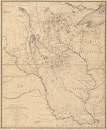
Nicollet's maps were among the most accurate of the time, correcting errors made by Zebulon Pike, and they provided the basis for all subsequent maps of the American interior.[1] They were also among the first to depict elevation by hachuring and the only maps to use regional Native American placenames.[1] Nicollet's Map of the Hydrographical Basin of the Upper Mississippi was published in 1843, following his death.[1] Nicollet Tower, located in Sisseton, South Dakota is a monument to Nicollet and his work and was constructed in 1991.[4]
Early life and education
Nicollet was born in Cluses, Savoy, France.[1][2] He was very bright, showing aptitude in mathematics and astronomy that earned him a scholarship to the Jesuit college in Chambéry and led him to begin teaching mathematics at age 19.[1][2] In 1817, he was appointed as a professor and astronomer at the Paris Observatory and worked with scientist and mathematician Pierre-Simon Laplace.[2] While working at the observatory, Nicollet discovered a comet and built a reputation as an expert in astronomy and physical geography.[1] Afterward, he worked as a mathematics professor at the Collège Louis-le-Grand during the 1820s
Emigration to the United States
Nicollet encountered financial and professional difficulties that were the result of political turbulence in France following the 1830 Revolution as well as the rising dominance of physics as a laboratory science.[1] Penniless, he emigrated to the United States in 1832, sailing from the port of Brest.[1] Nicollet hoped to boost his reputation among European academics through his work in the United States. He intended to make a "scientific tour" of the country and had a goal of using his expertise to accurately map the Mississippi River Valley.[3] He arrived in Washington, D.C., where he met with scientists and government officials, discussing scientific surveys of the country.[3] Nicollet traveled to New Orleans, from where he intended to proceed to St. Louis, Missouri, but due to a cholera outbreak, travel by steamboat was practically halted, and instead he spent the next three years traveling throughout the south, primarily between New Orleans and Baltimore.[1][3] Nicollet finally arrived in St. Louis in 1835.[3]
Mapping the Mississippi
Upon his arrival in St. Louis, Nicollet gained support for his plan to map the Mississippi River from the American Fur Company and the wealthy Choteau family.[1][2] From St. Louis, he took a boat up the river to Fort Snelling, Minnesota.[1] Nicollet led three expeditions exploring the Upper Mississippi, mostly in the area that is now Minnesota, North Dakota and South Dakota.
First expedition
The first expedition took place in 1836–37 and was privately funded by American Fur and the Choteaus.[1][2] Nicollet departed Fort Snelling by canoe on July 29, 1836, accompanied by Chagobay, an Ojibwe chief, his nine-year-old son, and a half-French guide named Brunia.[1] Nicollet explored the Mississippi to its source of Lake Itasca and the nearby Mississippi tributary, the St. Croix River.[2] The results of this expedition corrected an error in Zebulon Pike's 1805 map, which placed the mouth of the Crow Wing River too far to the west, rendering all maps of this area inaccurate.[1]
Second expedition
Upon his return to Washington, D.C. to report his findings, Nicollet was appointed to head the newly formed Corps of Topographical Engineers and lead a War Department-funded expedition to map the area between the Mississippi and Missouri Rivers in order to correct the western maps affected by Pike's mistake.[1] The expedition party set out on June 18, 1838 from Traverse des Sioux.[5] The party was composed of John C. Frémont, who was appointed by the War Department to assist on the expedition in lieu of a military escort, Joseph Renville Jr., and Joseph LaFromboise, an agent for the American Fur Company who was half French, half Native American. On July 4, the expedition arrived at Pipestone Quarry, where the party members carved their initials on a rock.[1] From there, the party proceeded along the Minnesota and Blue Earth Rivers toward Spirit Lake, Iowa.[6]
Third expedition
In his third expedition, guided by Louison Freniere, Nicollet retained the assistance from Fremont and was joined for part of his journey by the Jesuit Missionary Pierre-Jean De Smet.[1][2] De Smet used skills learned from Nicollet to make his own maps of the Missouri River basin.[7] On this and on his second expedition, Nicollet was joined by botanist Charles Geyer, who took extensive notes cataloging the area's native plants.[6] This third and final expedition was also government funded and took Nicollet northwest from Iowa along the Missouri River toward Fort Pierre, South Dakota.[6] Nicollet's efforts were hampered by the sinking of the Steamboat Pirate in April 1839, which was carrying supplies for his expedition.[8] The second leg of this expedition set out from Fort Pierre for Devil's Lake, North Dakota on July 11, 1839. From there, Nicollet travelled back across the Coteau des Prairies to Fort Snelling.[1]
Legacy

On September 11, 1839, Nicollet returned to Washington, D.C. where he worked on consolidating the information collected during the expeditions. He fully intended to return to Minnesota to continue his work, but failing health led to his death in Washington in 1843.[1][2] Later that year, a book containing much of his work, Map of the Hydrographical Basin of the Upper Mississippi, was published.[1] The maps in the book were highly accurate and covered a region more than half the size of Europe. Nicollet's were also among the first in the world to depict elevation by hachuring and are among the only sources for original Native American place names in the region.[1] Many of Nicollet's sketches and journals from his expeditions are housed at the Library of Congress, the Smithsonian Institution, and the National Archives.[6]
Nicollet's name is applied to several places in the region he explored, including Nicollet Island, Nicollet Avenue in Minneapolis, Nicollet County[9] and the city of Nicollet, all located in Minnesota.
Nicollet Tower
The Joseph N. Nicollet Tower and Interpretive Center, a monument to Nicollet and his work, was constructed by Kyburz-Carlson Construction Co. in 1991 in Sisseton, South Dakota, near the path Nicollet took from Devil's Lake back to Fort Snelling on his final expedition.[1][4] Banker and Sisseton resident Harold Torness became fascinated with Nicollet's story and work after reading Joseph N. Nicollet on the Plains and Prairies, a translation of Nicollet's journals, and raised $335,000 from just seven local donors in order to build the monument.[4][10] The tower is constructed primarily of Douglas-fir from Idaho, with concrete pillars and steel bolts and supports. It is 80 feet tall at its peak, and there are 96 steps to the top observation platform. Six counties in three states (South Dakota, North Dakota, and Minnesota) can be seen from the top, where there is a view of the Laurentian Divide, the Coteau des Prairies and the ancient glacial valley that Nicollet mapped.[4][10] The Interpretive Center was constructed at the same time as the tower. Both the tower and the Interpretive Center were designed by Clarence Herges and were built by Kyburz-Calrson Construction.[10] The Interpretive Center houses 2,400 square feet of classroom space and exhibits, including Nicollet's map and a mural of Nicollet's meeting with Wanata, chief of the Yankton Dakota.[1][4]
References
- 1 2 3 4 5 6 7 8 9 10 11 12 13 14 15 16 17 18 19 20 21 22 23 24 25 Bray, Martha. "Joseph N. Nicollet Biographical Summary". Heritage Museums of the Coteau des Prairies. Retrieved 2012-02-27.
- 1 2 3 4 5 6 7 8 9 "Joseph Nicolas Nicollet". Encyclopædia Britannica Online. Encyclopædia Britannica, Inc. 2012. Retrieved 2012-02-27.
- 1 2 3 4 5 Bray, Martha (1970-02-16). "Joseph Nicolas Nicollet, Geologist". Joseph Nicolas Nicollet, Geologist. American Philosophical Society. 114 (1): 37–59. JSTOR 985723.
- 1 2 3 4 5 "History -Joseph N. Nicollet Tower and Interpretive Center". Heritage Museums of the Coteau des Prairies. Retrieved 2012-02-27.
- ↑ "Joseph N. Nicollet's Journal: June 18 - June 20". Nicollet's 1838 Expedition from Ft. Snelling to Pipestone. Retrieved 2012-02-27.
- 1 2 3 4 "J. N. Nicollet Journal". Re-imaging Joseph N. Nicollet's Mapmaking Expeditions. Retrieved 2012-02-27.
- ↑ Whittaker, William (2008). "Pierre-Jean De Smet's Remarkable Map of the Missouri River Valley, 1839: What Did He See in Iowa?". Journal of the Iowa Archeological Society. 55: 1–13.
- ↑ Nicollet, Joseph (1976). Joseph N. Nicollet on the plains and prairies: the expeditions of 1838-39 (reprint ed.). St. Paul: Minnesota Historical Society. p. 141.
- ↑ Upham, Warren (1920). Minnesota Geographic Names: Their Origin and Historic Significance. Minnesota Historical Society. p. 371.
- 1 2 3 "History of Construction". Heritage Museums of the Coteau des Prairies. Retrieved 2012-02-27.
Further reading
- Nicollet, Joseph Nicolas (1970). The journals of Joseph N. Nicollet: a scientist on the Mississippi headwaters: with notes on indian life, 1836-37. Minnesota Historical Society.
- Bray, Martha Coleman (1980). Joseph Nicollet and his map. American Philosophical Society.
- Nicollet, Joseph Nicolas; Bray, Edmund; Bray, Martha Coleman (1993). Joseph N. Nicollet on the plains and prairies: the expeditions of 1838-39, with journals, letters, and notes on the Dakota Indians. Minnesota Historical Society Press.
External links
- Nicollet Project Website at St. Olaf College.
- Report Intended to Illustrate of the Hydrographical Basin of the Upper Mississippi River, retrieved May 29, 2009 from Google Book Search.
- John Cushman Abbott Exhibit Supplement—includes a discussion of Nicollet and his book Report Intended to Illustrate a Map of the Hydrographical Basin of the Upper Mississippi River, and a downloadable pdf file of the book.