Nicollet, Minnesota
| Nicollet, Minnesota | |
|---|---|
| City | |
|
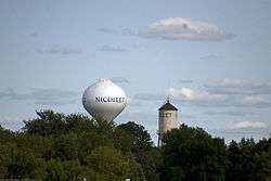
Nicollet's old and new water towers | |
 Location of Nicollet, Minnesota | |
| Coordinates: 44°16′25″N 94°11′18″W / 44.27361°N 94.18833°W | |
| Country | United States |
| State | Minnesota |
| County | Nicollet |
| Government | |
| • Type | Mayor - Council |
| • Mayor | Fred Froehlich |
| Area[1] | |
| • Total | 0.94 sq mi (2.43 km2) |
| • Land | 0.94 sq mi (2.43 km2) |
| • Water | 0 sq mi (0 km2) |
| Elevation | 984 ft (300 m) |
| Population (2010)[2] | |
| • Total | 1,093 |
| • Estimate (2012[3]) | 1,122 |
| • Density | 1,162.8/sq mi (449.0/km2) |
| Time zone | Central (CST) (UTC-6) |
| • Summer (DST) | CDT (UTC-5) |
| ZIP code | 56074 |
| Area code(s) | 507 |
| FIPS code | 27-46150 |
| GNIS feature ID | 0648544[4] |
| Website | http://nicollet.org/ |
Nicollet is a city in Nicollet County, Minnesota, United States. The population was 1,093 at the 2010 census.[5]
It is part of the Mankato–North Mankato Metropolitan Statistical Area.
U.S. Route 14 and Minnesota State Highways 99 and 111 are the three main arterial routes in the community. Nearby Swan Lake Wildlife Management Area is one of the most significant waterfowl breeding areas in the upper Midwest.
History
The city of Nicollet was named for Joseph Nicollet, a French explorer. A post office called Nicollet, along with the town of Nicollet, was established in 1858 by William A. Mills. Nicollet was platted on June 30, 1874 by James H. Stewart and Walter L. Brackenridge as a railroad town.[6][7][8] Nicollet was incorporated in 1881.[9]
Geography
According to the United States Census Bureau, the city has a total area of 0.94 square miles (2.43 km2), all of it land.[1]
Demographics
| Historical population | |||
|---|---|---|---|
| Census | Pop. | %± | |
| 1880 | 99 | — | |
| 1890 | 263 | 165.7% | |
| 1900 | 330 | 25.5% | |
| 1910 | 338 | 2.4% | |
| 1920 | 404 | 19.5% | |
| 1930 | 434 | 7.4% | |
| 1940 | 434 | 0.0% | |
| 1950 | 493 | 13.6% | |
| 1960 | 493 | 0.0% | |
| 1970 | 618 | 25.4% | |
| 1980 | 709 | 14.7% | |
| 1990 | 795 | 12.1% | |
| 2000 | 889 | 11.8% | |
| 2010 | 1,093 | 22.9% | |
| Est. 2015 | 1,138 | [10] | 4.1% |
| U.S. Decennial Census[11] 2012 Estimate[12] | |||
2010 census
As of the census[2] of 2010, there were 1,093 people, 429 households, and 307 families residing in the city. The population density was 1,162.8 inhabitants per square mile (449.0/km2). There were 445 housing units at an average density of 473.4 per square mile (182.8/km2). The racial makeup of the city was 98.4% White, 0.2% African American, 0.2% Asian, 0.1% from other races, and 1.1% from two or more races. Hispanic or Latino of any race were 3.4% of the population.
There were 429 households of which 39.9% had children under the age of 18 living with them, 55.9% were married couples living together, 11.0% had a female householder with no husband present, 4.7% had a male householder with no wife present, and 28.4% were non-families. 23.5% of all households were made up of individuals and 7.9% had someone living alone who was 65 years of age or older. The average household size was 2.55 and the average family size was 3.00.
The median age in the city was 31.9 years. 29.8% of residents were under the age of 18; 7.8% were between the ages of 18 and 24; 30% were from 25 to 44; 22.4% were from 45 to 64; and 10.1% were 65 years of age or older. The gender makeup of the city was 49.8% male and 50.2% female.
2000 census
As of the census of 2000, there were 889 people, 344 households, and 241 families residing in the city. The population density was 1,008.2 inhabitants per square mile (390.1/km²). There were 350 housing units at an average density of 396.9 per square mile (153.6/km²). The racial makeup of the city was 98.20% White, 0.11% African American, 0.34% Native American, 0.34% Asian, and 1.01% from two or more races. Hispanic or Latino of any race were 0.90% of the population.
There were 344 households out of which 36.3% had children under the age of 18 living with them, 58.1% were married couples living together, 7.3% had a female householder with no husband present, and 29.9% were non-families. 25.3% of all households were made up of individuals and 10.2% had someone living alone who was 65 years of age or older. The average household size was 2.58 and the average family size was 3.12.
In the city the population was spread out with 28.1% under the age of 18, 8.3% from 18 to 24, 31.4% from 25 to 44, 21.0% from 45 to 64, and 11.1% who were 65 years of age or older. The median age was 34 years. For every 100 females there were 104.4 males. For every 100 females age 18 and over, there were 102.9 males.
The median income for a household in the city was $42,500, and the median income for a family was $51,563. Males had a median income of $34,722 versus $22,500 for females. The per capita income for the city was $19,237. About 1.3% of families and 3.7% of the population were below the poverty line, including 2.2% of those under age 18 and 3.4% of those age 65 or over.
References
- 1 2 "US Gazetteer files 2010". United States Census Bureau. Retrieved 2012-11-13.
- 1 2 "American FactFinder". United States Census Bureau. Retrieved 2012-11-13.
- ↑ "Population Estimates". United States Census Bureau. Retrieved 2013-05-28.
- ↑ "US Board on Geographic Names". United States Geological Survey. 2007-10-25. Retrieved 2008-01-31.
- ↑ "2010 Census Redistricting Data (Public Law 94-171) Summary File". American FactFinder. United States Census Bureau. Retrieved 27 April 2011.
- ↑ http://nicollet.org/history-of-nicollet/
- ↑ "Nicollet County". Jim Forte Postal History. Retrieved 23 March 2015.
- ↑ Chicago and North Western Railway Company (1908). A History of the Origin of the Place Names Connected with the Chicago & North Western and Chicago, St. Paul, Minneapolis & Omaha Railways. p. 107.
- ↑ Upham, Warren (1920). Minnesota Geographic Names: Their Origin and Historic Significance. Minnesota Historical Society. p. 373.
- ↑ "Annual Estimates of the Resident Population for Incorporated Places: April 1, 2010 to July 1, 2015". Retrieved July 2, 2016.
- ↑ United States Census Bureau. "Census of Population and Housing". Retrieved September 12, 2013.
- ↑ "Annual Estimates of the Resident Population: April 1, 2010 to July 1, 2012". Retrieved September 12, 2013.
Municipalities and communities of Nicollet County, Minnesota, United States | ||
|---|---|---|
| Cities | 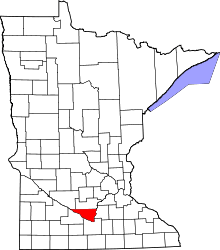 | |
| Townships | ||
| Unincorporated communities | ||
| Ghost town | ||
| Footnotes | ‡This populated place also has portions in an adjacent county or counties | |
| Core Cities |  | ||||||
|---|---|---|---|---|---|---|---|
| Incorporated Places |
| ||||||
| Counties | |||||||
† indicates a county seat. ‡ indicates that it is partially in the metropolitan area. | |||||||
Coordinates: 44°16′34″N 94°11′15″W / 44.27611°N 94.18750°W